TopoQuest Logo
Do you find TopoQuest useful?
Help keep TopoQuest running and adding new maps/features by donating!
Bitcoin:  19c7KJd3qBynnjoSw5npx9KScwjBe4ifkT
Litecoin:  LXs6TkuXGGXo1vDsWCkWVdjQX94eUKd6ui
Home View Maps Find Maps Find Places Resources & Links


Bassfield, Mississippi Topographic Map

USGS Map Title: Bassfield, MS
USGS Map MRC: 31089D6
DRG (GeoTIFF) Download: o31089d6.tif


Neighboring USGS Topographic Map Quads:


  Prentiss East, MS  
31089E7
 

  Lake Mike Connor, MS  
31089E6
 

  Williamsburg, MS  
31089E5
 

  Bunker Hill, MS  
31089D7
 

  Bassfield, MS  
31089D6
 

  Sumrall, MS  
31089D5
 

  Columbia North, MS  
31089C7
 

  Improve, MS  
31089C6
 

  Oloh, MS  
31089C5


Map MRC Location:

N32°
W90°
N32°
W89°
H8 H7 H6 H5 H4 H3 H2 H1
G8 G7 G6 G5 G4 G3 G2 G1
F8 F7 F6 F5 F4 F3 F2 F1
E8 E7 E6 E5 E4 E3 E2 E1
D8 D7 D6 D5 D4 D3 D2 D1
C8 C7 C6 C5 C4 C3 C2 C1
B8 B7 B6 B5 B4 B3 B2 B1
A8 A7 A6 A5 A4 A3 A2 A1
N31°
W90°
N31°
W89°

Bassfield, MS USGS 1:24K Topographic Map Preview:
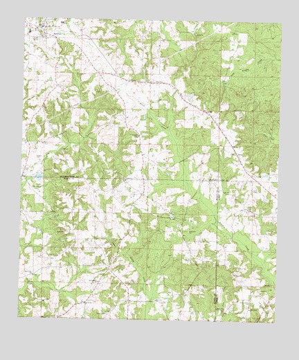
Bassfield, MS USGS Topographic Map
Click on map above to begin viewing in our Map Viewer.

This topographic map contains these locations and features:
Feature Name Type Latitude Longitude GNIS ID View Map
BassfieldPopulated PlaceN31.4966°W89.7395°666563View Map
Bassfield Baptist ChurchChurchN31.4974°W89.7409°689718View Map
Bassfield City CemeteryCemeteryN31.4913°W89.7473°691320View Map
Bassfield Elementary SchoolSchoolN31.4985°W89.7320°710581View Map
Bassfield High SchoolSchoolN31.4943°W89.7473°710582View Map
Bassfield Post OfficePost OfficeN31.4959°W89.7410°2596249View Map
Bassfield Sewage Lagoon DamDamN31.4885°W89.7401°680728View Map
Bassfield Volunteer Fire DepartmentBuildingN31.4964°W89.7429°2667750View Map
BethelPopulated PlaceN31.4335°W89.7001°689649View Map
Bethel Baptist ChurchChurchN31.4335°W89.6998°666903View Map
Blackburn-Carter CemeteryCemeteryN31.4413°W89.7067°691315View Map
Blue Spring ChurchChurchN31.3818°W89.7179°667321View Map
Bond CemeteryCemeteryN31.4427°W89.7270°691318View Map
Faithway Landmark ChurchChurchN31.4182°W89.6767°669898View Map
Hickory GrovePopulated PlaceN31.3946°W89.6462°691930View Map
Hickory Grove Baptist ChurchChurchN31.3947°W89.6465°2596470View Map
Hickory Grove CemeteryCemeteryN31.3832°W89.6376°671155View Map
Hickory Grove ChurchChurchN31.3799°W89.6498°671162View Map
Hickory Grove ChurchChurchN31.3805°W89.6376°671163View Map
Hickory Grove School (historical)SchoolN31.3932°W89.6442°685782View Map
Holly Springs Christian Methodist Episcopal ChurchChurchN31.4910°W89.7403°2596795View Map
Holly Springs Methodist ChurchChurchN31.4918°W89.7395°689742View Map
Hubie Spights Lake DamDamN31.4352°W89.7384°680718View Map
L L Roberts Methodist ChurchChurchN31.4962°W89.7398°689748View Map
Lamar Puckett Lake DamDamN31.4702°W89.6701°680725View Map
Lott CemeteryCemeteryN31.4443°W89.6437°691309View Map
Lowland CemeteryCemeteryN31.4524°W89.6948°672933View Map
Lowland School (historical)SchoolN31.4546°W89.6990°689750View Map
Magee-Sullivan CemeteryCemeteryN31.4582°W89.7256°691317View Map
McDonald CemeteryCemeteryN31.4443°W89.6626°691313View Map
McLeod CemeteryCemeteryN31.4877°W89.6973°691314View Map
McPhail CemeteryCemeteryN31.4424°W89.7431°673428View Map
MelbaPopulated PlaceN31.4449°W89.6456°692063View Map
Melba CemeteryCemeteryN31.4446°W89.6467°691310View Map
Melba School (historical)SchoolN31.4527°W89.6501°689752View Map
Michelle Lake DamDamN31.3985°W89.7134°680707View Map
Morning Star ChurchChurchN31.3905°W89.7120°673825View Map
MorrisPopulated PlaceN31.4624°W89.6615°692085View Map
Mount Gilead CemeteryCemeteryN31.3841°W89.6840°710560View Map
Mount Gilead ChurchChurchN31.3835°W89.6831°674002View Map
New Hope Missionary Baptist ChurchChurchN31.4948°W89.6761°2596245View Map
New UnionPopulated PlaceN31.3935°W89.7431°710564View Map
New Union CemeteryCemeteryN31.3929°W89.7442°710588View Map
New Union ChurchChurchN31.3938°W89.7437°674858View Map
Old Broom CemeteryCemeteryN31.4124°W89.6684°675164View Map
Old Melba CemeteryCemeteryN31.4452°W89.6484°691311View Map
Pine Ridge ChurchChurchN31.3907°W89.6265°675870View Map
Raybourn CemeteryCemeteryN31.3774°W89.7067°676503View Map
Saint Paul's Missionary Baptist ChurchChurchN31.4926°W89.7394°689769View Map
Saint Peter's Catholic ChurchChurchN31.4949°W89.7446°689770View Map
Stewart-Thompson CemeteryCemeteryN31.4810°W89.7228°691316View Map
Supervisor District 3CivilN31.4879°W89.6695°711916View Map
Town of BassfieldCivilN31.4960°W89.7449°2405213View Map
Tri - Community Volunteer Fire Department Station 4BuildingN31.3962°W89.7339°2667921View Map
Wheeler CemeteryCemeteryN31.4904°W89.7465°691319View Map
Wilks CemeteryCemeteryN31.4299°W89.7451°679698View Map
Wilks CemeteryCemeteryN31.4379°W89.7481°679699View Map
Williamson CemeteryCemeteryN31.4421°W89.6637°691312View Map
Williamson CemeteryCemeteryN31.4213°W89.6401°679724View Map

Note: Coordinates in the location and feature list above are referenced to NAD83 datum.


Copyright (C) 2008-2024 Ryan Niemi / Sunset Dynamics ... All Rights Reserved