TopoQuest Logo
Do you find TopoQuest useful?
Help keep TopoQuest running and adding new maps/features by donating!
Bitcoin:  19c7KJd3qBynnjoSw5npx9KScwjBe4ifkT
Litecoin:  LXs6TkuXGGXo1vDsWCkWVdjQX94eUKd6ui
Home View Maps Find Maps Find Places Resources & Links


Linden, Alabama Topographic Map

USGS Map Title: Linden, AL
USGS Map MRC: 32087C7
DRG (GeoTIFF) Download: o32087c7.tif


Neighboring USGS Topographic Map Quads:


  Jefferson, AL  
32087D8
 

  Old Spring Hill, AL  
32087D7
 

  Gallion, AL  
32087D6
 

  Myrtlewood North, AL  
32087C8
 

  Linden, AL  
32087C7
 

  Thomaston West, AL  
32087C6
 

  Myrtlewood South, AL  
32087B8
 

  Miller, AL  
32087B7
 

  Magnolia, AL  
32087B6


Map MRC Location:

N33°
W88°
N33°
W87°
H8 H7 H6 H5 H4 H3 H2 H1
G8 G7 G6 G5 G4 G3 G2 G1
F8 F7 F6 F5 F4 F3 F2 F1
E8 E7 E6 E5 E4 E3 E2 E1
D8 D7 D6 D5 D4 D3 D2 D1
C8 C7 C6 C5 C4 C3 C2 C1
B8 B7 B6 B5 B4 B3 B2 B1
A8 A7 A6 A5 A4 A3 A2 A1
N32°
W88°
N32°
W87°

Linden, AL USGS 1:24K Topographic Map Preview:
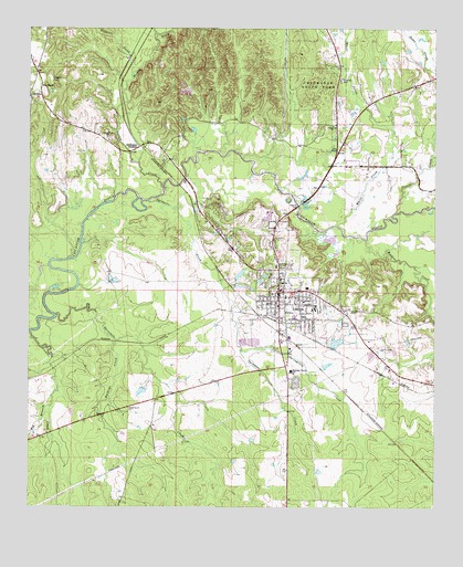
Linden, AL USGS Topographic Map
Click on map above to begin viewing in our Map Viewer.

This topographic map contains these locations and features:
Feature Name Type Latitude Longitude GNIS ID View Map
Allen CreekStreamN32.3149°W87.8631°137561View Map
Barton CreekStreamN32.3335°W87.8342°113528View Map
Bible ChapelChurchN32.3435°W87.7800°114204View Map
Big BranchStreamN32.2765°W87.8681°114242View Map
Buckeye CreekStreamN32.2940°W87.8483°115137View Map
Cates (historical)LocaleN32.2849°W87.8708°137583View Map
Chalk Level African Methodist Episcopal Zion ChurchChurchN32.2760°W87.8442°115908View Map
Chickasaw State ParkParkN32.3590°W87.7870°116031View Map
City of LindenCivilN32.3001°W87.7926°2404934View Map
Doctor Max McCord Junior LakeReservoirN32.3095°W87.8492°130403View Map
Doctor Max McCord Junior Lake DamDamN32.3085°W87.8483°130404View Map
George P Austin Junior High SchoolSchoolN32.3021°W87.7867°165350View Map
Glass Lake Number OneReservoirN32.2931°W87.7802°130383View Map
Glass Lake Number One DamDamN32.2935°W87.7817°130384View Map
Grant HillSummitN32.3629°W87.8686°119240View Map
Hopewell Baptist ChurchChurchN32.3499°W87.7817°151814View Map
Huggins CreekStreamN32.3629°W87.8436°120526View Map
Jefferson StationLocaleN32.3443°W87.8408°120834View Map
LindenPopulated PlaceN32.3063°W87.7981°152070View Map
Linden Baptist ChurchChurchN32.3060°W87.8000°151464View Map
Linden Baptist School (historical)SchoolN32.3118°W87.7986°137621View Map
Linden Church of ChristChurchN32.3096°W87.7986°151465View Map
Linden DivisionCivilN32.2769°W87.8095°161619View Map
Linden Elementary SchoolSchoolN32.3049°W87.7958°137622View Map
Linden Grammer School (historical)SchoolN32.3099°W87.7964°137623View Map
Linden High SchoolSchoolN32.3093°W87.7975°137624View Map
Linden Methodist ChurchChurchN32.3104°W87.7978°151466View Map
Linden Police DepartmentBuildingN32.3078°W87.7977°2751831View Map
Linden Post OfficePost OfficeN32.3045°W87.7987°168785View Map
Linden Presbyterian ChurchChurchN32.3090°W87.7986°151467View Map
Linden Volunteer Fire Department Station 1BuildingN32.3060°W87.7954°2691140View Map
Linden Volunteer Fire Department Station 2BuildingN32.2869°W87.7953°2691592View Map
Little Rock ChurchChurchN32.3468°W87.8511°155139View Map
Loboco (historical)LocaleN32.2890°W87.8658°137625View Map
Marengo County CourthouseBuildingN32.3065°W87.7975°151625View Map
Marengo County Fire and Rescue Squad Station 1BuildingN32.3043°W87.8030°2691582View Map
Marengo County Fire and Rescue Squad Station 2BuildingN32.3427°W87.7832°2691583View Map
Marengo County HospitalHospitalN32.3129°W87.7986°122280View Map
Marengo County LibraryBuildingN32.3113°W87.7978°158363View Map
Marengo County SchoolSchoolN32.2857°W87.7942°152223View Map
Marengo County Sheriff's OfficeBuildingN32.3072°W87.7971°2751834View Map
Mount Pilgrim ChurchChurchN32.3446°W87.8381°137640View Map
Norwood FordCrossingN32.3226°W87.8589°137646View Map
Owensby Lake Number OneReservoirN32.3109°W87.8100°130410View Map
Owensby Number One DamDamN32.3101°W87.8117°130409View Map
Paul S Owensby Lake Dam Number 2DamN32.3068°W87.8117°130401View Map
Paul S Owensby Lake Number TwoReservoirN32.3079°W87.8101°130400View Map
Pin HookPopulated PlaceN32.3576°W87.8717°124753View Map
Powell CreekStreamN32.3271°W87.7620°158906View Map
ProvidencePopulated PlaceN32.3418°W87.7806°137658View Map
Providence Baptist ChurchChurchN32.3601°W87.7564°154153View Map
Providence CemeteryCemeteryN32.3596°W87.7561°1730263View Map
Springfield CreekStreamN32.2910°W87.8097°127287View Map
Sycamore CreekStreamN32.3301°W87.8381°127609View Map
Threemile CreekStreamN32.2999°W87.8664°155275View Map
Town of ProvidenceCivilN32.3424°W87.7761°2407165View Map
Watkins CreekStreamN32.3199°W87.7714°128635View Map
Whirl CreekStreamN32.3235°W87.7800°128846View Map
WIIQ-TV (Demopolis)TowerN32.3671°W87.8675°161249View Map

Note: Coordinates in the location and feature list above are referenced to NAD83 datum.


Copyright (C) 2008-2024 Ryan Niemi / Sunset Dynamics ... All Rights Reserved