TopoQuest Logo
Do you find TopoQuest useful?
Help keep TopoQuest running and adding new maps/features by donating!
Bitcoin:  19c7KJd3qBynnjoSw5npx9KScwjBe4ifkT
Litecoin:  LXs6TkuXGGXo1vDsWCkWVdjQX94eUKd6ui
Home View Maps Find Maps Find Places Resources & Links


Basin Mountain, Colorado Topographic Map

USGS Map Title: Basin Mountain, CO
USGS Map MRC: 37107B8
DRG (GeoTIFF) Download: o37107b8.tif


Neighboring USGS Topographic Map Quads:


  Hesperus, CO  
37108C1
 

  Durango West, CO  
37107C8
 

  Durango East, CO  
37107C7
 

  Kline, CO  
37108B1
 

  Basin Mountain, CO  
37107B8
 

  Loma Linda, CO  
37107B7
 

  Pinkerton Mesa, CO  
37108A1
 

  Long Mountain, CO  
37107A8
 

  Bondad Hill, CO  
37107A7


Map MRC Location:

N38°
W108°
N38°
W107°
H8 H7 H6 H5 H4 H3 H2 H1
G8 G7 G6 G5 G4 G3 G2 G1
F8 F7 F6 F5 F4 F3 F2 F1
E8 E7 E6 E5 E4 E3 E2 E1
D8 D7 D6 D5 D4 D3 D2 D1
C8 C7 C6 C5 C4 C3 C2 C1
B8 B7 B6 B5 B4 B3 B2 B1
A8 A7 A6 A5 A4 A3 A2 A1
N37°
W108°
N37°
W107°

Basin Mountain, CO USGS 1:24K Topographic Map Preview:
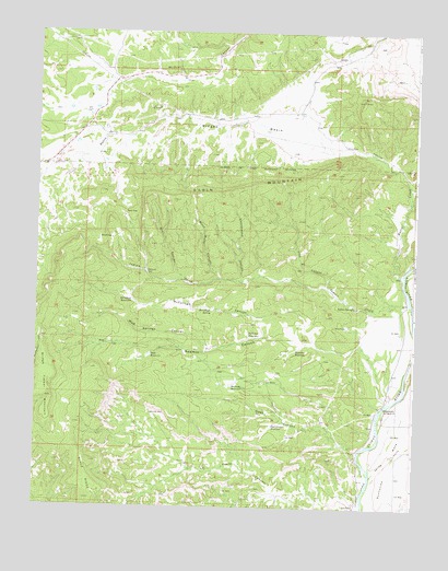
Basin Mountain, CO USGS Topographic Map
Click on map above to begin viewing in our Map Viewer.

This topographic map contains these locations and features:
Feature Name Type Latitude Longitude GNIS ID View Map
Basin CreekStreamN37.1867°W107.8792°179296View Map
Basin MountainSummitN37.2056°W107.9549°179307View Map
Black Water CanyonValleyN37.1851°W107.9393°179286View Map
Box CanyonValleyN37.1843°W107.9504°179301View Map
Bridge Timber MountainSummitN37.1640°W107.9973°179294View Map
Cottonwood CanyonValleyN37.1854°W107.9326°179287View Map
Dads ReservoirReservoirN37.1649°W107.9623°179304View Map
Durango Fire and Rescue Station 8BuildingN37.2452°W107.9504°2695559View Map
East GapGapN37.2022°W107.9709°179305View Map
Goat CanyonValleyN37.1395°W107.8932°179292View Map
Goat Canyon ReservoirReservoirN37.1464°W107.9218°179291View Map
Herrera ReservoirReservoirN37.1665°W107.9144°179303View Map
Indian CreekStreamN37.1794°W107.8767°179297View Map
Indian SpringSpringN37.1778°W107.8953°179295View Map
La Plata County Sheriff's OfficeBuildingN37.2476°W107.8789°2757230View Map
La PostaPopulated PlaceN37.1253°W107.8951°202996View Map
McCullogh CanyonValleyN37.1681°W107.9086°179300View Map
McCullogh ReservoirReservoirN37.1791°W107.9684°179302View Map
McCullogh SpringSpringN37.1769°W107.9426°179289View Map
Montoya ReservoirReservoirN37.1570°W107.9353°179290View Map
Mountain Bell-Durango HeliportAirportN37.2417°W107.8762°204368View Map
Mud Springs CanyonValleyN37.1661°W107.9432°179299View Map
Peacock MineMineN37.2478°W107.9284°1734992View Map
Porter MineMineN37.2472°W107.9465°1734993View Map
Ridges BasinBasinN37.2250°W107.9340°179308View Map
San Isidro ChurchChurchN37.1622°W107.9490°194618View Map
Sawmill CanyonValleyN37.1677°W107.8924°179298View Map
Spring GulchValleyN37.1336°W107.8891°184356View Map
Sullivan ReservoirReservoirN37.1706°W107.9301°179288View Map
Weaselskin BridgeBridgeN37.1519°W107.8848°184358View Map
West GapGapN37.1958°W107.9790°179306View Map

Note: Coordinates in the location and feature list above are referenced to NAD83 datum.


Copyright (C) 2008-2024 Ryan Niemi / Sunset Dynamics ... All Rights Reserved