TopoQuest Logo
Do you find TopoQuest useful?
Help keep TopoQuest running and adding new maps/features by donating!
Bitcoin:  19c7KJd3qBynnjoSw5npx9KScwjBe4ifkT
Litecoin:  LXs6TkuXGGXo1vDsWCkWVdjQX94eUKd6ui
Home View Maps Find Maps Find Places Resources & Links


Lexington, Alabama Topographic Map

USGS Map Title: Lexington, AL
USGS Map MRC: 34087H3
DRG (GeoTIFF) Download: o34087h3.tif


Neighboring USGS Topographic Map Quads:


  Loretto, TN  
35087A4
 

  Bonnertown, TN  
35087A3
 

  Appleton, TN  
35087A2
 

  Center Hill, AL  
34087H4
 

  Lexington, AL  
34087H3
 

  Union Hill, AL  
34087H2
 

  Wheeler Dam, AL  
34087G4
 

  Rogersville, AL  
34087G3
 

  Cairo, AL  
34087G2


Map MRC Location:

N35°
W88°
N35°
W87°
H8 H7 H6 H5 H4 H3 H2 H1
G8 G7 G6 G5 G4 G3 G2 G1
F8 F7 F6 F5 F4 F3 F2 F1
E8 E7 E6 E5 E4 E3 E2 E1
D8 D7 D6 D5 D4 D3 D2 D1
C8 C7 C6 C5 C4 C3 C2 C1
B8 B7 B6 B5 B4 B3 B2 B1
A8 A7 A6 A5 A4 A3 A2 A1
N34°
W88°
N34°
W87°

Lexington, AL USGS 1:24K Topographic Map Preview:
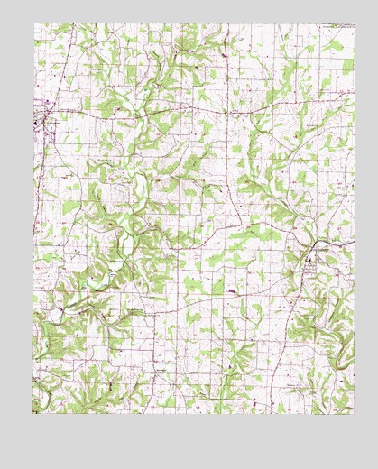
Lexington, AL USGS Topographic Map
Click on map above to begin viewing in our Map Viewer.

This topographic map contains these locations and features:
Feature Name Type Latitude Longitude GNIS ID View Map
AndersonPopulated PlaceN34.9284°W87.2664°154965View Map
Anderson Junior High SchoolSchoolN34.9245°W87.2675°165635View Map
Anderson Post OfficePost OfficeN34.9253°W87.2682°2770173View Map
Anderson Volunteer Fire DepartmentBuildingN34.9248°W87.2684°2682701View Map
Arthur Post Office (historical)Post OfficeN34.9681°W87.3131°166170View Map
Barnett CemeteryCemeteryN34.9292°W87.3717°163817View Map
Barnett CemeteryCemeteryN34.9148°W87.3745°113503View Map
Beaverdam BranchStreamN34.9320°W87.3364°113753View Map
Beaverdam Church (historical)ChurchN34.9284°W87.3134°141141View Map
Bethlehem Congregational Methodist ChurchChurchN34.9065°W87.3314°114151View Map
Bills BranchStreamN34.8798°W87.3020°114345View Map
Birch BranchStreamN34.9945°W87.2778°114360View Map
Brown CemeteryCemeteryN34.9154°W87.3458°114991View Map
Carter SpringSpringN34.9913°W87.3142°115670View Map
Cedar Hill (historical)Populated PlaceN34.8884°W87.3014°155511View Map
Cedar Hill School (historical)SchoolN34.8840°W87.3014°155512View Map
Corn BranchStreamN34.9651°W87.2897°116647View Map
Corum (historical)Populated PlaceN34.9084°W87.3317°145126View Map
Corum CemeteryCemeteryN34.9081°W87.3414°116661View Map
Corum Chapel Missionary Baptist ChurchChurchN34.9123°W87.3334°116662View Map
Corum HollowValleyN34.9081°W87.3595°116663View Map
Cotts CreekStreamN34.9719°W87.3345°116698View Map
Crossroads BranchStreamN34.9956°W87.3514°116904View Map
Dry BranchStreamN34.9770°W87.3403°117522View Map
East Fork Anderson CreekStreamN34.9304°W87.2653°117752View Map
GrassyPopulated PlaceN34.9715°W87.2997°156430View Map
Grassy ChurchChurchN34.9718°W87.2992°163826View Map
Grassy Memorial Chapel ChurchChurchN34.9718°W87.2997°163827View Map
Grassy School (historical)SchoolN34.9718°W87.2981°145208View Map
Hammond BranchStreamN34.9506°W87.3159°119655View Map
Hammond CemeteryCemeteryN34.9326°W87.3133°145215View Map
Hammond School (historical)SchoolN34.9284°W87.3142°155515View Map
Harmon CemeteryCemeteryN34.9490°W87.3414°119742View Map
Herston BranchStreamN34.8801°W87.3475°120002View Map
Howard School (historical)SchoolN34.8890°W87.2875°155517View Map
Hurn SpringSpringN34.9674°W87.2644°120565View Map
Hurn Spring BranchStreamN34.9648°W87.2703°120566View Map
Hurricane (historical)Populated PlaceN34.8820°W87.2709°145225View Map
Hurricane BranchStreamN34.8815°W87.2642°120576View Map
Hurricane Cumberland Presbyterian ChurchChurchN34.8837°W87.2717°151833View Map
Hurricane Springs Primitive Baptist ChurchChurchN34.9284°W87.2661°145227View Map
Ingram FordCrossingN34.9054°W87.2659°156514View Map
Ingram Mill (historical)LocaleN34.9062°W87.2656°145229View Map
Ivy BluffCliffN34.9145°W87.3489°120728View Map
LexingtonPopulated PlaceN34.9693°W87.3711°121530View Map
Lexington Fire DepartmentBuildingN34.9749°W87.3683°2682957View Map
Lexington Police DepartmentBuildingN34.9680°W87.3710°2751950View Map
Lexington Post OfficePost OfficeN34.9654°W87.3714°2788992View Map
Lexington SchoolSchoolN34.9681°W87.3742°142080View Map
Locks Crossing Church of ChristChurchN34.9081°W87.3328°152716View Map
Marshall BranchStreamN34.9540°W87.3395°122305View Map
Middle Fork Anderson CreekStreamN34.9476°W87.2834°122686View Map
Monk BranchStreamN34.9481°W87.3306°122949View Map
Moody FordCrossingN34.8931°W87.2564°156730View Map
Nebo Cumberland Presbyterian ChurchChurchN34.9331°W87.3745°152591View Map
Nebo School (historical)SchoolN34.9334°W87.3745°157363View Map
New Hope Baptist ChurchChurchN34.8865°W87.3625°142122View Map
Northside ChurchChurchN34.9759°W87.3656°142131View Map
Old Bethel Church (historical)ChurchN34.8773°W87.3328°141142View Map
Oxford Church of ChristChurchN34.9787°W87.2639°152829View Map
Oxford School (historical)SchoolN34.9793°W87.2636°142142View Map
Pole Bridge BranchStreamN34.9945°W87.2781°125089View Map
Portertown CemeteryCemeteryN34.9851°W87.3531°125184View Map
Portertown School (historical)SchoolN34.9768°W87.3514°142157View Map
PowellPopulated PlaceN34.9779°W87.2536°142159View Map
Rice CemeteryCemeteryN34.8867°W87.3633°125592View Map
Rogersville DivisionCivilN34.8860°W87.2867°165837View Map
Sawmill HollowValleyN34.9817°W87.3281°126444View Map
Shelton CemeteryCemeteryN34.9562°W87.3445°126685View Map
Sledge FordCrossingN34.9240°W87.3395°142195View Map
Sledge Ford BridgeBridgeN34.9240°W87.3395°126966View Map
Springfield BranchStreamN34.8759°W87.3711°127279View Map
Stout HollowValleyN34.9359°W87.3422°127443View Map
Strickland HollowValleyN34.9023°W87.2600°127466View Map
Town of AndersonCivilN34.9148°W87.2716°2405149View Map
Town of LexingtonCivilN34.9652°W87.3735°2406013View Map
West Fork Anderson CreekStreamN34.9473°W87.2834°128766View Map
White BranchStreamN34.9540°W87.3142°128859View Map
WhiteheadPopulated PlaceN34.8881°W87.3272°128895View Map
Whitehead ChurchChurchN34.8848°W87.3278°163836View Map
Whitehead School (historical)SchoolN34.8879°W87.3286°142259View Map
WWLX-AM (Lexington)TowerN34.9770°W87.3695°161109View Map

Note: Coordinates in the location and feature list above are referenced to NAD83 datum.


Copyright (C) 2008-2024 Ryan Niemi / Sunset Dynamics ... All Rights Reserved