TopoQuest Logo
Do you find TopoQuest useful?
Help keep TopoQuest running and adding new maps/features by donating!
Bitcoin:  19c7KJd3qBynnjoSw5npx9KScwjBe4ifkT
Litecoin:  LXs6TkuXGGXo1vDsWCkWVdjQX94eUKd6ui
Home View Maps Find Maps Find Places Resources & Links


Basile, Louisiana Topographic Map

USGS Map Title: Basile, LA
USGS Map MRC: 30092D5
DRG (GeoTIFF) Download: o30092d5.tif


Neighboring USGS Topographic Map Quads:


  Soileau, LA  
30092E6
 

  Duralde, LA  
30092E5
 

  Eunice North, LA  
30092E4
 

  Elton, LA  
30092D6
 

  Basile, LA  
30092D5
 

  Eunice South, LA  
30092D4
 

  Hathaway, LA  
30092C6
 

  Evangeline, LA  
30092C5
 

  Iota, LA  
30092C4


Map MRC Location:

N31°
W93°
N31°
W92°
H8 H7 H6 H5 H4 H3 H2 H1
G8 G7 G6 G5 G4 G3 G2 G1
F8 F7 F6 F5 F4 F3 F2 F1
E8 E7 E6 E5 E4 E3 E2 E1
D8 D7 D6 D5 D4 D3 D2 D1
C8 C7 C6 C5 C4 C3 C2 C1
B8 B7 B6 B5 B4 B3 B2 B1
A8 A7 A6 A5 A4 A3 A2 A1
N30°
W93°
N30°
W92°

Basile, LA USGS 1:24K Topographic Map Preview:
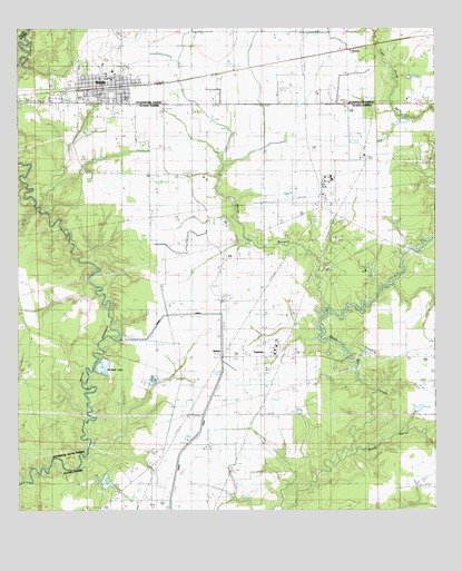
Basile, LA USGS Topographic Map
Click on map above to begin viewing in our Map Viewer.

This topographic map contains these locations and features:
Feature Name Type Latitude Longitude GNIS ID View Map
Acadia - Evangeline Fire Protection DistrictBuildingN30.4847°W92.5927°2691828View Map
Acadia - Evangeline Fire Protection District TepetateBuildingN30.4147°W92.5511°2691697View Map
BasilePopulated PlaceN30.4852°W92.5960°553353View Map
Basile Care CenterBuildingN30.4891°W92.5968°2601032View Map
Basile High SchoolSchoolN30.4873°W92.5972°545677View Map
Basile Police DepartmentBuildingN30.4848°W92.5923°2334034View Map
Basile Post OfficePost OfficeN30.4832°W92.5974°1630283View Map
Basile Volunteer Fire DepartmentBuildingN30.4827°W92.5921°2332409View Map
Bayou BarwickStreamN30.4269°W92.5329°532436View Map
Bayou MalletStreamN30.3880°W92.5290°560020View Map
Berwick CreekStreamN30.4196°W92.5354°1630086View Map
Evangeline Parish Library Basile Branch LibraryBuildingN30.4856°W92.5946°2603058View Map
First Baptist ChurchChurchN30.4885°W92.5959°2601722View Map
Greater Golden Light Baptist ChurchChurchN30.4813°W92.6035°2601824View Map
KBAZ-FM (Basile)TowerN30.4813°W92.5849°1633033View Map
Langley CemeteryCemeteryN30.4360°W92.5840°536330View Map
Mamou CanalCanalN30.4252°W92.5790°536870View Map
Millers Flying ServiceAirportN30.4828°W92.5474°1632608View Map
Mitchell LakeReservoirN30.4125°W92.5999°555340View Map
North Tepetate Oil and Gas FieldOilfieldN30.4533°W92.5360°537751View Map
Parish Governing Authority District 15 (historical)CivilN30.3760°W92.5193°1929857View Map
RedichPopulated PlaceN30.4163°W92.5646°555778View Map
Redich School (historical)SchoolN30.4296°W92.5637°544739View Map
Reed CemeteryCemeteryN30.3783°W92.5974°538550View Map
Reed School (historical)SchoolN30.3766°W92.5899°544740View Map
Saint Augustine Catholic ChurchChurchN30.4879°W92.5985°2602603View Map
Saint Monica ChurchChurchN30.4808°W92.5046°539011View Map
TepetatePopulated PlaceN30.4144°W92.5526°543719View Map
Tepetate Oil and Gas FieldOilfieldN30.4113°W92.5574°539823View Map
Town of BasileCivilN30.4855°W92.6010°2405211View Map
TyronePopulated PlaceN30.4971°W92.5112°541204View Map
UnatexPopulated PlaceN30.4941°W92.5260°543745View Map
W W Stewart Elementary SchoolSchoolN30.4824°W92.6080°545733View Map

Note: Coordinates in the location and feature list above are referenced to NAD83 datum.


Copyright (C) 2008-2024 Ryan Niemi / Sunset Dynamics ... All Rights Reserved