TopoQuest Logo
Do you find TopoQuest useful?
Help keep TopoQuest running and adding new maps/features by donating!
Bitcoin:  19c7KJd3qBynnjoSw5npx9KScwjBe4ifkT
Litecoin:  LXs6TkuXGGXo1vDsWCkWVdjQX94eUKd6ui
Home View Maps Find Maps Find Places Resources & Links


Lequire, Oklahoma Topographic Map

USGS Map Title: Lequire, OK
USGS Map MRC: 35095A1
DRG (GeoTIFF) Download: o35095a1.tif


Neighboring USGS Topographic Map Quads:


  Sans Bois, OK  
35095B2
 

  Lafayette, OK  
35095B1
 

  McCurtain, OK  
35094B8
 

  Kinta, OK  
35095A2
 

  Lequire, OK  
35095A1
 

  McCurtain SW, OK  
35094A8
 

  Panola, OK  
34095H2
 

  Red Oak, OK  
34095H1
 

  Leflore, OK  
34094H8


Map MRC Location:

N36°
W96°
N36°
W95°
H8 H7 H6 H5 H4 H3 H2 H1
G8 G7 G6 G5 G4 G3 G2 G1
F8 F7 F6 F5 F4 F3 F2 F1
E8 E7 E6 E5 E4 E3 E2 E1
D8 D7 D6 D5 D4 D3 D2 D1
C8 C7 C6 C5 C4 C3 C2 C1
B8 B7 B6 B5 B4 B3 B2 B1
A8 A7 A6 A5 A4 A3 A2 A1
N35°
W96°
N35°
W95°

Lequire, OK USGS 1:24K Topographic Map Preview:
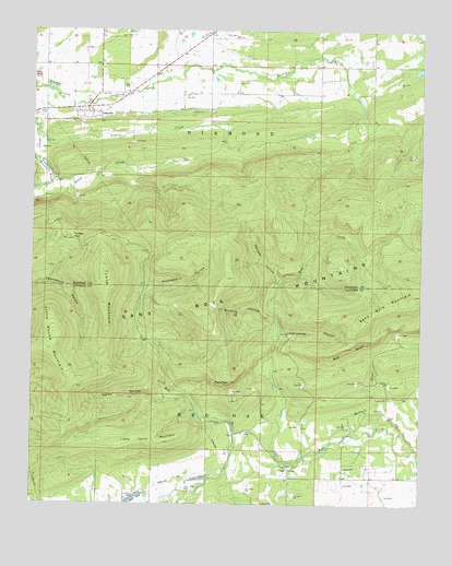
Lequire, OK USGS Topographic Map
Click on map above to begin viewing in our Map Viewer.

This topographic map contains these locations and features:
Feature Name Type Latitude Longitude GNIS ID View Map
Askew HollowValleyN35.0279°W95.0816°1089733View Map
Buzzard HollowValleyN35.0487°W95.0466°1090766View Map
Cowden Laterals Site 12 DamDamN35.1218°W95.0536°1754592View Map
Cowden Laterals Site 12 ReservoirReservoirN35.1218°W95.0536°1754593View Map
Eaton CreekStreamN35.0854°W95.1189°1092467View Map
Huckleberry HollowValleyN35.0573°W95.0888°1093992View Map
Lancaster HollowValleyN35.0448°W95.0444°1094495View Map
LequirePopulated PlaceN35.1045°W95.1075°1094586View Map
Lequire Census Designated PlaceCensusN35.1098°W95.1065°2629928View Map
Lequire Volunteer Fire DepartmentBuildingN35.1040°W95.1081°2657238View Map
Little Round MountainSummitN35.0409°W95.1186°1094821View Map
Little Yancy MountainSummitN35.0165°W95.0822°1094870View Map
LodiPopulated PlaceN35.0093°W95.0422°1100588View Map
Long MountainSummitN35.0612°W95.1022°1094964View Map
McClure CreekStreamN35.0195°W95.0177°1095216View Map
Oknoname 361001 DamDamN35.1034°W95.0486°1751292View Map
Oknoname 361001 ReservoirReservoirN35.1034°W95.0486°1751293View Map
Panther HollowValleyN35.0598°W95.0455°1096416View Map
Red BluffCliffN35.0407°W95.0233°1097080View Map
Ryan PeakSummitN35.0323°W95.0608°1097554View Map
Township of DiamondCivilN35.1029°W95.0627°1824658View Map
Turkey FlatFlatN35.0698°W95.1122°1099052View Map

Note: Coordinates in the location and feature list above are referenced to NAD83 datum.


Copyright (C) 2008-2024 Ryan Niemi / Sunset Dynamics ... All Rights Reserved