TopoQuest Logo
Do you find TopoQuest useful?
Help keep TopoQuest running and adding new maps/features by donating!
Bitcoin:  19c7KJd3qBynnjoSw5npx9KScwjBe4ifkT
Litecoin:  LXs6TkuXGGXo1vDsWCkWVdjQX94eUKd6ui
Home View Maps Find Maps Find Places Resources & Links


Leland, North Carolina Topographic Map

USGS Map Title: Leland, NC
USGS Map MRC: 34078C1
DRG (GeoTIFF) Download: o34078c1.tif


Neighboring USGS Topographic Map Quads:


  Point Caswell, NC  
34078D2
 

  Currie, NC  
34078D1
 

  Rocky Point, NC  
34077D8
 

  Acme, NC  
34078C2
 

  Leland, NC  
34078C1
 

  Castle Hayne, NC  
34077C8
 

  Lewis Swamp, NC  
34078B2
 

  Winnabow, NC  
34078B1
 

  Wilmington, NC  
34077B8


Map MRC Location:

N35°
W79°
N35°
W78°
H8 H7 H6 H5 H4 H3 H2 H1
G8 G7 G6 G5 G4 G3 G2 G1
F8 F7 F6 F5 F4 F3 F2 F1
E8 E7 E6 E5 E4 E3 E2 E1
D8 D7 D6 D5 D4 D3 D2 D1
C8 C7 C6 C5 C4 C3 C2 C1
B8 B7 B6 B5 B4 B3 B2 B1
A8 A7 A6 A5 A4 A3 A2 A1
N34°
W79°
N34°
W78°

Leland, NC USGS 1:24K Topographic Map Preview:
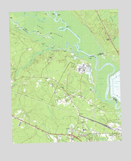
Leland, NC USGS Topographic Map
Click on map above to begin viewing in our Map Viewer.

This topographic map contains these locations and features:
Feature Name Type Latitude Longitude GNIS ID View Map
Alligator BranchStreamN34.2857°W78.1164°980128View Map
Alligator PointCapeN34.3688°W78.1214°980139View Map
Banton BranchStreamN34.2582°W78.0383°980534View Map
Bay BranchStreamN34.3327°W78.0480°980646View Map
Bay BranchStreamN34.3377°W78.0805°980647View Map
Bethel ChurchChurchN34.2529°W78.0567°1000978View Map
Big BaySwampN34.3152°W78.0722°981304View Map
Big IslandCapeN34.3696°W78.0122°1025148View Map
Bill Neal IslandCapeN34.3438°W78.0808°1025159View Map
Black RiverStreamN34.3318°W78.0325°981539View Map
Black River CutGutN34.3582°W78.0633°1026082View Map
Bulldog CutBendN34.3385°W78.0464°982222View Map
Cedar HillPopulated PlaceN34.2846°W78.0305°1025233View Map
Cedar Hill CemeteryCemeteryN34.2829°W78.0178°982864View Map
Cherry Tree ProngStreamN34.2977°W78.0528°983090View Map
Clabber BranchStreamN34.3027°W78.0586°983204View Map
Cowpen BranchStreamN34.2710°W78.1050°1025263View Map
Davis ChapelChurchN34.2566°W78.0089°1000980View Map
Davis YardLocaleN34.2641°W78.0155°1026265View Map
Devils ElbowBendN34.3543°W78.0769°984146View Map
Dollisons LandingLocaleN34.3179°W78.0283°1020002View Map
Dollisons Landing (historical)LocaleN34.3191°W78.0283°1007067View Map
Dollisons SwampSwampN34.3004°W78.0177°984264View Map
Double RunStreamN34.3191°W78.1161°984292View Map
EastbrookPopulated PlaceN34.2760°W78.0486°1006192View Map
Faith ChurchChurchN34.2549°W78.0475°1000979View Map
Field CoveBayN34.3677°W78.0839°1000986View Map
Field CreekGutN34.3741°W78.0925°1026264View Map
Flat BaySwampN34.2541°W78.0683°1004821View Map
George Brown BranchStreamN34.3218°W78.1219°985624View Map
Gibbs CreekStreamN34.3402°W78.0803°985656View Map
Goshen ChurchChurchN34.3132°W78.1122°985844View Map
Grist Mill BranchStreamN34.3513°W78.0869°1025358View Map
Hale Point LandingLocaleN34.3307°W78.0311°1020586View Map
Hall LandingLocaleN34.2999°W78.0347°1020589View Map
Hood CreekStreamN34.3382°W78.0769°1025395View Map
Hood Creek LandingLocaleN34.3385°W78.0772°1020817View Map
Hooper ChapelChurchN34.3118°W78.0825°987031View Map
Hooper HillPopulated PlaceN34.3302°W78.0755°1025396View Map
Indian CreekStreamN34.2838°W78.0067°987346View Map
Johnson ChapelChurchN34.2688°W78.0455°987666View Map
Juniper BaySwampN34.2513°W78.0508°1004823View Map
Lake SuttonReservoirN34.3016°W78.0025°1026081View Map
LelandPopulated PlaceN34.2563°W78.0447°988344View Map
Leland Industrial ParkLocaleN34.2643°W78.0622°2505180View Map
Lincoln High SchoolSchoolN34.2624°W78.0433°1025473View Map
Line CreekStreamN34.3577°W78.0594°1000983View Map
Long BaySwampN34.2803°W78.0810°988879View Map
Long BaySwampN34.3709°W78.0189°988880View Map
Lyon CreekStreamN34.3724°W78.1069°989154View Map
Lyon ThorofareGutN34.3704°W78.0989°1025504View Map
Machine CreekStreamN34.3574°W78.0561°1001090View Map
Magnolia LandingLocaleN34.3307°W78.0480°1021326View Map
Magnolia Landing (historical)LocaleN34.3302°W78.0475°1007069View Map
MalmoPopulated PlaceN34.2660°W78.0989°1025506View Map
Maultbys PointCapeN34.3704°W78.0714°989479View Map
Mill BranchStreamN34.2879°W78.0150°1025525View Map
Mount Calvary ChurchChurchN34.2563°W78.0050°1000981View Map
Mulberry BranchStreamN34.3016°W78.0314°1025568View Map
Mulberry CemeteryCemeteryN34.3138°W78.0480°990772View Map
NavassaPopulated PlaceN34.2554°W78.0075°1025573View Map
Navassa Police DepartmentBuildingN34.2556°W78.0089°2130911View Map
Navassa Post OfficePost OfficeN34.2556°W78.0087°2773893View Map
Navassa Volunteer Fire DepartmentBuildingN34.2564°W78.0097°2638318View Map
Neal BranchStreamN34.3396°W78.0800°1025574View Map
New Hope ChurchChurchN34.2943°W78.0589°1000982View Map
Otter BranchStreamN34.3043°W78.0350°991714View Map
Peachtree LandingLocaleN34.3585°W78.0594°1021843View Map
PhoenixPopulated PlaceN34.2935°W78.0583°1025607View Map
Pine Pole NeckFlatN34.3654°W78.0067°1025612View Map
Raccoon IslandIslandN34.3727°W78.0719°1000984View Map
Rattlesnake BranchStreamN34.3096°W78.1186°1025635View Map
Ready BaySwampN34.2707°W78.0658°993087View Map
Rhyne GraveCemeteryN34.3718°W78.0814°1000985View Map
Richards CrossingLocaleN34.3466°W78.0100°1025647View Map
Roan IslandIslandN34.3541°W78.0694°993408View Map
Roan LandingLocaleN34.3604°W78.1139°1022309View Map
Robinson CemeteryCemeteryN34.2963°W78.0525°993464View Map
Rowel BranchStreamN34.2582°W78.0383°1025660View Map
RoysterLocaleN34.2710°W78.0028°1007068View Map
Singed Pig BaySwampN34.2877°W78.0497°994859View Map
Skipper Hill BranchStreamN34.3218°W78.1219°1025703View Map
Strawberry Hill LandingLocaleN34.3377°W78.0644°1025731View Map
Summersville ChapelChurchN34.3018°W78.0653°995687View Map
Tar LandingLocaleN34.3343°W78.0950°1022882View Map
Town of NavassaCivilN34.2830°W78.0290°2406968View Map
Township of NorthwestCivilN34.2890°W78.1097°1026437View Map
Turkey PointCapeN34.3557°W78.0933°996342View Map
Two Pond BaySwampN34.3586°W78.0049°1025764View Map
Vines BaySwampN34.2893°W78.0447°996634View Map
Wildcat BaySwampN34.2854°W78.0728°997303View Map
Williams CemeteryCemeteryN34.2627°W78.0597°997362View Map

Note: Coordinates in the location and feature list above are referenced to NAD83 datum.


Copyright (C) 2008-2024 Ryan Niemi / Sunset Dynamics ... All Rights Reserved