TopoQuest Logo
Do you find TopoQuest useful?
Help keep TopoQuest running and adding new maps/features by donating!
Bitcoin:  19c7KJd3qBynnjoSw5npx9KScwjBe4ifkT
Litecoin:  LXs6TkuXGGXo1vDsWCkWVdjQX94eUKd6ui
Home View Maps Find Maps Find Places Resources & Links


Leakesville, Mississippi Topographic Map

USGS Map Title: Leakesville, MS
USGS Map MRC: 31088B5
DRG (GeoTIFF) Download: o31088b5.tif


Neighboring USGS Topographic Map Quads:


  Avera, MS  
31088C6
 

  Clark, MS  
31088C5
 

  Fruitdale, AL  
31088C4
 

  Jonathan, MS  
31088B6
 

  Leakesville, MS  
31088B5
 

  Rounsaville, MS  
31088B4
 

  Leakesville SW, MS  
31088A6
 

  Vernal, MS  
31088A5
 

  Brown Town, MS  
31088A4


Map MRC Location:

N32°
W89°
N32°
W88°
H8 H7 H6 H5 H4 H3 H2 H1
G8 G7 G6 G5 G4 G3 G2 G1
F8 F7 F6 F5 F4 F3 F2 F1
E8 E7 E6 E5 E4 E3 E2 E1
D8 D7 D6 D5 D4 D3 D2 D1
C8 C7 C6 C5 C4 C3 C2 C1
B8 B7 B6 B5 B4 B3 B2 B1
A8 A7 A6 A5 A4 A3 A2 A1
N31°
W89°
N31°
W88°

Leakesville, MS USGS 1:24K Topographic Map Preview:
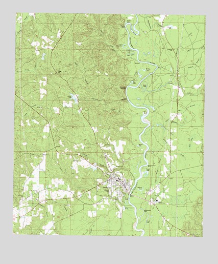
Leakesville, MS USGS Topographic Map
Click on map above to begin viewing in our Map Viewer.

This topographic map contains these locations and features:
Feature Name Type Latitude Longitude GNIS ID View Map
Barnes LakeLakeN31.1760°W88.5434°666533View Map
Black LakeLakeN31.2091°W88.5386°667231View Map
Blakely CreekStreamN31.1563°W88.5450°667262View Map
Buckatunna LakeLakeN31.1365°W88.5405°667738View Map
Bud BluffCliffN31.2230°W88.5422°667755View Map
Cal BranchStreamN31.1910°W88.5225°667910View Map
Calvary Baptist ChurchChurchN31.1860°W88.6023°2596969View Map
Chat High BluffCliffN31.2024°W88.5509°668354View Map
Chickasawhay River Boat RampLocaleN31.1485°W88.5476°2596531View Map
Church of ChristChurchN31.1549°W88.5597°2597093View Map
Church of GodChurchN31.1587°W88.5577°2596435View Map
Churchwell High BluffCliffN31.2088°W88.5514°668488View Map
Clear LakeLakeN31.2276°W88.5493°668578View Map
Coaker BendBendN31.2413°W88.5470°668626View Map
Coaker BluffCliffN31.2432°W88.5528°668627View Map
Coaker BranchStreamN31.2018°W88.5728°668628View Map
Coaker LakeLakeN31.2455°W88.5525°668629View Map
Cutoff LakeLakeN31.1595°W88.5373°669038View Map
Dedoe Lake DamDamN31.1635°W88.5700°680596View Map
DueittPopulated PlaceN31.1507°W88.5345°691826View Map
E S Lee Lake DamDamN31.2235°W88.6067°680621View Map
East Salem CemeteryCemeteryN31.1824°W88.5214°707708View Map
East Salem ChurchChurchN31.1824°W88.5220°669605View Map
Ellen BranchStreamN31.1857°W88.5256°669729View Map
Faith Associate Reformed Presbyterian ChurchChurchN31.1482°W88.5550°2597094View Map
Faulk DitchStreamN31.1293°W88.5386°666096View Map
Faulk LakeLakeN31.1343°W88.5370°669925View Map
Ferry BendBendN31.1949°W88.5386°669953View Map
First Baptist ChurchChurchN31.1557°W88.5522°686447View Map
First United Pentecostal ChurchChurchN31.1570°W88.5620°2596436View Map
Fourmile CreekStreamN31.1924°W88.5414°670135View Map
Gants BluffCliffN31.2205°W88.5311°670312View Map
Gib BaySwampN31.1785°W88.5086°670369View Map
Green CemeteryCemeteryN31.1455°W88.5600°707709View Map
Green CreekStreamN31.2110°W88.5425°670661View Map
Green LakeLakeN31.1432°W88.5504°670674View Map
Greene County Agricultural High School (historical)SchoolN31.1449°W88.6095°686449View Map
Greene County Alternative Learning ProgramSchoolN31.1549°W88.5543°2132773View Map
Greene County Emergency ServicesBuildingN31.1540°W88.5510°2332911View Map
Greene County High SchoolSchoolN31.1416°W88.6007°2132766View Map
Greene County HospitalHospitalN31.1539°W88.5627°707710View Map
Greene County School DistrictSchoolN31.1564°W88.5548°2132770View Map
Greene County Sheriff's OfficeBuildingN31.1539°W88.5510°2332888View Map
Greene County Vocational SchoolSchoolN31.1455°W88.5306°707713View Map
Holy Trinity Catholic ChurchChurchN31.1546°W88.5611°2596437View Map
Jane HillsRangeN31.2460°W88.5653°686451View Map
Jones CreekStreamN31.2243°W88.5442°693638View Map
Lake Luther DamDamN31.2002°W88.5850°680603View Map
LeakesvillePopulated PlaceN31.1557°W88.5578°672343View Map
Leakesville Elementary SchoolSchoolN31.1454°W88.5306°2132771View Map
Leakesville Junior High SchoolSchoolN31.1565°W88.5565°2132772View Map
Leakesville Methodist ChurchChurchN31.1549°W88.5542°686452View Map
Leakesville Missionary Baptist ChurchChurchN31.1536°W88.5610°2596312View Map
Leakesville Police DepartmentBuildingN31.1536°W88.5507°2332899View Map
Leakesville Post OfficePost OfficeN31.1556°W88.5564°2596857View Map
Leakesville Presbyterian ChurchChurchN31.1549°W88.5544°2596438View Map
Leakesville Town HallBuildingN31.1536°W88.5506°2596174View Map
Leakesville Volunteer Fire DepartmentBuildingN31.1574°W88.5593°2332737View Map
Leaksville Lagoon DamDamN31.1402°W88.5517°680590View Map
Lewis CreekStreamN31.2291°W88.5178°672426View Map
Long PondLakeN31.2163°W88.5429°672848View Map
Luther LakeReservoirN31.2025°W88.5861°672964View Map
Magnolia CemeteryCemeteryN31.1502°W88.5620°673067View Map
Martin CreekStreamN31.1380°W88.5447°673183View Map
Mason Chapel Baptist ChurchChurchN31.1593°W88.5598°2596852View Map
McInnis LakeLakeN31.1509°W88.5413°673371View Map
McLeod CreekStreamN31.1835°W88.5395°673402View Map
Meadow BranchStreamN31.1513°W88.5000°666109View Map
Meeting House BluffCliffN31.1649°W88.5370°673461View Map
New Friendship Baptist ChurchChurchN31.1610°W88.5592°2596971View Map
New Hope Baptist ChurchChurchN31.1693°W88.5639°674679View Map
New Providence Baptist ChurchChurchN31.1353°W88.5260°2596170View Map
New Providence CemeteryCemeteryN31.1263°W88.5070°674819View Map
Nichols BranchStreamN31.2121°W88.5175°674915View Map
Oscar Dead RiverLakeN31.2309°W88.5530°675321View Map
Pine Forest Regional Library - Leakesville Public LibraryBuildingN31.1536°W88.5506°2596498View Map
Pine Level Baptist ChurchChurchN31.1496°W88.6089°675860View Map
Pine Level School (historical)SchoolN31.1491°W88.6092°686459View Map
Robertson CemeteryCemeteryN31.2305°W88.5211°676710View Map
Robertson CreekStreamN31.2130°W88.5220°676711View Map
Rounsaville BranchStreamN31.2493°W88.5392°676926View Map
Saluda LakeLakeN31.2302°W88.5499°677308View Map
Silver HillSummitN31.2174°W88.5970°677799View Map
South Mississippi Correctional Institute Fire DepartmentBuildingN31.1773°W88.5990°2332859View Map
South Mississippi Correctional InstitutionBuildingN31.1762°W88.6048°2739791View Map
Still House BranchStreamN31.1516°W88.5464°678292View Map
Supervisor District 1CivilN31.1765°W88.6021°711858View Map
Sweetwater CemeteryCemeteryN31.1452°W88.6195°707722View Map
Sweetwater ChurchChurchN31.1457°W88.6189°678492View Map
Syll BranchStreamN31.1321°W88.5756°678518View Map
Tobe LakeLakeN31.2113°W88.5478°678788View Map
Town of LeakesvilleCivilN31.1544°W88.5580°2405995View Map
Turkey PondLakeN31.2185°W88.5401°678959View Map

Note: Coordinates in the location and feature list above are referenced to NAD83 datum.


Copyright (C) 2008-2024 Ryan Niemi / Sunset Dynamics ... All Rights Reserved