TopoQuest Logo
Do you find TopoQuest useful?
Help keep TopoQuest running and adding new maps/features by donating!
Bitcoin:  19c7KJd3qBynnjoSw5npx9KScwjBe4ifkT
Litecoin:  LXs6TkuXGGXo1vDsWCkWVdjQX94eUKd6ui
Home View Maps Find Maps Find Places Resources & Links


Leadpoint, Washington Topographic Map

USGS Map Title: Leadpoint, WA
USGS Map MRC: 48117H5
DRG (GeoTIFF) Download: o48117h5.tif


Neighboring USGS Topographic Map Quads:


  Boundary, WA  
48117H6
 

  Leadpoint, WA  
48117H5
 

  Abercrombie Mountain, WA  
48117H4
 

  Spirit, WA  
48117G6
 

  Deep Lake, WA  
48117G5
 

  Metaline, WA  
48117G4


Map MRC Location:

N49°
W118°
N49°
W117°
H8 H7 H6 H5 H4 H3 H2 H1
G8 G7 G6 G5 G4 G3 G2 G1
F8 F7 F6 F5 F4 F3 F2 F1
E8 E7 E6 E5 E4 E3 E2 E1
D8 D7 D6 D5 D4 D3 D2 D1
C8 C7 C6 C5 C4 C3 C2 C1
B8 B7 B6 B5 B4 B3 B2 B1
A8 A7 A6 A5 A4 A3 A2 A1
N48°
W118°
N48°
W117°

Leadpoint, WA USGS 1:24K Topographic Map Preview:
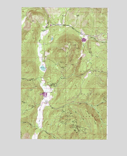
Leadpoint, WA USGS Topographic Map
Click on map above to begin viewing in our Map Viewer.

This topographic map contains these locations and features:
Feature Name Type Latitude Longitude GNIS ID View Map
Admiral Mine and MillMineN48.9271°W117.5766°1515732View Map
Anderson MineMineN48.9194°W117.5916°1515882View Map
Cedar CreekStreamN48.9446°W117.5947°1517539View Map
Cedar Creek SchoolLocaleN48.9780°W117.5908°1517557View Map
Cedar LakeLakeN48.9423°W117.5937°1517571View Map
Cedar LakeReservoirN48.9694°W117.5350°1532423View Map
Copper King MineMineN48.9483°W117.5633°1518086View Map
East Fork Cedar CreekStreamN48.9880°W117.5850°1519089View Map
El Dorado MineMineN48.9460°W117.5489°1519219View Map
Electric PointSummitN48.8830°W117.5455°1534612View Map
Electric Point MineMineN48.8821°W117.5419°1519247View Map
Frank Matney DamDamN48.9699°W117.5377°1532422View Map
Gladstone MineMineN48.8877°W117.5405°1519994View Map
Gladstone MountainSummitN48.8830°W117.5455°1534584View Map
Hartbauer CreekStreamN48.9216°W117.5880°1520578View Map
Hartbauer OrchardAreaN48.9271°W117.5830°1520579View Map
Hungate ClearingFlatN48.9919°W117.5469°1521063View Map
Iroquois CreekStreamN48.9663°W117.5347°1521253View Map
Iroquois MineMineN48.9519°W117.5402°1521254View Map
Jackson MineMineN48.9596°W117.5691°1521315View Map
Joe CreekStreamN48.9771°W117.5433°1521390View Map
Keystone MineMineN48.8816°W117.5300°1521646View Map
Lakeview MineMineN48.9641°W117.5497°1521867View Map
Lead King MineMineN48.8960°W117.5644°1521970View Map
Lead Trust MineMineN48.8974°W117.5591°1521973View Map
LeadpointPopulated PlaceN48.9094°W117.5875°1521975View Map
Lucile MineMineN48.9505°W117.5539°1522563View Map
McKinnon CreekStreamN48.9071°W117.5947°1515704View Map
North Fork Silver CreekStreamN48.9080°W117.5575°1523837View Map
O'Hare CreekStreamN48.9255°W117.5903°1523936View Map
Radio ShaftMineN48.8869°W117.5469°1524799View Map
Ranch View MineMineN48.9621°W117.5416°1524863View Map
Red Iron MineMineN48.8932°W117.5553°1524936View Map
Red Top MineMineN48.9441°W117.5647°1524957View Map
Red Top MountainSummitN48.9613°W117.5400°1524959View Map
Republican CreekStreamN48.8866°W117.5991°1525006View Map
Sherlock CreekStreamN48.8863°W117.5997°1525668View Map
Silver CreekStreamN48.9102°W117.5950°1525758View Map
South Fork Silver CreekStreamN48.9074°W117.5241°1526246View Map
Terry TrailTrailN48.9483°W117.5264°1527017View Map
West Fork Silver CreekStreamN48.9080°W117.5572°1527973View Map
West Side ShaftMineN48.8882°W117.5505°1528002View Map
Wildcat MineMineN48.8913°W117.5503°1528141View Map
Windy RidgeRidgeN48.8974°W117.5216°1528239View Map

Note: Coordinates in the location and feature list above are referenced to NAD83 datum.


Copyright (C) 2008-2024 Ryan Niemi / Sunset Dynamics ... All Rights Reserved