TopoQuest Logo
Do you find TopoQuest useful?
Help keep TopoQuest running and adding new maps/features by donating!
Bitcoin:  19c7KJd3qBynnjoSw5npx9KScwjBe4ifkT
Litecoin:  LXs6TkuXGGXo1vDsWCkWVdjQX94eUKd6ui
Home View Maps Find Maps Find Places Resources & Links


Lauer Reservoir, California Topographic Map

USGS Map Title: Lauer Reservoir, CA
USGS Map MRC: 41120F4
DRG (GeoTIFF) Download: o41120f4.tif


Neighboring USGS Topographic Map Quads:


  McGinty Reservoir, CA  
41120G5
 

  McGinty Point, CA  
41120G4
 

  Sugar Hill, CA  
41120G3
 

  Dead Horse Reservoir, CA  
41120F5
 

  Lauer Reservoir, CA  
41120F4
 

  Davis Creek, CA  
41120F3
 

  Mahogany Ridge, CA  
41120E5
 

  Surprise Station, CA  
41120E4
 

  Payne Peak, CA  
41120E3


Map MRC Location:

N42°
W121°
N42°
W120°
H8 H7 H6 H5 H4 H3 H2 H1
G8 G7 G6 G5 G4 G3 G2 G1
F8 F7 F6 F5 F4 F3 F2 F1
E8 E7 E6 E5 E4 E3 E2 E1
D8 D7 D6 D5 D4 D3 D2 D1
C8 C7 C6 C5 C4 C3 C2 C1
B8 B7 B6 B5 B4 B3 B2 B1
A8 A7 A6 A5 A4 A3 A2 A1
N41°
W121°
N41°
W120°

Lauer Reservoir, CA USGS 1:24K Topographic Map Preview:
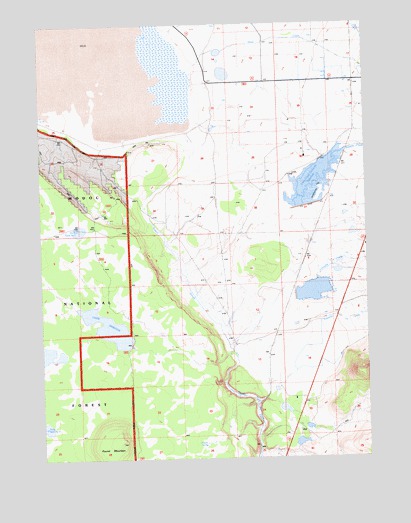
Lauer Reservoir, CA USGS Topographic Map
Click on map above to begin viewing in our Map Viewer.

This topographic map contains these locations and features:
Feature Name Type Latitude Longitude GNIS ID View Map
Bowers SpringSpringN41.6292°W120.4384°257400View Map
Clarke 174 DamDamN41.6899°W120.3827°1663773View Map
Crowder RanchLocaleN41.6454°W120.4100°258944View Map
Curtis-Capik 128 DamDamN41.6716°W120.4027°1663740View Map
Davis Creek Orchards 127-002 DamDamN41.7116°W120.3927°1663739View Map
Davis Creek Orchards ReservoirReservoirN41.7054°W120.3961°252588View Map
Franklin CreekStreamN41.6643°W120.3827°260338View Map
Lauer DamDamN41.6579°W120.4675°1664625View Map
Lauer ReservoirReservoirN41.6628°W120.4756°262371View Map
Leonard Johnson 173-002 DamDamN41.6399°W120.4094°1663772View Map
Linnville CreekStreamN41.6588°W120.4258°262496View Map
Roberts CreekStreamN41.6577°W120.4288°265456View Map
Round MountainSummitN41.6302°W120.4713°267194View Map
Russell SloughStreamN41.6554°W120.4275°265691View Map
Shedd 1121 DamDamN41.6282°W120.4044°1664249View Map
Stock Tank 3ReservoirN41.6551°W120.4993°252590View Map

Note: Coordinates in the location and feature list above are referenced to NAD83 datum.


Copyright (C) 2008-2024 Ryan Niemi / Sunset Dynamics ... All Rights Reserved