TopoQuest Logo
Do you find TopoQuest useful?
Help keep TopoQuest running and adding new maps/features by donating!
Bitcoin:  19c7KJd3qBynnjoSw5npx9KScwjBe4ifkT
Litecoin:  LXs6TkuXGGXo1vDsWCkWVdjQX94eUKd6ui
Home View Maps Find Maps Find Places Resources & Links


Lanier, Georgia Topographic Map

USGS Map Title: Lanier, GA
USGS Map MRC: 32081B5
DRG (GeoTIFF) Download: o32081b5.tif


Neighboring USGS Topographic Map Quads:


  Denmark, GA  
32081C6
 

  Stilson, GA  
32081C5
 

  Guyton, GA  
32081C4
 

  Groveland, GA  
32081B6
 

  Lanier, GA  
32081B5
 

  Eden, GA  
32081B4
 

  Willie, GA  
32081A6
 

  Letford, GA  
32081A5
 

  Meldrim SW, GA  
32081A4


Map MRC Location:

N33°
W82°
N33°
W81°
H8 H7 H6 H5 H4 H3 H2 H1
G8 G7 G6 G5 G4 G3 G2 G1
F8 F7 F6 F5 F4 F3 F2 F1
E8 E7 E6 E5 E4 E3 E2 E1
D8 D7 D6 D5 D4 D3 D2 D1
C8 C7 C6 C5 C4 C3 C2 C1
B8 B7 B6 B5 B4 B3 B2 B1
A8 A7 A6 A5 A4 A3 A2 A1
N32°
W82°
N32°
W81°

Lanier, GA USGS 1:24K Topographic Map Preview:
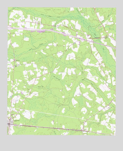
Lanier, GA USGS Topographic Map
Click on map above to begin viewing in our Map Viewer.

This topographic map contains these locations and features:
Feature Name Type Latitude Longitude GNIS ID View Map
Ash BranchStreamN32.2402°W81.5596°354403View Map
Ash Branch ChurchChurchN32.1980°W81.6157°310641View Map
Athens ChurchChurchN32.1391°W81.5362°350492View Map
Bay District Volunteer Fire DepartmentBuildingN32.2350°W81.6135°2603966View Map
Black Creek Golf ClubLocaleN32.1714°W81.5016°2559673View Map
Black Creek School (historical)SchoolN32.1594°W81.5032°350493View Map
Boggy BranchStreamN32.2499°W81.6154°311610View Map
Bryan County ChurchChurchN32.1916°W81.5171°350497View Map
Bryan County CourthouseBuildingN32.1335°W81.6214°2502428View Map
Bryan County Elementary SchoolSchoolN32.1416°W81.6207°2453145View Map
Bryan County High SchoolSchoolN32.1494°W81.6094°350498View Map
Bryan County JailBuildingN32.1345°W81.6185°2502476View Map
Bryan County Middle SchoolSchoolN32.1494°W81.6083°350499View Map
Bryan County Sheriff's OfficeBuildingN32.1345°W81.6186°2733797View Map
Bryan Normal Institute (historical)SchoolN32.1399°W81.6218°350501View Map
Burnsed BridgeBridgeN32.2205°W81.5215°312058View Map
Caney BranchStreamN32.2296°W81.5257°312300View Map
Christ Baptist ChurchChurchN32.1778°W81.5150°2502883View Map
City of PembrokeCivilN32.1455°W81.6186°2404501View Map
Esla School (historical)SchoolN32.2249°W81.6184°334949View Map
Exit 27CrossingN32.2299°W81.6240°1704979View Map
Exit 28CrossingN32.2194°W81.5387°1704980View Map
Faith Harvest Sanctuary ChurchChurchN32.1913°W81.5174°2502787View Map
First Baptist ChurchChurchN32.1385°W81.6237°350510View Map
Georges BranchStreamN32.1808°W81.5357°314563View Map
Groover FordCrossingN32.2391°W81.5693°350361View Map
Jennett IslandFlatN32.2358°W81.5890°316075View Map
LanierPopulated PlaceN32.1299°W81.5368°316637View Map
Lanier ChurchChurchN32.1310°W81.5365°350514View Map
Lanier Elementary SchoolSchoolN32.1430°W81.5273°350515View Map
Lanier Primary SchoolSchoolN32.1421°W81.5276°2453096View Map
Lower Black CreekStreamN32.2388°W81.5401°356370View Map
Mill Creek BaySwampN32.1819°W81.5673°318238View Map
Mill Creek SchoolSchoolN32.1524°W81.5082°318246View Map
Moonshine IslandFlatN32.2258°W81.5787°318425View Map
North Bryan County Fire Department Station 5BuildingN32.1530°W81.5100°2603914View Map
North Side CemeteryCemeteryN32.1444°W81.6221°319674View Map
Patrick BaySwampN32.1727°W81.5859°320262View Map
PembrokePopulated PlaceN32.1360°W81.6221°332632View Map
Pembroke City HallBuildingN32.1382°W81.6221°2502436View Map
Pembroke DivisionCivilN32.1529°W81.5555°1936466View Map
Pembroke Police DepartmentBuildingN32.1354°W81.6235°2733816View Map
Pembroke United Methodist ChurchChurchN32.1374°W81.6212°350527View Map
Pembroke Volunteer Fire DepartmentBuildingN32.1383°W81.6218°2603735View Map
Pembroke Water Pollution Control PlantLocaleN32.1344°W81.6155°2502443View Map
Purvis School (historical)SchoolN32.2024°W81.5509°350528View Map
Scott FordCrossingN32.2169°W81.5732°350445View Map
Stevens Grove CemeteryCemeteryN32.1694°W81.5990°323593View Map
Stevens Grove School (historical)SchoolN32.1669°W81.6129°350533View Map
Upper Black CreekStreamN32.2388°W81.5401°356609View Map
WVAN-TV (Savannah)TowerN32.1469°W81.6179°352864View Map

Note: Coordinates in the location and feature list above are referenced to NAD83 datum.


Copyright (C) 2008-2024 Ryan Niemi / Sunset Dynamics ... All Rights Reserved