TopoQuest Logo
Do you find TopoQuest useful?
Help keep TopoQuest running and adding new maps/features by donating!
Bitcoin:  19c7KJd3qBynnjoSw5npx9KScwjBe4ifkT
Litecoin:  LXs6TkuXGGXo1vDsWCkWVdjQX94eUKd6ui
Home View Maps Find Maps Find Places Resources & Links


Lake View, South Carolina Topographic Map

USGS Map Title: Lake View, SC
USGS Map MRC: 34079C2
DRG (GeoTIFF) Download: o34079c2.tif


Neighboring USGS Topographic Map Quads:


  Dillon East, SC  
34079D3
 

  Gaddysville, NC  
34079D2
 

  Fairmont, NC  
34079D1
 

  Fork, SC  
34079C3
 

  Lake View, SC  
34079C2
 

  Fair Bluff, NC  
34079C1
 

  Mullins, SC  
34079B3
 

  Nichols, SC  
34079B2
 

  Duford, SC  
34079B1


Map MRC Location:

N35°
W80°
N35°
W79°
H8 H7 H6 H5 H4 H3 H2 H1
G8 G7 G6 G5 G4 G3 G2 G1
F8 F7 F6 F5 F4 F3 F2 F1
E8 E7 E6 E5 E4 E3 E2 E1
D8 D7 D6 D5 D4 D3 D2 D1
C8 C7 C6 C5 C4 C3 C2 C1
B8 B7 B6 B5 B4 B3 B2 B1
A8 A7 A6 A5 A4 A3 A2 A1
N34°
W80°
N34°
W79°

Lake View, SC USGS 1:24K Topographic Map Preview:
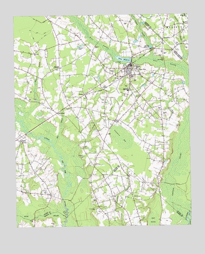
Lake View, SC USGS Topographic Map
Click on map above to begin viewing in our Map Viewer.

This topographic map contains these locations and features:
Feature Name Type Latitude Longitude GNIS ID View Map
A J Poultry FarmLocaleN34.3222°W79.1997°2710702View Map
Allens BridgeBridgeN34.2663°W79.2162°1236073View Map
Alligator CemeteryCemeteryN34.3571°W79.1286°980130View Map
Alligator SwampStreamN34.3454°W79.1289°980144View Map
Bear Swamp Baptist Church CemeteryCemeteryN34.3482°W79.1431°1964690View Map
Bear Swamp ChurchChurchN34.3479°W79.1428°1244997View Map
Big Cowpen SwampStreamN34.3727°W79.1628°981376View Map
Colson BayBasinN34.3718°W79.2403°1248766View Map
Columbus Elementary SchoolSchoolN34.3316°W79.1687°1236085View Map
Columbus High SchoolSchoolN34.3304°W79.1687°1221700View Map
Cooks CemeteryCemeteryN34.3121°W79.1781°1221728View Map
Crutchlow BaySwampN34.3027°W79.1734°1245712View Map
Dillon County Fire Department Station 3BuildingN34.3277°W79.1997°2737355View Map
Dillon County Library System Sadie Carmichael Branch LibraryBuildingN34.3417°W79.1656°2490390View Map
Elvington CemeteryCemeteryN34.3196°W79.2134°1222274View Map
Elvington CemeteryCemeteryN34.3321°W79.1861°1222275View Map
Elvington CemeteryCemeteryN34.3563°W79.1914°1222276View Map
First Baptist Church of Lake ViewChurchN34.3449°W79.1656°1236104View Map
Flowers PondReservoirN34.3569°W79.2019°1222465View Map
Flowers Pond Dam D-0852DamN34.3574°W79.1995°1240076View Map
Ford CemeteryCemeteryN34.3363°W79.1645°1222482View Map
Fork ChurchChurchN34.3010°W79.2456°1247796View Map
Grainger CemeteryCemeteryN34.3049°W79.1831°1222808View Map
Grainger CemeteryCemeteryN34.3165°W79.1436°1222810View Map
Hards BranchStreamN34.2860°W79.2139°1223036View Map
Hayes BranchStreamN34.3135°W79.2448°1223092View Map
Hayestown CemeteryCemeteryN34.3532°W79.2356°1223097View Map
High Hill CrossroadsPopulated PlaceN34.3441°W79.2173°1227917View Map
HolmesvillePopulated PlaceN34.3602°W79.1428°986977View Map
Huggins BridgeBridgeN34.3063°W79.2409°1248770View Map
Joel B Hayes CemeteryCemeteryN34.3162°W79.1614°2727807View Map
John D Page CemeteryCemeteryN34.3202°W79.1470°1223093View Map
Jones CemeteryCemeteryN34.2657°W79.1928°1223634View Map
KemperPopulated PlaceN34.3282°W79.1995°1231443View Map
Kemper Baptist ChurchChurchN34.3260°W79.1984°1236124View Map
Kemper School (historical)SchoolN34.3268°W79.1989°1236125View Map
Kemper School (historical)SchoolN34.3082°W79.1914°1236126View Map
Lake ViewPopulated PlaceN34.3457°W79.1656°1246276View Map
Lake View CemeteryCemeteryN34.3379°W79.1742°1223786View Map
Lake View DivisionCivilN34.3279°W79.2084°1938322View Map
Lake View Elementary SchoolSchoolN34.3313°W79.1681°1236128View Map
Lake View Fire DepartmentBuildingN34.3445°W79.1662°2368375View Map
Lake View High SchoolSchoolN34.3433°W79.1620°1236129View Map
Lake View Middle SchoolSchoolN34.3302°W79.1686°1236130View Map
Lake View Police DepartmentBuildingN34.3446°W79.1661°2334826View Map
Lake View Post OfficePost OfficeN34.3444°W79.1680°2489851View Map
Lake View United Methodist ChurchChurchN34.3429°W79.1681°1236131View Map
Marietta SchoolSchoolN34.3741°W79.1267°989340View Map
May HilltopPopulated PlaceN34.3174°W79.2198°1246567View Map
Meares CemeteryCemeteryN34.2977°W79.2012°1224440View Map
Mile BranchStreamN34.2974°W79.2225°1224492View Map
Miller CemeteryCemeteryN34.3271°W79.1598°1224562View Map
New Zion ChurchChurchN34.3160°W79.1723°1236164View Map
Nichols - Jones CemeteryCemeteryN34.2602°W79.1931°1225048View Map
Nichols Lookout TowerTowerN34.2677°W79.1653°1242445View Map
Page CemeteryCemeteryN34.3552°W79.1270°991781View Map
Pages Mill (historical)LocaleN34.3488°W79.1659°1236169View Map
Pages MillpondReservoirN34.3488°W79.1715°1250012View Map
Pages Millpond Dam D-3600DamN34.3479°W79.1659°1240077View Map
Price CemeteryCemeteryN34.3577°W79.1317°992801View Map
Raft SwampSwampN34.2507°W79.1520°1225736View Map
Ray CemeteryCemeteryN34.3254°W79.2378°1225770View Map
Rogers CemeteryCemeteryN34.3699°W79.1706°1225994View Map
Roziers CemeteryCemeteryN34.3418°W79.1781°1226060View Map
Spiveys CemeteryCemeteryN34.3518°W79.1428°1226793View Map
Spiveys MillpondReservoirN34.3551°W79.1519°1250991View Map
Spiveys Millpond Dam D-3601DamN34.3552°W79.1517°1240079View Map
SquiresPopulated PlaceN34.3015°W79.2450°1227985View Map
Sunny Acres Rest HomeBuildingN34.2699°W79.2453°1236188View Map
Tabernacle Church (historical)ChurchN34.2846°W79.1931°1236189View Map
Thorne Retirement HomeBuildingN34.3441°W79.1734°2489940View Map
Town of Lake ViewCivilN34.3406°W79.1663°2405978View Map
Union CemeteryCemeteryN34.3327°W79.1684°1227284View Map
Union Chapel African Methodist Episcopal ChurchChurchN34.3327°W79.1678°1236190View Map

Note: Coordinates in the location and feature list above are referenced to NAD83 datum.


Copyright (C) 2008-2024 Ryan Niemi / Sunset Dynamics ... All Rights Reserved