TopoQuest Logo
Do you find TopoQuest useful?
Help keep TopoQuest running and adding new maps/features by donating!
Bitcoin:  19c7KJd3qBynnjoSw5npx9KScwjBe4ifkT
Litecoin:  LXs6TkuXGGXo1vDsWCkWVdjQX94eUKd6ui
Home View Maps Find Maps Find Places Resources & Links


Lake Sutherland, Washington Topographic Map

USGS Map Title: Lake Sutherland, WA
USGS Map MRC: 48123A6
DRG (GeoTIFF) Download: o48123a6.tif


Neighboring USGS Topographic Map Quads:


  Disque, WA  
48123B7
 

  Joyce, WA  
48123B6
 

  Angeles Point, WA  
48123B5
 

  Lake Crescent, WA  
48123A7
 

  Lake Sutherland, WA  
48123A6
 

  Elwha, WA  
48123A5
 

  Bogachiel Peak, WA  
47123H7
 

  Mount Carrie, WA  
47123H6
 

  Hurricane Hill, WA  
47123H5


Map MRC Location:

N49°
W124°
N49°
W123°
H8 H7 H6 H5 H4 H3 H2 H1
G8 G7 G6 G5 G4 G3 G2 G1
F8 F7 F6 F5 F4 F3 F2 F1
E8 E7 E6 E5 E4 E3 E2 E1
D8 D7 D6 D5 D4 D3 D2 D1
C8 C7 C6 C5 C4 C3 C2 C1
B8 B7 B6 B5 B4 B3 B2 B1
A8 A7 A6 A5 A4 A3 A2 A1
N48°
W124°
N48°
W123°

Lake Sutherland, WA USGS 1:24K Topographic Map Preview:
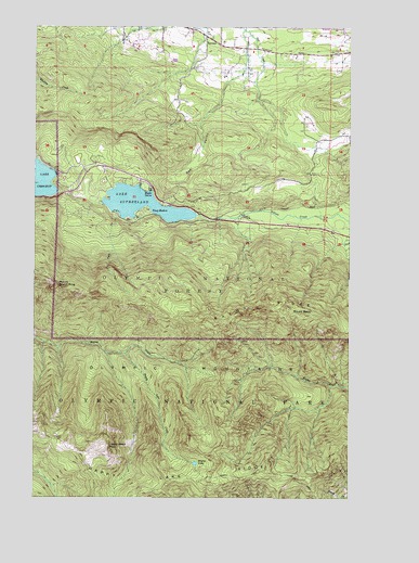
Lake Sutherland, WA USGS Topographic Map
Click on map above to begin viewing in our Map Viewer.

This topographic map contains these locations and features:
Feature Name Type Latitude Longitude GNIS ID View Map
Baldy RidgeRidgeN48.0452°W123.6847°1516103View Map
Bear ValleyFlatN48.0912°W123.6846°1516296View Map
Big Andy AirportAirportN48.0974°W123.6419°1533891View Map
Clallam County District 4 Station 2BuildingN48.1174°W123.6349°2619698View Map
Clallam County Fire District 2 Station 24 - Shadow MountainBuildingN48.0855°W123.7115°2643825View Map
East BeachLocaleN48.0862°W123.7430°1530303View Map
East Beach Picnic AreaLocaleN48.0854°W123.7410°1529537View Map
Falls CreekStreamN48.0759°W123.7188°1519454View Map
Happy LakeLakeN48.0090°W123.6870°1520525View Map
Happy Lake CreekStreamN48.0384°W123.7149°1520526View Map
Happy Lake RidgeRidgeN48.0041°W123.6823°1520527View Map
Happy Lake Ridge TrailTrailN48.0045°W123.6471°1520528View Map
Lake SutherlandLakeN48.0779°W123.7086°1526808View Map
Lizard Head PeakSummitN48.0118°W123.7222°1522333View Map
Maple GrovePopulated PlaceN48.0812°W123.7052°1522694View Map
Mount BaldySummitN48.0485°W123.6438°1516106View Map
Mount Storm KingSummitN48.0553°W123.7408°1526599View Map
RamapoPopulated PlaceN48.1215°W123.6830°1524849View Map
Shadow Mountain Recreational Vehicle ParkLocaleN48.0861°W123.7106°2608266View Map
Snug HarborPopulated PlaceN48.0751°W123.7030°1526063View Map

Note: Coordinates in the location and feature list above are referenced to NAD83 datum.


Copyright (C) 2008-2024 Ryan Niemi / Sunset Dynamics ... All Rights Reserved