TopoQuest Logo
Do you find TopoQuest useful?
Help keep TopoQuest running and adding new maps/features by donating!
Bitcoin:  19c7KJd3qBynnjoSw5npx9KScwjBe4ifkT
Litecoin:  LXs6TkuXGGXo1vDsWCkWVdjQX94eUKd6ui
Home View Maps Find Maps Find Places Resources & Links


Lake Mills, Wisconsin Topographic Map

USGS Map Title: Lake Mills, WI
USGS Map MRC: 43088A8
DRG (GeoTIFF) Download: o43088a8.tif


Neighboring USGS Topographic Map Quads:


  Marshall, WI  
43089B1
 

  Waterloo, WI  
43088B8
 

  Richwood, WI  
43088B7
 

  Deerfield, WI  
43089A1
 

  Lake Mills, WI  
43088A8
 

  Jefferson, WI  
43088A7
 

  Rockdale, WI  
42089H1
 

  Busseyville, WI  
42088H8
 

  Fort Atkinson, WI  
42088H7


Map MRC Location:

N44°
W89°
N44°
W88°
H8 H7 H6 H5 H4 H3 H2 H1
G8 G7 G6 G5 G4 G3 G2 G1
F8 F7 F6 F5 F4 F3 F2 F1
E8 E7 E6 E5 E4 E3 E2 E1
D8 D7 D6 D5 D4 D3 D2 D1
C8 C7 C6 C5 C4 C3 C2 C1
B8 B7 B6 B5 B4 B3 B2 B1
A8 A7 A6 A5 A4 A3 A2 A1
N43°
W89°
N43°
W88°

Lake Mills, WI USGS 1:24K Topographic Map Preview:
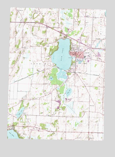
Lake Mills, WI USGS Topographic Map
Click on map above to begin viewing in our Map Viewer.

This topographic map contains these locations and features:
Feature Name Type Latitude Longitude GNIS ID View Map
Badger SchoolSchoolN43.0875°W88.9804°1561077View Map
Bean LakeLakeN43.0582°W88.9446°1561338View Map
Bean Lake State Natural AreaParkN43.0597°W88.9421°1988736View Map
Breezy KnollPopulated PlaceN43.0086°W88.9664°2515654View Map
Brick Street SchoolSchoolN43.0528°W88.9534°1562191View Map
City of Lake MillsCivilN43.0776°W88.9042°1583514View Map
Faville Grove SchoolSchoolN43.1178°W88.9018°1564883View Map
Flanagan SchoolSchoolN43.0025°W88.8937°1565055View Map
Ha-Rail AirportAirportN43.0361°W88.8932°1581029View Map
Harvey SchoolSchoolN43.0333°W88.8937°1566115View Map
Hoopers DamDamN43.0950°W88.8768°1791930View Map
Hoopers MillPopulated PlaceN43.0967°W88.8815°1566668View Map
Hoopers Millpond 16ReservoirN43.0950°W88.8768°1791931View Map
Hope LakeLakeN43.0249°W88.9841°1566683View Map
Lake MillsPopulated PlaceN43.0814°W88.9118°1567742View Map
Lake Mills Elementary SchoolSchoolN43.0874°W88.9074°1840416View Map
Lake Mills Emergency Medical ServicesBuildingN43.0790°W88.9038°2698424View Map
Lake Mills Fire DepartmentBuildingN43.0783°W88.9145°2697503View Map
Lake Mills High SchoolSchoolN43.0708°W88.9114°1840397View Map
Lake Mills Middle SchoolSchoolN43.0822°W88.9150°1840398View Map
Lake Mills Police DepartmentBuildingN43.0784°W88.9112°2759693View Map
Lake Mills Post OfficePost OfficeN43.0812°W88.9091°1840399View Map
Lake Mills Town Police DepartmentBuildingN43.0653°W88.9142°2759959View Map
Lake Mills Wastewater Treatment PlantLocaleN43.0805°W88.8965°2729073View Map
Lake RipleyPopulated PlaceN43.0058°W88.9862°1867659View Map
Lake RipleyLakeN43.0010°W88.9917°1572336View Map
Lake Ripley Census Designated PlaceCensusN43.0045°W88.9829°2393083View Map
Lakeside Lutheran High SchoolSchoolN43.0681°W88.9179°1840400View Map
Lakeside ParkParkN43.0792°W88.9184°1567782View Map
Mankowski QuarryMineN43.0072°W88.9603°2633859View Map
Mud LakeLakeN43.0457°W88.9218°1569907View Map
Newville CemeteryCemeteryN43.1072°W88.9443°1570271View Map
North Oakland CemeteryCemeteryN43.0021°W88.9093°1570473View Map
Oakland 3 WR 1801 DamDamN43.0000°W88.9701°1793366View Map
Oakland Police DepartmentBuildingN43.0075°W88.9681°2759822View Map
Perch LakeLakeN43.0487°W88.9353°2761918View Map
Plainview SchoolSchoolN43.1072°W88.9521°1571579View Map
Rock LakeLakeN43.0783°W88.9304°1572454View Map
Rock Lake CemeteryCemeteryN43.0888°W88.9137°1572462View Map
Saint Paul Evangelical Lutheran SchoolSchoolN43.0839°W88.9140°1573498View Map
Saint Paul Evangelical Lutheran SchoolSchoolN43.0604°W88.9072°2716673View Map
Stony Brook SchoolSchoolN43.1222°W88.9909°1574943View Map
Town of Lake MillsCivilN43.0656°W88.9571°1583515View Map
Townline SchoolSchoolN43.0225°W88.9457°1575552View Map

Note: Coordinates in the location and feature list above are referenced to NAD83 datum.


Copyright (C) 2008-2024 Ryan Niemi / Sunset Dynamics ... All Rights Reserved