TopoQuest Logo
Do you find TopoQuest useful?
Help keep TopoQuest running and adding new maps/features by donating!
Bitcoin:  19c7KJd3qBynnjoSw5npx9KScwjBe4ifkT
Litecoin:  LXs6TkuXGGXo1vDsWCkWVdjQX94eUKd6ui
Home View Maps Find Maps Find Places Resources & Links


Lake Lure, North Carolina Topographic Map

USGS Map Title: Lake Lure, NC
USGS Map MRC: 35082D2
DRG (GeoTIFF) Download: o35082d2.tif


Neighboring USGS Topographic Map Quads:


  Black Mountain, NC  
35082E3
 

  Moffitt Hill, NC  
35082E2
 

  Sugar Hill, NC  
35082E1
 

  Bat Cave, NC  
35082D3
 

  Lake Lure, NC  
35082D2
 

  Shingle Hollow, NC  
35082D1
 

  Cliffield Mountain, NC  
35082C3
 

  Mill Spring, NC  
35082C2
 

  Pea Ridge, NC  
35082C1


Map MRC Location:

N36°
W83°
N36°
W82°
H8 H7 H6 H5 H4 H3 H2 H1
G8 G7 G6 G5 G4 G3 G2 G1
F8 F7 F6 F5 F4 F3 F2 F1
E8 E7 E6 E5 E4 E3 E2 E1
D8 D7 D6 D5 D4 D3 D2 D1
C8 C7 C6 C5 C4 C3 C2 C1
B8 B7 B6 B5 B4 B3 B2 B1
A8 A7 A6 A5 A4 A3 A2 A1
N35°
W83°
N35°
W82°

Lake Lure, NC USGS 1:24K Topographic Map Preview:
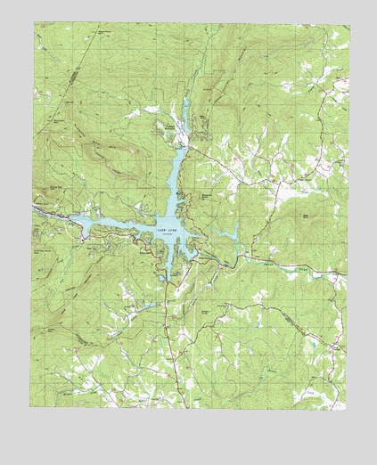
Lake Lure, NC USGS Topographic Map
Click on map above to begin viewing in our Map Viewer.

This topographic map contains these locations and features:
Feature Name Type Latitude Longitude GNIS ID View Map
Bald Mountain LakeReservoirN35.4700°W82.1894°999000View Map
Bald Mountain Lake DamDamN35.4651°W82.1882°999001View Map
Bills CreekPopulated PlaceN35.4487°W82.1459°1019173View Map
Bills Creek Baptist CemeteryCemeteryN35.4516°W82.1411°2779009View Map
Bills Creek Baptist ChurchChurchN35.4512°W82.1418°1008412View Map
Bills Creek Volunteer Fire Department Station 1BuildingN35.4486°W82.1517°2639649View Map
Bills Creek Volunteer Fire Department Station 2BuildingN35.4824°W82.1367°2639636View Map
Bills MountainSummitN35.4373°W82.1434°981489View Map
Bob (historical)Populated PlaceN35.4112°W82.2096°1023605View Map
Buffalo CreekStreamN35.4593°W82.1890°1009795View Map
Buzzards RoostSummitN35.4435°W82.1834°1023865View Map
Camp LurecrestLocaleN35.4190°W82.1921°1001005View Map
Camp OcconeecheePopulated PlaceN35.4087°W82.2084°1019497View Map
Cane CreekStreamN35.4165°W82.1973°1023875View Map
Cane Creek ChurchChurchN35.4093°W82.1954°1019509View Map
Cane Creek Church GraveyardCemeteryN35.4091°W82.1951°2779008View Map
Cane Creek MountainSummitN35.4026°W82.2390°982600View Map
Carolina MountainsPopulated PlaceN35.4496°W82.1721°1008418View Map
Chimney RockPopulated PlaceN35.4393°W82.2465°1027392View Map
Chimney Rock Baptist ChurchChurchN35.4379°W82.2307°1008422View Map
Chimney Rock Post OfficePost OfficeN35.4394°W82.2470°2774324View Map
Chimney Rock Volunteer Fire DepartmentBuildingN35.4408°W82.2481°2639647View Map
Cooper Gap ChurchChurchN35.3785°W82.1982°983505View Map
DeerfieldPopulated PlaceN35.4765°W82.1943°1008426View Map
Fairfield MountainSummitN35.4693°W82.1990°1001007View Map
Fairfield MountainsPopulated PlaceN35.4657°W82.1915°1008428View Map
Fairfield Mountains Volunteer Fire Department Station 1BuildingN35.4625°W82.1883°2638389View Map
Fairfield Volunteer Fire Department Station 2BuildingN35.4204°W82.1878°2639644View Map
Golf EstatesPopulated PlaceN35.4648°W82.1998°1008436View Map
Grassy KnobSummitN35.4048°W82.1826°1020509View Map
Grassy Knob ChurchChurchN35.4093°W82.1723°985969View Map
Grassy Knob Church CemeteryCemeteryN35.4089°W82.1725°2779007View Map
Hickory Nut GorgeValleyN35.4328°W82.2017°2704343View Map
Hickory Nut Gorge Volunteer Emergency Medical Services and RescueBuildingN35.4254°W82.1622°2720515View Map
Hickory Nut Lower DamDamN35.4301°W82.1682°998962View Map
Hickory Nut Lower LakeReservoirN35.4301°W82.1682°998963View Map
Hickory Nut Upper DamDamN35.4318°W82.1732°998967View Map
Hickory Nut Upper LakeReservoirN35.4314°W82.1697°998966View Map
Hickorynut GapGapN35.4260°W82.1843°986722View Map
Island CreekStreamN35.4218°W82.1748°1001006View Map
Judes GapGapN35.4007°W82.2451°1001082View Map
Lake LurePopulated PlaceN35.4279°W82.2048°1021079View Map
Lake LureReservoirN35.4359°W82.1998°989133View Map
Lake Lure DamDamN35.4260°W82.1841°998959View Map
Lake Lure Municipal Golf CourseLocaleN35.4162°W82.1898°1008447View Map
Lake Lure Police DepartmentBuildingN35.4356°W82.2321°2769560View Map
Lake Lure Post OfficePost OfficeN35.4310°W82.2207°2773971View Map
Occoneechee LakeReservoirN35.4084°W82.2028°998942View Map
Occoneechee Lake DamDamN35.4101°W82.1998°998943View Map
Pool CreekStreamN35.4301°W82.2287°992659View Map
Poplar GrovePopulated PlaceN35.3843°W82.1318°1022041View Map
Quail RidgePopulated PlaceN35.4585°W82.1984°1008460View Map
RiverbendPopulated PlaceN35.4293°W82.1696°1008461View Map
Rock Spring ChurchChurchN35.3973°W82.1282°1023583View Map
Rock SpringsPopulated PlaceN35.3957°W82.1307°1024271View Map
Rock Springs CemeteryCemeteryN35.3969°W82.1287°2779006View Map
Round Top MountainSummitN35.4457°W82.2443°1022429View Map
Rumbling Bald MountainSummitN35.4598°W82.2268°993799View Map
Rutherford County Emergency Medical Services Station 2BuildingN35.4253°W82.1622°2720321View Map
Saint Johns Baptist Church CemeteryCemeteryN35.4550°W82.1274°2779010View Map
Saint Johns ChurchChurchN35.4551°W82.1279°993947View Map
Shumont MountainSummitN35.4679°W82.2429°994782View Map
The Mountains DamDamN35.4701°W82.1932°999006View Map
The Mountains LakeReservoirN35.4701°W82.1932°999005View Map
The PoolsLakeN35.4265°W82.2343°1008459View Map
Town of Lake LureCivilN35.4403°W82.2063°2405973View Map
Township of Chimney RockCivilN35.4532°W82.1867°1027156View Map
UreePopulated PlaceN35.4251°W82.1671°996565View Map
Weed Patch MountainSummitN35.4965°W82.2254°1024396View Map
Whiteside FordCrossingN35.4193°W82.1282°1008476View Map
Wolf CreekStreamN35.4246°W82.2346°997526View Map
Youngs MountainSummitN35.4773°W82.1746°1024419View Map
Youngs MountainPopulated PlaceN35.4648°W82.1846°1008478View Map

Note: Coordinates in the location and feature list above are referenced to NAD83 datum.


Copyright (C) 2008-2024 Ryan Niemi / Sunset Dynamics ... All Rights Reserved