TopoQuest Logo
Do you find TopoQuest useful?
Help keep TopoQuest running and adding new maps/features by donating!
Bitcoin:  19c7KJd3qBynnjoSw5npx9KScwjBe4ifkT
Litecoin:  LXs6TkuXGGXo1vDsWCkWVdjQX94eUKd6ui
Home View Maps Find Maps Find Places Resources & Links


Lake Como, Mississippi Topographic Map

USGS Map Title: Lake Como, MS
USGS Map MRC: 31089H2
DRG (GeoTIFF) Download: o31089h2.tif


Neighboring USGS Topographic Map Quads:


  Louin, MS  
32089A3
 

  Montrose South, MS  
32089A2
 

  Paulding, MS  
32089A1
 

  Bay Springs, MS  
31089H3
 

  Lake Como, MS  
31089H2
 

  Waldrup, MS  
31089H1
 

  Soso, MS  
31089G3
 

  Moss, MS  
31089G2
 

  Sandersville, MS  
31089G1


Map MRC Location:

N32°
W90°
N32°
W89°
H8 H7 H6 H5 H4 H3 H2 H1
G8 G7 G6 G5 G4 G3 G2 G1
F8 F7 F6 F5 F4 F3 F2 F1
E8 E7 E6 E5 E4 E3 E2 E1
D8 D7 D6 D5 D4 D3 D2 D1
C8 C7 C6 C5 C4 C3 C2 C1
B8 B7 B6 B5 B4 B3 B2 B1
A8 A7 A6 A5 A4 A3 A2 A1
N31°
W90°
N31°
W89°

Lake Como, MS USGS 1:24K Topographic Map Preview:
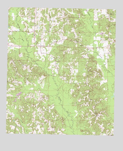
Lake Como, MS USGS Topographic Map
Click on map above to begin viewing in our Map Viewer.

This topographic map contains these locations and features:
Feature Name Type Latitude Longitude GNIS ID View Map
AcmePopulated PlaceN31.9677°W89.1734°691658View Map
Beat Line ChurchChurchN31.9829°W89.2195°666679View Map
Bethlehem Primitive Baptist ChurchChurchN31.9671°W89.1937°666995View Map
Blue RidgePopulated PlaceN31.8960°W89.1473°686632View Map
Blue Ridge ChurchChurchN31.8952°W89.1456°667319View Map
Enanon CemeteryCemeteryN31.9582°W89.1873°669775View Map
Enon CemeteryCemeteryN31.9715°W89.1323°707794View Map
Enon Missionary Baptist ChurchChurchN31.9721°W89.1331°669776View Map
Girl Scout Camp Lake DamDamN31.9752°W89.1934°680968View Map
Hal Volunteer Fire and RescueBuildingN31.9681°W89.1873°2668045View Map
Holder ChurchChurchN31.9635°W89.1642°671283View Map
Holder Lookout TowerTowerN31.9668°W89.1712°711248View Map
Hopewell ChurchChurchN31.8971°W89.1481°671418View Map
Hosey Lake DamDamN31.9152°W89.2217°680941View Map
Ishee Lake DamDamN31.9785°W89.1434°680969View Map
Lake ComoPopulated PlaceN31.9624°W89.2126°691993View Map
Lake Como Baptist ChurchChurchN31.9649°W89.2145°686638View Map
Lake Como CemeteryCemeteryN31.9651°W89.2162°707807View Map
M L Husband Lake DamDamN31.9168°W89.2417°680944View Map
Mount Pleasant CemeteryCemeteryN31.8818°W89.1970°674211View Map
Norman Lake DamDamN31.9102°W89.2384°680939View Map
Piney BranchStreamN31.9574°W89.2281°694397View Map
Piney CreekStreamN31.9557°W89.2262°694399View Map
Piney Grove ChurchChurchN31.9477°W89.1906°675895View Map
Saint John ChurchChurchN31.9296°W89.2281°677052View Map
Supervisor District 1CivilN31.9640°W89.1567°711904View Map
Terry CemeteryCemeteryN31.9351°W89.1553°678647View Map
Thigpen FieldAirportN31.9533°W89.2342°680330View Map
VernonPopulated PlaceN31.9102°W89.1534°692294View Map
Vrue (historical)Populated PlaceN31.9952°W89.1681°686649View Map
Walters ChapelChurchN31.9954°W89.1323°679311View Map

Note: Coordinates in the location and feature list above are referenced to NAD83 datum.


Copyright (C) 2008-2024 Ryan Niemi / Sunset Dynamics ... All Rights Reserved