TopoQuest Logo
Do you find TopoQuest useful?
Help keep TopoQuest running and adding new maps/features by donating!
Bitcoin:  19c7KJd3qBynnjoSw5npx9KScwjBe4ifkT
Litecoin:  LXs6TkuXGGXo1vDsWCkWVdjQX94eUKd6ui
Home View Maps Find Maps Find Places Resources & Links


Lake City, South Dakota Topographic Map

USGS Map Title: Lake City, SD
USGS Map MRC: 45097F4
DRG (GeoTIFF) Download: o45097f4.tif


Neighboring USGS Topographic Map Quads:


  Kidder SE, SD  
45097G5
 

  Hillhead, SD  
45097G4
 

  Veblen, SD  
45097G3
 

  Twomile Lake, SD  
45097F5
 

  Lake City, SD  
45097F4
 

  South Red Iron Lake, SD  
45097F3
 

  Stangland Slough, SD  
45097E5
 

  Eden, SD  
45097E4
 

  Piyas Lake, SD  
45097E3


Map MRC Location:

N46°
W98°
N46°
W97°
H8 H7 H6 H5 H4 H3 H2 H1
G8 G7 G6 G5 G4 G3 G2 G1
F8 F7 F6 F5 F4 F3 F2 F1
E8 E7 E6 E5 E4 E3 E2 E1
D8 D7 D6 D5 D4 D3 D2 D1
C8 C7 C6 C5 C4 C3 C2 C1
B8 B7 B6 B5 B4 B3 B2 B1
A8 A7 A6 A5 A4 A3 A2 A1
N45°
W98°
N45°
W97°

Lake City, SD USGS 1:24K Topographic Map Preview:
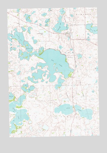
Lake City, SD USGS Topographic Map
Click on map above to begin viewing in our Map Viewer.

This topographic map contains these locations and features:
Feature Name Type Latitude Longitude GNIS ID View Map
Bullhead LakeLakeN45.7126°W97.4720°1254156View Map
Cattail LakeLakeN45.6469°W97.4879°1265147View Map
Chokecherry Island SloughLakeN45.7269°W97.4507°1254354View Map
Cottonwood LakeLakeN45.7324°W97.4270°1265630View Map
Fourmile LakeLakeN45.7228°W97.4879°1265223View Map
Lake CityPopulated PlaceN45.7252°W97.4145°1256013View Map
Lake City CemeteryCemeteryN45.7197°W97.3912°1256014View Map
Lake City Post OfficePost OfficeN45.7229°W97.4136°2710485View Map
Little Cottonwood LakeLakeN45.7377°W97.4451°1256155View Map
Long LakeLakeN45.7282°W97.3796°1256231View Map
Lost LakeLakeN45.6717°W97.4730°1256252View Map
Marshall County Waterfowl Production AreaParkN45.7490°W97.4340°2765394View Map
Roy LakeLakeN45.6977°W97.4407°1257510View Map
Roy Lake State Park Number 1ParkN45.7088°W97.4532°1257511View Map
Roy Lake State Park Number 2ParkN45.7005°W97.4190°1257512View Map
Saint Joseph CemeteryCemeteryN45.7188°W97.3981°1257639View Map
Sixmile LakeLakeN45.7381°W97.4695°1258097View Map
Stink LakesLakeN45.6479°W97.3958°1258353View Map
Sunnyside (historical)LocaleN45.7475°W97.3920°1263213View Map
Town of Lake CityCivilN45.7249°W97.4138°1267449View Map
Township of LakeCivilN45.7055°W97.4182°1267754View Map
Township of Lake CityCivilN45.6819°W97.3834°1267757View Map

Note: Coordinates in the location and feature list above are referenced to NAD83 datum.


Copyright (C) 2008-2024 Ryan Niemi / Sunset Dynamics ... All Rights Reserved