TopoQuest Logo
Do you find TopoQuest useful?
Help keep TopoQuest running and adding new maps/features by donating!
Bitcoin:  19c7KJd3qBynnjoSw5npx9KScwjBe4ifkT
Litecoin:  LXs6TkuXGGXo1vDsWCkWVdjQX94eUKd6ui
Home View Maps Find Maps Find Places Resources & Links


Lafayette, Texas Topographic Map

USGS Map Title: Lafayette, TX
USGS Map MRC: 32094H7
DRG (GeoTIFF) Download: o32094h7.tif


Neighboring USGS Topographic Map Quads:


  Harvard, TX  
33094A8
 

  Cason, TX  
33094A7
 

  Daingerfield, TX  
33094A6
 

  Pittsburg, TX  
32094H8
 

  Lafayette, TX  
32094H7
 

  Lone Star, TX  
32094H6
 

  Bettie, TX  
32094G8
 

  Coffeeville, TX  
32094G7
 

  Ore City, TX  
32094G6


Map MRC Location:

N33°
W95°
N33°
W94°
H8 H7 H6 H5 H4 H3 H2 H1
G8 G7 G6 G5 G4 G3 G2 G1
F8 F7 F6 F5 F4 F3 F2 F1
E8 E7 E6 E5 E4 E3 E2 E1
D8 D7 D6 D5 D4 D3 D2 D1
C8 C7 C6 C5 C4 C3 C2 C1
B8 B7 B6 B5 B4 B3 B2 B1
A8 A7 A6 A5 A4 A3 A2 A1
N32°
W95°
N32°
W94°

Lafayette, TX USGS 1:24K Topographic Map Preview:
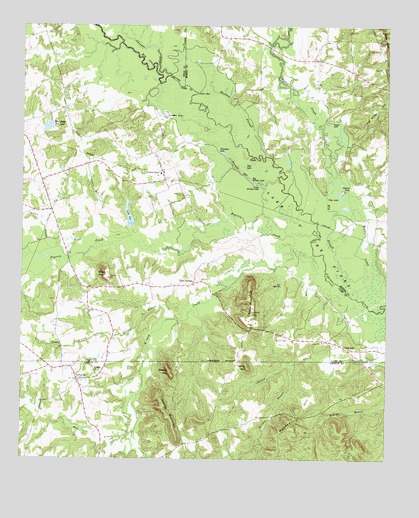
Lafayette, TX USGS Topographic Map
Click on map above to begin viewing in our Map Viewer.

This topographic map contains these locations and features:
Feature Name Type Latitude Longitude GNIS ID View Map
Adams MountainSummitN32.8818°W94.8216°1329213View Map
Antioch ChurchChurchN32.9182°W94.8524°1329609View Map
Big Brushy LakeLakeN32.9550°W94.7962°1330571View Map
Big SloughGutN32.9429°W94.7677°1330651View Map
Boggy CreekStreamN32.9224°W94.7622°1331012View Map
Burton SloughStreamN32.9626°W94.7913°1331730View Map
Center PointPopulated PlaceN32.9643°W94.8302°2034805View Map
Center PointLocaleN32.9579°W94.8266°1332535View Map
Clayton LakeLakeN32.9546°W94.7659°1332917View Map
Clear LakeLakeN32.9514°W94.7666°1332948View Map
Couch MountainSummitN32.9265°W94.7966°1333496View Map
County LineLocaleN32.9065°W94.7630°1333506View Map
Dixon CreekStreamN32.8810°W94.8408°1334415View Map
Dunagan LakeLakeN32.9741°W94.8267°1334762View Map
Ellison BranchStreamN32.9154°W94.8222°1335333View Map
Flanagan LakeLakeN32.9638°W94.8072°1335887View Map
Flanagan RunStreamN32.9551°W94.7863°1335888View Map
Greasy CreekStreamN32.9343°W94.7752°1336893View Map
Helms MountainSummitN32.9018°W94.7974°1337582View Map
Holiday BranchStreamN32.9024°W94.7822°1337935View Map
Holiday HillSummitN32.8821°W94.7874°1337936View Map
Holly SpringsPopulated PlaceN32.9257°W94.8160°1337960View Map
Joplin HoleBendN32.9812°W94.8108°1338873View Map
Kitchen BranchStreamN32.9354°W94.8649°1339168View Map
LaFayettePopulated PlaceN32.8985°W94.8560°1378544View Map
Lafayette Volunteer Fire DepartmentBuildingN32.9011°W94.8581°2655416View Map
Lake SueReservoirN32.9455°W94.8387°1348027View Map
Lake Sue DamDamN32.9418°W94.8369°1862118View Map
Lee SpringsSpringN32.9254°W94.7858°1339792View Map
Little Brushy LakeLakeN32.9536°W94.7933°1340034View Map
Massey MountainSummitN32.9007°W94.8241°1341062View Map
Mount Rose ChurchChurchN32.9004°W94.8499°1342112View Map
Pat Miller HillSummitN32.9774°W94.7510°1343651View Map
Pine Ridge Club DamDamN32.9718°W94.8652°1862120View Map
Pine Ridge Club LakeReservoirN32.9710°W94.8666°1344071View Map
Pleasant Grove CemeteryCemeteryN32.8987°W94.8733°1344189View Map
Prairie CreekStreamN32.9407°W94.7752°1344496View Map
Rafe LakeLakeN32.9593°W94.7985°1344698View Map
Slaton CemeteryCemeteryN32.9807°W94.7599°1347222View Map
Slaton LakeLakeN32.9722°W94.7702°1347223View Map
South Greasy CreekStreamN32.8935°W94.8349°1347468View Map
Stoker BranchStreamN32.9107°W94.8485°1347952View Map
Swauano CreekStreamN32.9857°W94.8247°1376349View Map
West Greasy CreekStreamN32.8935°W94.8347°1349744View Map
Wilks MountainSummitN32.9290°W94.8466°1350102View Map

Note: Coordinates in the location and feature list above are referenced to NAD83 datum.


Copyright (C) 2008-2024 Ryan Niemi / Sunset Dynamics ... All Rights Reserved