TopoQuest Logo
Do you find TopoQuest useful?
Help keep TopoQuest running and adding new maps/features by donating!
Bitcoin:  19c7KJd3qBynnjoSw5npx9KScwjBe4ifkT
Litecoin:  LXs6TkuXGGXo1vDsWCkWVdjQX94eUKd6ui
Home View Maps Find Maps Find Places Resources & Links


La Grange, North Carolina Topographic Map

USGS Map Title: La Grange, NC
USGS Map MRC: 35077C7
DRG (GeoTIFF) Download: o35077c7.tif


Neighboring USGS Topographic Map Quads:


  Northeast Goldsboro, NC  
35077D8
 

  Jason, NC  
35077D7
 

  Snow Hill, NC  
35077D6
 

  Southeast Goldsboro, NC  
35077C8
 

  La Grange, NC  
35077C7
 

  Falling Creek, NC  
35077C6
 

  Williams, NC  
35077B8
 

  Seven Springs, NC  
35077B7
 

  Deep Run, NC  
35077B6


Map MRC Location:

N36°
W78°
N36°
W77°
H8 H7 H6 H5 H4 H3 H2 H1
G8 G7 G6 G5 G4 G3 G2 G1
F8 F7 F6 F5 F4 F3 F2 F1
E8 E7 E6 E5 E4 E3 E2 E1
D8 D7 D6 D5 D4 D3 D2 D1
C8 C7 C6 C5 C4 C3 C2 C1
B8 B7 B6 B5 B4 B3 B2 B1
A8 A7 A6 A5 A4 A3 A2 A1
N35°
W78°
N35°
W77°

La Grange, NC USGS 1:24K Topographic Map Preview:
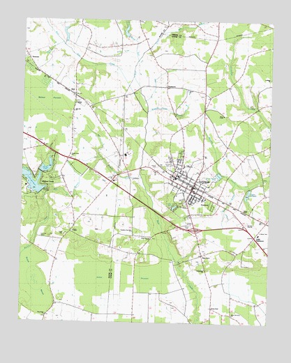
La Grange, NC USGS Topographic Map
Click on map above to begin viewing in our Map Viewer.

This topographic map contains these locations and features:
Feature Name Type Latitude Longitude GNIS ID View Map
Bear Creek W/S Lake Number ThirteenReservoirN35.3692°W77.8232°998878View Map
BestPopulated PlaceN35.3438°W77.8489°981056View Map
Bogue MarshSwampN35.2679°W77.8647°1023843View Map
Buck BranchStreamN35.3085°W77.7669°1024661View Map
EastwoodPopulated PlaceN35.2993°W77.7797°1004590View Map
Fairview CemeteryCemeteryN35.3140°W77.8011°1024611View Map
Frink SchoolSchoolN35.3149°W77.7930°985463View Map
Garris ChapelChurchN35.2877°W77.8489°985584View Map
Holly Hill ChurchChurchN35.3374°W77.8491°1004587View Map
Humphrey Sand Hill ChurchChurchN35.2879°W77.8186°1004591View Map
Jackson ChapelChurchN35.3407°W77.8483°1004588View Map
Jenny LindPopulated PlaceN35.2571°W77.7780°1006254View Map
Jones PocosinSwampN35.2704°W77.8244°987761View Map
La GrangePopulated PlaceN35.3068°W77.7880°988067View Map
La Grange Elementary SchoolSchoolN35.3104°W77.7950°1002664View Map
La Grange Police DepartmentBuildingN35.3068°W77.7878°2130891View Map
La Grange Post OfficePost OfficeN35.3044°W77.7891°2773790View Map
La Grange Town HallBuildingN35.3060°W77.7864°1002665View Map
La Grange Wastewater Treatment PlantLocaleN35.3113°W77.7755°2506007View Map
Lake WackenaReservoirN35.3035°W77.8647°998772View Map
Lake Wackena DamDamN35.3035°W77.8647°1024430View Map
Liberty Grove ChurchChurchN35.2846°W77.8100°988426View Map
Little BaltimorePopulated PlaceN35.2863°W77.7558°1004593View Map
Little Marsh RiverStreamN35.3582°W77.8172°1008249View Map
Mays StoreLocaleN35.2779°W77.7839°989509View Map
Meeting House BranchStreamN35.3374°W77.8122°1004589View Map
Mill BranchStreamN35.3099°W77.8147°1004586View Map
Mill RunStreamN35.3696°W77.8053°989984View Map
Mira BranchStreamN35.3027°W77.8655°1004585View Map
Mosley Hall Fire DepartmentBuildingN35.3070°W77.7869°2639835View Map
Neuse Regional Library - La Grange BranchBuildingN35.3051°W77.7875°2505954View Map
NewsomLocaleN35.3585°W77.8719°1004579View Map
Palmer CemeteryCemeteryN35.3154°W77.8069°991797View Map
Pine LakeLakeN35.2980°W77.7977°1004592View Map
Piney Grove ChurchChurchN35.2527°W77.8616°992345View Map
Rouse ChapelChurchN35.3363°W77.7733°993763View Map
Saint Matthews ChurchChurchN35.2721°W77.7822°994057View Map
ShadetownPopulated PlaceN35.3477°W77.8025°1024665View Map
Simroe ChurchChurchN35.3466°W77.7925°994852View Map
Spring LakeReservoirN35.3118°W77.8664°998785View Map
Spring Lake DamDamN35.3118°W77.8664°998784View Map
Taylors ChapelChurchN35.2971°W77.7628°995898View Map
Town of La GrangeCivilN35.3064°W77.7889°2405964View Map
Township of Moseley HallCivilN35.2922°W77.7819°1026878View Map
Village of Walnut CreekCivilN35.3052°W77.8701°2407566View Map
Walnut CreekPopulated PlaceN35.3071°W77.8650°1003765View Map
Walnut Creek ChurchChurchN35.3191°W77.8505°996738View Map
Walnut Creek ChurchChurchN35.3193°W77.8505°1024610View Map
Walnut Creek Police DepartmentBuildingN35.3006°W77.8663°2769685View Map
Walters MillpondReservoirN35.3036°W77.7606°998774View Map
Walters Millpond DamDamN35.3052°W77.7597°998773View Map
West Bear CreekStreamN35.3521°W77.8197°996985View Map
White Oak Grove ChurchChurchN35.2538°W77.7678°997177View Map
White Oak Grove ChurchChurchN35.2529°W77.7678°1024607View Map
William Creuse DamDamN35.3685°W77.8230°998877View Map

Note: Coordinates in the location and feature list above are referenced to NAD83 datum.


Copyright (C) 2008-2024 Ryan Niemi / Sunset Dynamics ... All Rights Reserved