TopoQuest Logo
Do you find TopoQuest useful?
Help keep TopoQuest running and adding new maps/features by donating!
Bitcoin:  19c7KJd3qBynnjoSw5npx9KScwjBe4ifkT
Litecoin:  LXs6TkuXGGXo1vDsWCkWVdjQX94eUKd6ui
Home View Maps Find Maps Find Places Resources & Links


Kreole, Mississippi Topographic Map

USGS Map Title: Kreole, MS
USGS Map MRC: 30088D4
DRG (GeoTIFF) Download: o30088d4.tif


Neighboring USGS Topographic Map Quads:


  Three Rivers, MS  
30088E5
 

  Big Point, MS  
30088E4
 

  Saint Elmo, AL  
30088E3
 

  Pascagoula North, MS  
30088D5
 

  Kreole, MS  
30088D4
 

  Grand Bay, AL  
30088D3
 

  Pascagoula South, MS  
30088C5
 

  Grand Bay SW, AL  
30088C4
 

  Isle aux Herbes, AL  
30088C3


Map MRC Location:

N31°
W89°
N31°
W88°
H8 H7 H6 H5 H4 H3 H2 H1
G8 G7 G6 G5 G4 G3 G2 G1
F8 F7 F6 F5 F4 F3 F2 F1
E8 E7 E6 E5 E4 E3 E2 E1
D8 D7 D6 D5 D4 D3 D2 D1
C8 C7 C6 C5 C4 C3 C2 C1
B8 B7 B6 B5 B4 B3 B2 B1
A8 A7 A6 A5 A4 A3 A2 A1
N30°
W89°
N30°
W88°

Kreole, MS USGS 1:24K Topographic Map Preview:
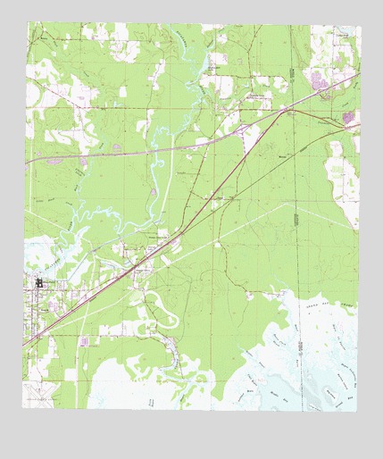
Kreole, MS USGS Topographic Map
Click on map above to begin viewing in our Map Viewer.

This topographic map contains these locations and features:
Feature Name Type Latitude Longitude GNIS ID View Map
Abundance of Blessings Church of God in ChristChurchN30.3999°W88.4963°2596867View Map
Alabama Department of Transportation Interstate 10 Welcome Center Water Treatment LagoonLocaleN30.4783°W88.3869°2579674View Map
Barton IslandIslandN30.3858°W88.3803°113531View Map
Bayou HeronStreamN30.3846°W88.3950°666605View Map
Bayou la FourcheGutN30.3985°W88.3808°113606View Map
Big IslandIslandN30.3813°W88.3850°114291View Map
Black CreekStreamN30.4380°W88.4800°667210View Map
Blessed Hope ChurchChurchN30.4821°W88.3853°1729956View Map
Calling All Christians ChurchChurchN30.3999°W88.4961°688918View Map
Cassels (historical)LocaleN30.4108°W88.4736°710403View Map
Clay BayouStreamN30.3830°W88.4111°668532View Map
Cloverdale Baptist ChurchChurchN30.4817°W88.3866°1729959View Map
Cloverdale Lake DamDamN30.4985°W88.3800°129532View Map
Dees CemeteryCemeteryN30.4996°W88.4217°669209View Map
East Lawn Mobile EstatesPopulated PlaceN30.4108°W88.4771°2596413View Map
East Moss PointPopulated PlaceN30.4135°W88.4917°688959View Map
Eastside Assembly of God ChurchChurchN30.4092°W88.4793°2596895View Map
Evangel Temple Pentecostal Holiness ChurchChurchN30.4016°W88.4947°688961View Map
Ford (historical)LocaleN30.4127°W88.4764°710410View Map
Forts Lake - Franklin Creek Volunteer Fire Department Station 1BuildingN30.4965°W88.4155°2332746View Map
Forts Lake - Franklin Creek Volunteer Fire Department Station 2BuildingN30.4165°W88.4594°2668014View Map
Fourmile CreekGutN30.4671°W88.4931°670134View Map
Franklin CreekStreamN30.4760°W88.4347°118598View Map
Franklin Creek Baptist ChurchChurchN30.4766°W88.4170°670165View Map
Fundarosa Airport (historical)AirportN30.4738°W88.4761°680300View Map
Goodes Mill LakeLakeN30.4885°W88.4327°670493View Map
Grand Bay National Wildlife RefugeParkN30.4153°W88.4170°2675019View Map
Gulf DownsLocaleN30.4910°W88.3820°1729983View Map
HelenaPopulated PlaceN30.4946°W88.4958°671089View Map
Helena ChurchChurchN30.4935°W88.4983°689022View Map
Interchange 75CrossingN30.4663°W88.4192°691361View Map
Interstate 10 Welcome CenterBuildingN30.4626°W88.4343°2596433View Map
Jackson County Airport (historical)AirportN30.3771°W88.4945°680293View Map
Jackson CreekStreamN30.4844°W88.4347°151877View Map
Kivisto CemeteryCemeteryN30.4513°W88.4436°672198View Map
KreolePopulated PlaceN30.4060°W88.4947°672220View Map
Kreole Avenue Baptist ChurchChurchN30.4013°W88.4939°689051View Map
Kreole Christian AcademySchoolN30.4016°W88.4942°689052View Map
Little Black CreekStreamN30.4383°W88.4814°672546View Map
Live Oak AcademySchoolN30.4085°W88.4892°689061View Map
Long IslandIslandN30.3766°W88.3908°122013View Map
Luther Hall LakeReservoirN30.4986°W88.3806°116281View Map
Mattie Clark BayouStreamN30.3938°W88.3992°673245View Map
Middle BayBayN30.3794°W88.4036°673521View Map
Middle BayouStreamN30.3863°W88.4086°673522View Map
Midway United Methodist ChurchChurchN30.4312°W88.4452°2596349View Map
MissalaPopulated PlaceN30.4580°W88.4000°692078View Map
Moss Point Fire Department Kreole StationBuildingN30.4027°W88.4948°2667819View Map
New Vision Church of GodChurchN30.4765°W88.4171°2597129View Map
Orange GrovePopulated PlaceN30.4208°W88.4586°675304View Map
Orange Grove CemeteryCemeteryN30.4147°W88.4601°710417View Map
Orange LakeReservoirN30.4270°W88.4509°675307View Map
Orange Lake Elementary SchoolSchoolN30.4313°W88.4472°711634View Map
PecanPopulated PlaceN30.4435°W88.4292°675557View Map
Pollock Ferry Boat RampLocaleN30.4364°W88.4523°2596871View Map
Reedy BranchStreamN30.4763°W88.3778°125525View Map
Rhema Word International Fellowship ChurchChurchN30.4096°W88.4951°2597130View Map
Southwest BayouStreamN30.3808°W88.4122°678026View Map
Wood School (historical)SchoolN30.4049°W88.4970°689205View Map
Woodland Park Mobile Home VillagePopulated PlaceN30.4187°W88.4595°2596512View Map

Note: Coordinates in the location and feature list above are referenced to NAD83 datum.


Copyright (C) 2008-2024 Ryan Niemi / Sunset Dynamics ... All Rights Reserved