TopoQuest Logo
Do you find TopoQuest useful?
Help keep TopoQuest running and adding new maps/features by donating!
Bitcoin:  19c7KJd3qBynnjoSw5npx9KScwjBe4ifkT
Litecoin:  LXs6TkuXGGXo1vDsWCkWVdjQX94eUKd6ui
Home View Maps Find Maps Find Places Resources & Links


Knob Noster, Missouri Topographic Map

USGS Map Title: Knob Noster, MO
USGS Map MRC: 38093G5
DRG (GeoTIFF) Download: o38093g5.tif


Neighboring USGS Topographic Map Quads:


  Knob Noster NW, MO  
38093H6
 

  Concordia, MO  
38093H5
 

  Sweet Springs, MO  
38093H4
 

  Warrensburg East, MO  
38093G6
 

  Knob Noster, MO  
38093G5
 

  La Monte, MO  
38093G4
 

  Cornelia, MO  
38093F6
 

  Burtville, MO  
38093F5
 

  Green Ridge North, MO  
38093F4


Map MRC Location:

N39°
W94°
N39°
W93°
H8 H7 H6 H5 H4 H3 H2 H1
G8 G7 G6 G5 G4 G3 G2 G1
F8 F7 F6 F5 F4 F3 F2 F1
E8 E7 E6 E5 E4 E3 E2 E1
D8 D7 D6 D5 D4 D3 D2 D1
C8 C7 C6 C5 C4 C3 C2 C1
B8 B7 B6 B5 B4 B3 B2 B1
A8 A7 A6 A5 A4 A3 A2 A1
N38°
W94°
N38°
W93°

Knob Noster, MO USGS 1:24K Topographic Map Preview:
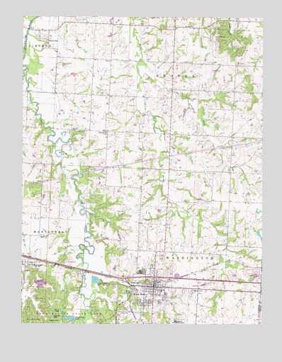
Knob Noster, MO USGS Topographic Map
Click on map above to begin viewing in our Map Viewer.

This topographic map contains these locations and features:
Feature Name Type Latitude Longitude GNIS ID View Map
Boyd PondLakeN38.7628°W93.5685°714596View Map
Brush Hill School (historical)SchoolN38.8738°W93.5131°745518View Map
Brushville School (historical)SchoolN38.7914°W93.5633°745520View Map
Camp ShawneeLocaleN38.7514°W93.6208°715287View Map
Campbell LakeReservoirN38.7567°W93.5719°763389View Map
Campbell Lake DamDamN38.7567°W93.5719°763388View Map
Cana School (historical)SchoolN38.8271°W93.5481°745126View Map
Carbon HillPopulated PlaceN38.7792°W93.6077°755631View Map
City of Knob NosterCivilN38.7675°W93.5616°2395555View Map
Clear Fork Blackwater RiverStreamN38.8489°W93.6235°736161View Map
Clear Fork LakeReservoirN38.7520°W93.5996°758267View Map
Clear Fork Lake DamDamN38.7517°W93.5969°762838View Map
Cooks KnobSummitN38.8672°W93.5252°729723View Map
Dunkard ChurchChurchN38.8200°W93.5488°717187View Map
Foffel LakeReservoirN38.7698°W93.5441°763387View Map
Foffel Lake DamDamN38.7683°W93.5452°763386View Map
Hepsidam School (historical)SchoolN38.8247°W93.5805°745516View Map
Hocker CemeteryCemeteryN38.8566°W93.5418°719656View Map
Immanuel ChurchChurchN38.8281°W93.5813°729755View Map
Jaeger LakeReservoirN38.7866°W93.5019°763079View Map
Jaeger Lake DamDamN38.7883°W93.5019°763078View Map
Johnson County Fire Protection District Station 4BuildingN38.7649°W93.5419°2621718View Map
Knaus CemeteryCemeteryN38.7960°W93.5757°720665View Map
Knob NosterPopulated PlaceN38.7667°W93.5585°729757View Map
Knob Noster Elementary SchoolSchoolN38.7633°W93.5525°745546View Map
Knob Noster High SchoolSchoolN38.7608°W93.5605°2545111View Map
Knob Noster Middle SchoolSchoolN38.7635°W93.5546°2545349View Map
Knob Noster Police DepartmentBuildingN38.7667°W93.5562°2752558View Map
Knob Noster Post OfficePost OfficeN38.7649°W93.5620°2779544View Map
Knob Noster Volunteer Fire DepartmentBuildingN38.7667°W93.5558°2621169View Map
KnobsSummitN38.7767°W93.5522°739166View Map
Lee CemeteryCemeteryN38.7642°W93.6216°729763View Map
Little Walnut CreekStreamN38.8570°W93.5639°721354View Map
Maple Grove School (historical)SchoolN38.8547°W93.5797°745517View Map
Marshall CemeteryCemeteryN38.8749°W93.5593°721903View Map
MontserratPopulated PlaceN38.7747°W93.6219°729779View Map
Morel LakeLakeN38.7551°W93.6045°722602View Map
Oak Grove School (historical)SchoolN38.7964°W93.5185°745521View Map
Pleasant Prairie School (historical)SchoolN38.7559°W93.5019°2744001View Map
Redbud LakeLakeN38.7511°W93.6044°725167View Map
Rothwell CemeteryCemeteryN38.8711°W93.5411°725591View Map
Saint Joseph CemeteryCemeteryN38.7599°W93.5563°725797View Map
Shumate LakeReservoirN38.8017°W93.6135°763391View Map
Shumate Lake DamDamN38.8017°W93.6135°763390View Map
Sullivan LakeLakeN38.7528°W93.6088°727271View Map
Township of GroverCivilN38.8722°W93.5522°766832View Map
Valley CityPopulated PlaceN38.8656°W93.6119°729828View Map
Wampler CemeteryCemeteryN38.8286°W93.5983°728334View Map
Woodland School (historical)SchoolN38.8378°W93.5174°745519View Map

Note: Coordinates in the location and feature list above are referenced to NAD83 datum.


Copyright (C) 2008-2024 Ryan Niemi / Sunset Dynamics ... All Rights Reserved