TopoQuest Logo
Do you find TopoQuest useful?
Help keep TopoQuest running and adding new maps/features by donating!
Bitcoin:  19c7KJd3qBynnjoSw5npx9KScwjBe4ifkT
Litecoin:  LXs6TkuXGGXo1vDsWCkWVdjQX94eUKd6ui
Home View Maps Find Maps Find Places Resources & Links


Knappa, Oregon Topographic Map

USGS Map Title: Knappa, OR
USGS Map MRC: 46123B5
DRG (GeoTIFF) Download: o46123b5.tif


Neighboring USGS Topographic Map Quads:


  Rosburg, WA  
46123C6
 

  Grays River, WA  
46123C5
 

  Skamokawa, WA  
46123C4
 

  Cathlamet Bay, OR  
46123B6
 

  Knappa, OR  
46123B5
 

  Cathlamet, WA  
46123B4
 

  Green Mountain, OR  
46123A6
 

  Wickiup Mountain, OR  
46123A5
 

  Nicolai Mountain, OR  
46123A4


Map MRC Location:

N47°
W124°
N47°
W123°
H8 H7 H6 H5 H4 H3 H2 H1
G8 G7 G6 G5 G4 G3 G2 G1
F8 F7 F6 F5 F4 F3 F2 F1
E8 E7 E6 E5 E4 E3 E2 E1
D8 D7 D6 D5 D4 D3 D2 D1
C8 C7 C6 C5 C4 C3 C2 C1
B8 B7 B6 B5 B4 B3 B2 B1
A8 A7 A6 A5 A4 A3 A2 A1
N46°
W124°
N46°
W123°

Knappa, OR USGS 1:24K Topographic Map Preview:
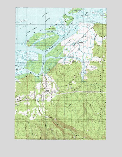
Knappa, OR USGS Topographic Map
Click on map above to begin viewing in our Map Viewer.

This topographic map contains these locations and features:
Feature Name Type Latitude Longitude GNIS ID View Map
Albert Post Office (historical)Post OfficeN46.2336°W123.5178°1164174View Map
Aldrich Point (historical)LocaleN46.2340°W123.5176°1167942View Map
Aldrich Point Boat RampLocaleN46.2349°W123.5196°2058185View Map
Barrow CreekStreamN46.1568°W123.6235°1132298View Map
Big CreekStreamN46.1846°W123.5929°1117602View Map
Big Creek County ParkParkN46.1651°W123.5921°2058186View Map
Big Noise CreekStreamN46.1771°W123.5221°1117647View Map
Blind SloughStreamN46.2012°W123.5824°1117816View Map
Blind Slough (historical)Populated PlaceN46.2018°W123.5624°1167943View Map
Blind Slough Post Office (historical)Post OfficeN46.2047°W123.5544°1164223View Map
BrownsmeadPopulated PlaceN46.2176°W123.5407°1637833View Map
Brownsmead Post Office (historical)Post OfficeN46.2176°W123.5407°1164973View Map
Brush IslandIslandN46.2307°W123.5754°1118156View Map
Carmen CreekStreamN46.1540°W123.5971°1132295View Map
Devils ElbowBendN46.2343°W123.5468°1119900View Map
Dogwood CreekStreamN46.1707°W123.5679°1132296View Map
Fertile Valley CreekStreamN46.1851°W123.5812°1120695View Map
Gnat CreekStreamN46.1993°W123.5340°1121175View Map
Gnat Creek CampgroundParkN46.1768°W123.5049°2058157View Map
Goose IslandIslandN46.2448°W123.5315°1121243View Map
Grizzly SloughStreamN46.2037°W123.5654°1121451View Map
Horseshoe IslandIslandN46.2337°W123.5593°1122026View Map
Jim Crow SandsBarN46.2493°W123.5793°1122428View Map
Karlson IslandIslandN46.1998°W123.6012°1122637View Map
KnappaPopulated PlaceN46.1851°W123.5860°1136447View Map
Knappa - Svensen - Burnside Fire District Brownsmead Station 22BBuildingN46.2101°W123.5399°2577038View Map
Knappa DocksLocaleN46.1875°W123.5889°2668279View Map
Knappa Guard StationLocaleN46.1457°W123.6071°1122808View Map
Knappa High SchoolSchoolN46.1625°W123.6222°1151651View Map
Knappa JunctionLocaleN46.1696°W123.5840°1122809View Map
Knappa Post Office (historical)Post OfficeN46.1851°W123.5860°1165495View Map
Knappa SloughStreamN46.1893°W123.6068°1122810View Map
Knappa Svensen Rural Fire Protection DepartmentBuildingN46.1675°W123.5837°2577028View Map
Knappa Water AssociationLocaleN46.1700°W123.5813°2660783View Map
Lewis And Clark National Wildlife RefugeParkN46.2153°W123.6206°1133436View Map
Little CreekStreamN46.1843°W123.5946°1123170View Map
Long IslandIslandN46.2146°W123.5590°1123431View Map
Maplewood CemeteryCemeteryN46.1773°W123.5532°1135166View Map
Marsh IslandIslandN46.2187°W123.5868°1123785View Map
Marsh Island CreekGutN46.2262°W123.5696°1158347View Map
Marsh Island LightIslandN46.2143°W123.6182°1123786View Map
Mill CreekStreamN46.1471°W123.5957°1132299View Map
Minaker IslandIslandN46.1909°W123.6226°1158376View Map
Prairie CemeteryCemeteryN46.1740°W123.5837°1135167View Map
Quinns IslandIslandN46.2440°W123.5012°1125757View Map
Rock CreekStreamN46.1782°W123.5285°1126152View Map
Snag Island JettyDamN46.2315°W123.6201°1127142View Map
Snag IslandsIslandN46.2362°W123.6129°1127143View Map
Supply CreekStreamN46.1807°W123.5335°1127766View Map
Tillusqua Fish HatcheryLocaleN46.1462°W123.5810°1163780View Map
Tronson IslandIslandN46.2409°W123.5271°1128235View Map
Warren SloughStreamN46.1884°W123.5865°1128674View Map
Wickiup Water DistrictLocaleN46.1400°W123.6069°2660747View Map
Woody IslandIslandN46.2479°W123.5426°1129320View Map

Note: Coordinates in the location and feature list above are referenced to NAD83 datum.


Copyright (C) 2008-2024 Ryan Niemi / Sunset Dynamics ... All Rights Reserved