TopoQuest Logo
Do you find TopoQuest useful?
Help keep TopoQuest running and adding new maps/features by donating!
Bitcoin:  19c7KJd3qBynnjoSw5npx9KScwjBe4ifkT
Litecoin:  LXs6TkuXGGXo1vDsWCkWVdjQX94eUKd6ui
Home View Maps Find Maps Find Places Resources & Links


Kitchings Mill, South Carolina Topographic Map

USGS Map Title: Kitchings Mill, SC
USGS Map MRC: 33081E4
DRG (GeoTIFF) Download: o33081e4.tif


Neighboring USGS Topographic Map Quads:


  Foxtown, SC  
33081F5
 

  Seivern, SC  
33081F4
 

  Wagener, SC  
33081F3
 

  Oakwood, SC  
33081E5
 

  Kitchings Mill, SC  
33081E4
 

  Salley, SC  
33081E3
 

  Windsor, SC  
33081D5
 

  Williston, SC  
33081D4
 

  Springfield, SC  
33081D3


Map MRC Location:

N34°
W82°
N34°
W81°
H8 H7 H6 H5 H4 H3 H2 H1
G8 G7 G6 G5 G4 G3 G2 G1
F8 F7 F6 F5 F4 F3 F2 F1
E8 E7 E6 E5 E4 E3 E2 E1
D8 D7 D6 D5 D4 D3 D2 D1
C8 C7 C6 C5 C4 C3 C2 C1
B8 B7 B6 B5 B4 B3 B2 B1
A8 A7 A6 A5 A4 A3 A2 A1
N33°
W82°
N33°
W81°

Kitchings Mill, SC USGS 1:24K Topographic Map Preview:
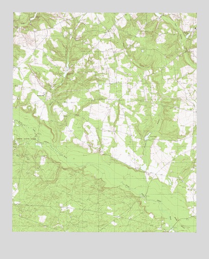
Kitchings Mill, SC USGS Topographic Map
Click on map above to begin viewing in our Map Viewer.

This topographic map contains these locations and features:
Feature Name Type Latitude Longitude GNIS ID View Map
Aiken State ParkParkN33.5507°W81.4904°1220143View Map
Aiken State Park LakeReservoirN33.5497°W81.4819°1237968View Map
Baughmans PondReservoirN33.5897°W81.4644°1237974View Map
Brodies PondReservoirN33.6120°W81.3811°1220983View Map
Burcalo CreekStreamN33.5457°W81.4698°1221127View Map
Burcalo School (historical)SchoolN33.5940°W81.4973°1236260View Map
Chapman Branch ChurchChurchN33.5793°W81.4215°1221510View Map
Davis BridgeBridgeN33.5026°W81.3909°1247498View Map
Friendship ChurchChurchN33.5838°W81.3795°1236338View Map
Friendship SchoolSchoolN33.5832°W81.3793°1222583View Map
Garvins PondReservoirN33.6216°W81.4862°1237964View Map
Goodyear PondReservoirN33.5366°W81.4111°1237962View Map
Gum Ridge SchoolSchoolN33.6132°W81.4190°1222947View Map
Hunter BranchStreamN33.5226°W81.4140°1223397View Map
Johnsons PondReservoirN33.6038°W81.3823°1246189View Map
Keadle BridgeBridgeN33.5207°W81.4101°1246221View Map
Kitchings MillPopulated PlaceN33.5785°W81.4773°1246262View Map
Kitchins Mill School (historical)SchoolN33.5735°W81.4632°1236402View Map
Okanola SchoolSchoolN33.5940°W81.4873°1225165View Map
Pine Log BridgeBridgeN33.5554°W81.4832°1225465View Map
Piney Grove School (historical)SchoolN33.5732°W81.4304°1250135View Map
Pond BranchStreamN33.5040°W81.3929°1225597View Map
Sandy IslandIslandN33.5057°W81.3862°1226366View Map
Smyrna ChurchChurchN33.5435°W81.4126°1226713View Map
South Carolina Noname 02013 D-1997 DamDamN33.5532°W81.4090°1237959View Map
South Carolina Noname 02014 D-2030 DamDamN33.5385°W81.4115°1237961View Map
South Carolina Noname 02015 D-1998 DamDamN33.6201°W81.4887°1237963View Map
South Carolina Noname 02017 D-1999 DamDamN33.5501°W81.4815°1237967View Map
South Carolina Noname 02020 D-2001 DamDamN33.5888°W81.4645°1237973View Map
Tabernacle ChurchChurchN33.5468°W81.4395°1227012View Map
Trinity Poultry FarmLocaleN33.5733°W81.3847°2635235View Map
Tyler CemeteryCemeteryN33.6032°W81.3790°1236569View Map
Tylers PondReservoirN33.5544°W81.4084°1227274View Map
Wexford LandingAirportN33.5939°W81.4979°2650818View Map
Williams PondReservoirN33.6250°W81.4021°1238086View Map
Zion Hill Baptist ChurchChurchN33.5946°W81.4598°1251560View Map

Note: Coordinates in the location and feature list above are referenced to NAD83 datum.


Copyright (C) 2008-2024 Ryan Niemi / Sunset Dynamics ... All Rights Reserved