TopoQuest Logo
Do you find TopoQuest useful?
Help keep TopoQuest running and adding new maps/features by donating!
Bitcoin:  19c7KJd3qBynnjoSw5npx9KScwjBe4ifkT
Litecoin:  LXs6TkuXGGXo1vDsWCkWVdjQX94eUKd6ui
Home View Maps Find Maps Find Places Resources & Links


Kingswood, Kentucky Topographic Map

USGS Map Title: Kingswood, KY
USGS Map MRC: 37086F4
DRG (GeoTIFF) Download: o37086f4.tif


Neighboring USGS Topographic Map Quads:


  Mattingly, KY  
37086G5
 

  Hardinsburg, KY  
37086G4
 

  Garfield, KY  
37086G3
 

  Glen Dean, KY  
37086F5
 

  Kingswood, KY  
37086F4
 

  Custer, KY  
37086F3
 

  Falls of Rough, KY  
37086E5
 

  McDaniels, KY  
37086E4
 

  Madrid, KY  
37086E3


Map MRC Location:

N38°
W87°
N38°
W86°
H8 H7 H6 H5 H4 H3 H2 H1
G8 G7 G6 G5 G4 G3 G2 G1
F8 F7 F6 F5 F4 F3 F2 F1
E8 E7 E6 E5 E4 E3 E2 E1
D8 D7 D6 D5 D4 D3 D2 D1
C8 C7 C6 C5 C4 C3 C2 C1
B8 B7 B6 B5 B4 B3 B2 B1
A8 A7 A6 A5 A4 A3 A2 A1
N37°
W87°
N37°
W86°

Kingswood, KY USGS 1:24K Topographic Map Preview:
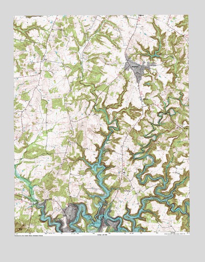
Kingswood, KY USGS Topographic Map
Click on map above to begin viewing in our Map Viewer.

This topographic map contains these locations and features:
Feature Name Type Latitude Longitude GNIS ID View Map
AxtelPopulated PlaceN37.6442°W86.4758°507431View Map
Buffalo CreekStreamN37.7003°W86.3819°488313View Map
Calamese CreekStreamN37.6426°W86.3914°488587View Map
Cave SpringPopulated PlaceN37.6495°W86.4241°507668View Map
Cave Spring ChurchChurchN37.6567°W86.4200°489138View Map
KingswoodPopulated PlaceN37.7189°W86.4086°495771View Map
KirkPopulated PlaceN37.7239°W86.4786°508393View Map
Mount Zion ChurchChurchN37.7136°W86.4122°498939View Map
Picnic Area Site 5LocaleN37.6312°W86.4361°500563View Map
RoffPopulated PlaceN37.6603°W86.4230°502271View Map
Saint Anthonys SchoolSchoolN37.6342°W86.4622°502578View Map
Sand KnobSummitN37.6270°W86.4972°502922View Map
Sand Knob ChurchChurchN37.6426°W86.4883°502923View Map
Se ReePopulated PlaceN37.6834°W86.3797°503129View Map
Tuckers BranchStreamN37.6467°W86.3880°505548View Map
Tules CreekStreamN37.6317°W86.4408°505560View Map
WestviewPopulated PlaceN37.7001°W86.4091°506504View Map
White Oak CreekStreamN37.6526°W86.3922°506620View Map

Note: Coordinates in the location and feature list above are referenced to NAD83 datum.


Copyright (C) 2008-2024 Ryan Niemi / Sunset Dynamics ... All Rights Reserved