TopoQuest Logo
Do you find TopoQuest useful?
Help keep TopoQuest running and adding new maps/features by donating!
Bitcoin:  19c7KJd3qBynnjoSw5npx9KScwjBe4ifkT
Litecoin:  LXs6TkuXGGXo1vDsWCkWVdjQX94eUKd6ui
Home View Maps Find Maps Find Places Resources & Links


Kidder, Missouri Topographic Map

USGS Map Title: Kidder, MO
USGS Map MRC: 39094G1
DRG (GeoTIFF) Download: o39094g1.tif


Neighboring USGS Topographic Map Quads:


  Weatherby, MO  
39094H2
 

  Altamont, MO  
39094H1
 

  Gallatin, MO  
39093H8
 

  Winston, MO  
39094G2
 

  Kidder, MO  
39094G1
 

  Nettleton, MO  
39093G8
 

  Cameron East, MO  
39094F2
 

  Hamilton West, MO  
39094F1
 

  Hamilton East, MO  
39093F8


Map MRC Location:

N40°
W95°
N40°
W94°
H8 H7 H6 H5 H4 H3 H2 H1
G8 G7 G6 G5 G4 G3 G2 G1
F8 F7 F6 F5 F4 F3 F2 F1
E8 E7 E6 E5 E4 E3 E2 E1
D8 D7 D6 D5 D4 D3 D2 D1
C8 C7 C6 C5 C4 C3 C2 C1
B8 B7 B6 B5 B4 B3 B2 B1
A8 A7 A6 A5 A4 A3 A2 A1
N39°
W95°
N39°
W94°

Kidder, MO USGS 1:24K Topographic Map Preview:
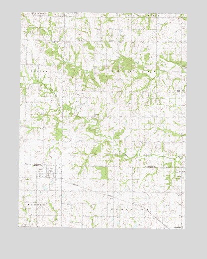
Kidder, MO USGS Topographic Map
Click on map above to begin viewing in our Map Viewer.

This topographic map contains these locations and features:
Feature Name Type Latitude Longitude GNIS ID View Map
Advance SchoolSchoolN39.7722°W94.0116°713164View Map
Allen School (historical)SchoolN39.8011°W94.0788°713224View Map
Bowman CemeteryCemeteryN39.7786°W94.0038°742042View Map
Castor School (historical)SchoolN39.8444°W94.1113°715484View Map
City of KidderCivilN39.7822°W94.1023°2395526View Map
Hopkins School (historical)SchoolN39.8600°W94.0663°719823View Map
KidderPopulated PlaceN39.7803°W94.1024°730125View Map
Kidder - Altamont - Winston Volunteer Fire Protection District KidderBuildingN39.7817°W94.1009°2621029View Map
Kidder Post OfficePost OfficeN39.7818°W94.1048°2782665View Map
Lone Star School (historical)SchoolN39.8083°W94.1072°721475View Map
Lovely Ridge School (historical)SchoolN39.7597°W94.0591°721622View Map
Madison SchoolSchoolN39.8589°W94.0124°721747View Map
Number 534 DamDamN39.7750°W94.1002°764523View Map
Selle SchoolSchoolN39.8003°W94.0130°730209View Map
Swisher SchoolSchoolN39.8297°W94.0119°727396View Map
Township of SheridanCivilN39.8290°W94.0388°766588View Map
Wesley ChapelChurchN39.8300°W94.0041°742044View Map
Wooderson CemeteryCemeteryN39.8150°W94.0691°742043View Map
Wooderson School (historical)SchoolN39.8219°W94.0652°729095View Map

Note: Coordinates in the location and feature list above are referenced to NAD83 datum.


Copyright (C) 2008-2024 Ryan Niemi / Sunset Dynamics ... All Rights Reserved