TopoQuest Logo
Do you find TopoQuest useful?
Help keep TopoQuest running and adding new maps/features by donating!
Bitcoin:  19c7KJd3qBynnjoSw5npx9KScwjBe4ifkT
Litecoin:  LXs6TkuXGGXo1vDsWCkWVdjQX94eUKd6ui
Home View Maps Find Maps Find Places Resources & Links


Kenbridge West, Virginia Topographic Map

USGS Map Title: Kenbridge West, VA
USGS Map MRC: 36078H2
DRG (GeoTIFF) Download: o36078h2.tif


Neighboring USGS Topographic Map Quads:


  Meherrin, VA  
37078A3
 

  Rubermont, VA  
37078A2
 

  Blackstone West, VA  
37078A1
 

  Lunenburg, VA  
36078H3
 

  Kenbridge West, VA  
36078H2
 

  Kenbridge East, VA  
36078H1
 

  Wightman, VA  
36078G3
 

  North View, VA  
36078G2
 

  Forksville, VA  
36078G1


Map MRC Location:

N37°
W79°
N37°
W78°
H8 H7 H6 H5 H4 H3 H2 H1
G8 G7 G6 G5 G4 G3 G2 G1
F8 F7 F6 F5 F4 F3 F2 F1
E8 E7 E6 E5 E4 E3 E2 E1
D8 D7 D6 D5 D4 D3 D2 D1
C8 C7 C6 C5 C4 C3 C2 C1
B8 B7 B6 B5 B4 B3 B2 B1
A8 A7 A6 A5 A4 A3 A2 A1
N36°
W79°
N36°
W78°

Kenbridge West, VA USGS 1:24K Topographic Map Preview:
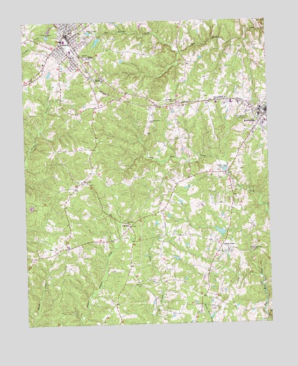
Kenbridge West, VA USGS Topographic Map
Click on map above to begin viewing in our Map Viewer.

This topographic map contains these locations and features:
Feature Name Type Latitude Longitude GNIS ID View Map
Beech ForestWoodsN36.9543°W78.1953°1492132View Map
Browns Store DistrictCivilN36.9409°W78.1494°1927118View Map
Central High SchoolSchoolN36.9851°W78.2161°1464690View Map
Church of ChristChurchN36.9985°W78.2258°1690156View Map
Church of the NazareneChurchN36.9938°W78.2258°1690157View Map
First Baptist ChurchChurchN36.9829°W78.2244°1493949View Map
Gilfield Reformed Zion Union Apostolic ChurchChurchN36.9833°W78.2222°2745667View Map
Gilfield Zion United Methodist ChurchChurchN36.9832°W78.2222°1690158View Map
Good Hope ChurchChurchN36.9168°W78.1978°1467206View Map
KenbridgePopulated PlaceN36.9621°W78.1250°1495781View Map
Kenbridge DamDamN36.9385°W78.1464°1490361View Map
Kenbridge Heights CemeteryCemeteryN36.9610°W78.1375°1468945View Map
Kenbridge Volunteer Fire DepartmentBuildingN36.9612°W78.1251°2086150View Map
Lakeview CemeteryCemeteryN36.9926°W78.2156°1469101View Map
Lunenburg BeachBeachN36.9927°W78.2097°1492175View Map
Lunenburg Beach DamDamN36.9935°W78.2102°1490356View Map
Lunenburg Beach ReservoirReservoirN36.9919°W78.2114°1490357View Map
Lunenburg CountyCivilN36.9462°W78.2406°1492239View Map
Lunenburg County AirportAirportN36.9602°W78.1841°1498705View Map
Lunenburg High SchoolSchoolN36.9774°W78.2094°1469936View Map
Lunenburg Middle SchoolSchoolN36.9887°W78.2067°2499260View Map
Marshall DamDamN36.9785°W78.2364°1490362View Map
Mayflower ChurchChurchN36.9054°W78.1325°1470212View Map
Mount Bethel ChurchChurchN36.9668°W78.1725°1470811View Map
Non Intervention (historical)Populated PlaceN36.9057°W78.1328°1492191View Map
Oakwood CemeteryCemeteryN36.9854°W78.2189°1471795View Map
Oral OaksPopulated PlaceN36.9151°W78.1958°1477594View Map
Sneads CornerPopulated PlaceN36.9074°W78.1494°1496238View Map
Sneads DamDamN36.9135°W78.1464°1490350View Map
Sneads PondReservoirN36.9135°W78.1464°1490351View Map
Town of KenbridgeCivilN36.9609°W78.1284°2391251View Map
Town of VictoriaCivilN36.9947°W78.2242°2391459View Map
Unity ChurchChurchN36.8910°W78.1908°1476102View Map
Unity School (historical)SchoolN36.9021°W78.1539°1492228View Map
VictoriaPopulated PlaceN36.9949°W78.2272°1496356View Map
Victoria Baptist ChurchChurchN36.9952°W78.2261°1690159View Map
Victoria Elementary SchoolSchoolN36.9958°W78.2248°2499237View Map
Victoria Fire and RescueBuildingN36.9904°W78.2245°2086149View Map
Victoria Fire DepartmentBuildingN36.9907°W78.2245°2331684View Map
Victoria High School (historical)SchoolN36.9957°W78.2250°1690160View Map
Victoria Methodist ChurchChurchN36.9968°W78.2250°1690161View Map
Victoria Police DepartmentBuildingN36.9948°W78.2271°2086154View Map
Victoria Post OfficePost OfficeN36.9937°W78.2267°1492230View Map
Victoria Presbyterian ChurchChurchN36.9952°W78.2264°1690162View Map
West Hill ChurchChurchN36.9340°W78.2197°1476491View Map

Note: Coordinates in the location and feature list above are referenced to NAD83 datum.


Copyright (C) 2008-2024 Ryan Niemi / Sunset Dynamics ... All Rights Reserved