TopoQuest Logo
Do you find TopoQuest useful?
Help keep TopoQuest running and adding new maps/features by donating!
Bitcoin:  19c7KJd3qBynnjoSw5npx9KScwjBe4ifkT
Litecoin:  LXs6TkuXGGXo1vDsWCkWVdjQX94eUKd6ui
Home View Maps Find Maps Find Places Resources & Links


Bangor, Kentucky Topographic Map

USGS Map Title: Bangor, KY
USGS Map MRC: 38083A4
DRG (GeoTIFF) Download: o38083a4.tif


Neighboring USGS Topographic Map Quads:


  Farmers, KY  
38083B5
 

  Morehead, KY  
38083B4
 

  Haldeman, KY  
38083B3
 

  Salt Lick, KY  
38083A5
 

  Bangor, KY  
38083A4
 

  Wrigley, KY  
38083A3
 

  Scranton, KY  
37083H5
 

  Ezel, KY  
37083H4
 

  West Liberty, KY  
37083H3


Map MRC Location:

N39°
W84°
N39°
W83°
H8 H7 H6 H5 H4 H3 H2 H1
G8 G7 G6 G5 G4 G3 G2 G1
F8 F7 F6 F5 F4 F3 F2 F1
E8 E7 E6 E5 E4 E3 E2 E1
D8 D7 D6 D5 D4 D3 D2 D1
C8 C7 C6 C5 C4 C3 C2 C1
B8 B7 B6 B5 B4 B3 B2 B1
A8 A7 A6 A5 A4 A3 A2 A1
N38°
W84°
N38°
W83°

Bangor, KY USGS 1:24K Topographic Map Preview:
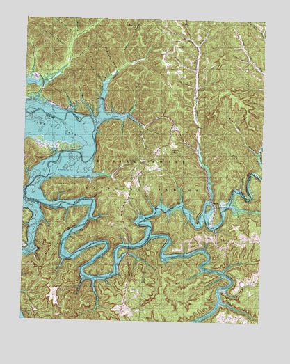
Bangor, KY USGS Topographic Map
Click on map above to begin viewing in our Map Viewer.

This topographic map contains these locations and features:
Feature Name Type Latitude Longitude GNIS ID View Map
Abbott CemeteryCemeteryN38.0509°W83.4294°2079424View Map
Alfrey Boat RampLocaleN38.0915°W83.4982°516674View Map
Alfrey ChurchChurchN38.0919°W83.4912°2127139View Map
Back-Peyton CemeteryCemeteryN38.0721°W83.4310°2079434View Map
Baldridge CemeteryCemeteryN38.0232°W83.4243°2079436View Map
BangorPopulated PlaceN38.0434°W83.4388°510183View Map
Bangor Boat RampLocaleN38.0331°W83.4396°516683View Map
Bangor Post Office (historical)Post OfficeN38.0359°W83.4320°2362601View Map
Barber BranchStreamN38.0545°W83.3868°510388View Map
Barn HollowValleyN38.0258°W83.4395°516980View Map
Bear BranchStreamN38.0198°W83.3941°510456View Map
Beaver CreekStreamN38.0498°W83.4980°510489View Map
Bertis Post Office (historical)Post OfficeN38.0255°W83.4625°2400748View Map
Biddle HollowValleyN38.1216°W83.4672°510592View Map
Big HollowValleyN38.0979°W83.4590°516837View Map
Big HollowValleyN38.0984°W83.4594°516979View Map
Boyd BranchStreamN38.1115°W83.4091°516678View Map
Brown Cemetery FourCemeteryN38.0609°W83.4425°2079652View Map
Brush HollowValleyN38.1142°W83.4097°510970View Map
Brushy BranchStreamN38.1076°W83.4760°510971View Map
Brushy ForkStreamN38.1040°W83.4105°516677View Map
Buck CreekStreamN38.0476°W83.4969°511002View Map
Carpenter BranchStreamN38.0426°W83.4919°511221View Map
Carpenter BranchStreamN38.0470°W83.4313°511222View Map
Cassidy Ford HollowValleyN38.0877°W83.4757°511240View Map
Cave BranchStreamN38.0237°W83.4505°511266View Map
Cave Branch School (historical)SchoolN38.0300°W83.4497°2416632View Map
Cave Run LakeReservoirN38.0625°W83.4818°511277View Map
Charity BranchStreamN38.0429°W83.4649°511317View Map
Charity Freewill Baptist ChurchChurchN38.0780°W83.4093°2099716View Map
Claylick Boat RampLocaleN38.0587°W83.4646°516686View Map
Claylick Boat-in CampgroundLocaleN38.0590°W83.4721°516685View Map
Claylick BranchStreamN38.0654°W83.4674°511389View Map
Claylick BranchStreamN38.0987°W83.4980°511390View Map
CogswellPopulated PlaceN38.1025°W83.4983°511452View Map
Cornett CemeteryCemeteryN38.0389°W83.4448°2079720View Map
Coswell School (historical)SchoolN38.0920°W83.4916°2127141View Map
Don McKinsey BranchStreamN38.1029°W83.4527°511862View Map
Donahue School (historical)SchoolN38.0302°W83.4550°2416634View Map
Dry BranchStreamN38.0976°W83.4110°511911View Map
Ellington CemeteryCemeteryN38.0440°W83.4094°2079743View Map
Ellington South CemeteryCemeteryN38.0693°W83.4262°2079745View Map
Elm Log BranchStreamN38.0204°W83.3946°512056View Map
Forman CemeteryCemeteryN38.0879°W83.4122°2079756View Map
Fuget BranchStreamN38.0254°W83.4769°512259View Map
Giant Canada Goose PondLakeN38.1006°W83.4946°516671View Map
Ginter CemeteryCemeteryN38.0304°W83.4985°512320View Map
Gregory Cemetery OneCemeteryN38.1091°W83.3751°2079777View Map
Ham BranchStreamN38.0498°W83.4630°512532View Map
Harlan Ellington CemeteryCemeteryN38.0444°W83.4105°2079746View Map
Hickory GroveLocaleN38.0079°W83.3852°2362564View Map
Hickory Grove (historical)Populated PlaceN38.0352°W83.4078°2362578View Map
Hill BranchStreamN38.1140°W83.4102°512705View Map
Horsely-Brown CemeteryCemeteryN38.0446°W83.4073°2079814View Map
J Foster CemeteryCemeteryN38.1080°W83.3838°2079757View Map
Jones Cemetery OneCemeteryN38.0843°W83.4097°2079840View Map
Lakeview VistaLocaleN38.0876°W83.4807°516836View Map
Laurel BranchStreamN38.0084°W83.3960°513232View Map
Lick ForkPopulated PlaceN38.0965°W83.4110°513400View Map
Lick Fork Railroad Station (historical)LocaleN38.0960°W83.4104°2127143View Map
Licking River SchoolSchoolN38.0270°W83.4038°513417View Map
Licking Union Railroad Station (historical)LocaleN38.0716°W83.4909°2416429View Map
Limekiln HollowValleyN38.1087°W83.3834°513426View Map
Link CemeteryCemeteryN38.1176°W83.4219°2079860View Map
Little Laurel BranchStreamN38.0145°W83.3924°513494View Map
Lockegee BranchStreamN38.1059°W83.4474°513558View Map
Lockegee RockSummitN38.1229°W83.4477°513559View Map
Long BranchStreamN38.0492°W83.4814°513600View Map
Long BranchStreamN38.0463°W83.4768°513601View Map
Lower Lick ForkStreamN38.0440°W83.4049°513411View Map
Lower Lick Fork ChurchChurchN38.0929°W83.4102°516680View Map
McClure CemeteryCemeteryN38.0707°W83.4100°2079905View Map
Mckinney CemeteryCemeteryN38.1180°W83.4133°2079916View Map
McKinsey School (historical)SchoolN38.0780°W83.4617°2127142View Map
Middle ForkStreamN38.0801°W83.4380°516679View Map
Mine BranchStreamN38.0220°W83.4049°514022View Map
Mount Hope (historical)Populated PlaceN38.0507°W83.4448°2127160View Map
Mount Hope CemeteryCemeteryN38.0496°W83.4452°2080058View Map
Mount Hope SchoolSchoolN38.0495°W83.4452°514092View Map
Mount Hope School (historical)SchoolN38.0494°W83.4456°2127159View Map
Muskie Bend Fishing PointLocaleN38.0915°W83.4924°516673View Map
North Fork Licking RiverStreamN38.0343°W83.4341°514292View Map
Old House HollowValleyN38.0829°W83.4487°514327View Map
Orchard BranchStreamN38.1123°W83.4774°514369View Map
ParagonPopulated PlaceN38.0481°W83.3993°514431View Map
Paragon Railroad Station (historical)LocaleN38.0475°W83.3998°2127156View Map
Paragon School (historical)SchoolN38.0486°W83.3906°2362708View Map
Paragon School (historical)SchoolN38.0481°W83.3998°2127155View Map
Peter Everett BranchStreamN38.1156°W83.4760°514511View Map
Peyton-Igo CemeteryCemeteryN38.0406°W83.4520°2079941View Map
Pickett BranchStreamN38.0481°W83.4182°514536View Map
Poppin HillSummitN38.0444°W83.3980°2127158View Map
Poppin Rock Boat RampLocaleN38.0412°W83.4018°516684View Map
Poppin Rock TunnelTunnelN38.0481°W83.3980°514722View Map
Popping Post Office (historical)Post OfficeN38.0490°W83.3911°2362662View Map
Pound BranchStreamN38.0173°W83.4563°514736View Map
Ramey CemeteryCemeteryN38.0647°W83.4300°2079955View Map
Ramey CreekStreamN38.0864°W83.4599°514835View Map
Ramey Creek Picnic AreaLocaleN38.0962°W83.4577°516676View Map
Roll Alfrey CemeteryCemeteryN38.0516°W83.4554°2079430View Map
Salt Spring BranchStreamN38.0170°W83.4621°515196View Map
Scale Ladder HollowValleyN38.0275°W83.4933°515277View Map
Shallow Flats Fishing PointLocaleN38.1015°W83.4938°516675View Map
Shrout HollowValleyN38.0844°W83.4644°515396View Map
Stacy-Peyton CemeteryCemeteryN38.0480°W83.4356°2079987View Map
Stillhouse BranchStreamN38.1176°W83.4735°515710View Map
Sugar Camp BranchStreamN38.0809°W83.4385°515784View Map
Sugar Cane BranchStreamN38.0851°W83.4463°515788View Map
Tackett CemeteryCemeteryN38.0667°W83.4377°2079995View Map
Thomas Cave BranchStreamN38.0967°W83.4102°515927View Map
Three Forks BranchStreamN38.0809°W83.4385°515937View Map
Twolick BranchStreamN38.0171°W83.4672°516085View Map
Upper Lick Fork SchoolSchoolN38.1045°W83.3771°516138View Map
Utterback CemeteryCemeteryN38.1036°W83.4850°2080016View Map
Wallace Cemetery OneCemeteryN38.0805°W83.4226°2080025View Map
Wallace Cemetery ThreeCemeteryN38.0743°W83.4257°2080029View Map
Warix RunStreamN38.0845°W83.4562°516230View Map
Warix Run Boat RampLocaleN38.0842°W83.4441°516681View Map
Wellford Post Office (historical)Post OfficeN38.0090°W83.3888°2362672View Map
White Pine BranchStreamN38.0698°W83.3766°516328View Map
Wilson HillSummitN38.0556°W83.4830°516404View Map
Windy Bay Fishing PointLocaleN38.0865°W83.4571°516682View Map
Yale Post Office (historical)Post OfficeN38.0490°W83.4972°2416652View Map
Yocum CreekStreamN38.0484°W83.3913°516511View Map
Zilpo Post Office (historical)Post OfficeN38.0719°W83.4909°2416532View Map
Zilpo Recreation AreaPopulated PlaceN38.0745°W83.4932°516529View Map

Note: Coordinates in the location and feature list above are referenced to NAD83 datum.


Copyright (C) 2008-2024 Ryan Niemi / Sunset Dynamics ... All Rights Reserved