TopoQuest Logo
Do you find TopoQuest useful?
Help keep TopoQuest running and adding new maps/features by donating!
Bitcoin:  19c7KJd3qBynnjoSw5npx9KScwjBe4ifkT
Litecoin:  LXs6TkuXGGXo1vDsWCkWVdjQX94eUKd6ui
Home View Maps Find Maps Find Places Resources & Links


Junction City, Ohio Topographic Map

USGS Map Title: Junction City, OH
USGS Map MRC: 39082F3
DRG (GeoTIFF) Download: o39082f3.tif


Neighboring USGS Topographic Map Quads:


  Rushville, OH  
39082G4
 

  Somerset, OH  
39082G3
 

  Fultonham, OH  
39082G2
 

  Bremen, OH  
39082F4
 

  Junction City, OH  
39082F3
 

  New Lexington, OH  
39082F2
 

  Logan, OH  
39082E4
 

  Gore, OH  
39082E3
 

  New Straitsville, OH  
39082E2


Map MRC Location:

N40°
W83°
N40°
W82°
H8 H7 H6 H5 H4 H3 H2 H1
G8 G7 G6 G5 G4 G3 G2 G1
F8 F7 F6 F5 F4 F3 F2 F1
E8 E7 E6 E5 E4 E3 E2 E1
D8 D7 D6 D5 D4 D3 D2 D1
C8 C7 C6 C5 C4 C3 C2 C1
B8 B7 B6 B5 B4 B3 B2 B1
A8 A7 A6 A5 A4 A3 A2 A1
N39°
W83°
N39°
W82°

Junction City, OH USGS 1:24K Topographic Map Preview:
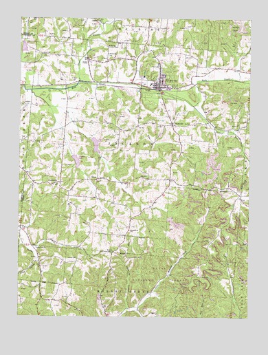
Junction City, OH USGS Topographic Map
Click on map above to begin viewing in our Map Viewer.

This topographic map contains these locations and features:
Feature Name Type Latitude Longitude GNIS ID View Map
Asbury (historical)Populated PlaceN39.6826°W82.2929°1067167View Map
Asbury Post Office (historical)Post OfficeN39.6820°W82.2929°2042144View Map
Bethel CemeteryCemeteryN39.6523°W82.3238°1963611View Map
Bethel ChurchChurchN39.6523°W82.3235°1075362View Map
Brehm RunStreamN39.7476°W82.3302°2045805View Map
CarthonPopulated PlaceN39.7490°W82.3318°1075534View Map
Carthon Post Office (historical)Post OfficeN39.7487°W82.3318°2042149View Map
Center Branch Rush CreekStreamN39.7223°W82.3435°1077341View Map
Clark RunStreamN39.7198°W82.3693°2045795View Map
ClarksvillePopulated PlaceN39.7053°W82.2913°1075580View Map
Coalbrook CreekStreamN39.6270°W82.3157°1067169View Map
Coalbrook HollowValleyN39.6290°W82.3149°1075599View Map
Coon HollowValleyN39.6484°W82.3652°1075622View Map
CrossenvillePopulated PlaceN39.6806°W82.3563°1075655View Map
Crossenville Post Office (historical)Post OfficeN39.6806°W82.3596°2042156View Map
Dry RunStreamN39.7231°W82.3363°1075744View Map
Fairview CemeteryCemeteryN39.6498°W82.3429°1075823View Map
Fairview United Brethren Church (historical)ChurchN39.6495°W82.3432°1065665View Map
Five PointsLocaleN39.6765°W82.2543°1050180View Map
Flagdale LakeLakeN39.6901°W82.3439°1083560View Map
Friendship ChurchChurchN39.6615°W82.3143°1075886View Map
Friendship Methodist Episcopal CemeteryCemeteryN39.6609°W82.3146°1963623View Map
Harvey CemeteryCemeteryN39.7350°W82.3630°1076020View Map
Harvey Chapel (historical)ChurchN39.7348°W82.3624°1065670View Map
Junction CityPopulated PlaceN39.7212°W82.2988°1064918View Map
Junction City Elementary SchoolSchoolN39.7226°W82.3040°1050181View Map
Junction City ParkParkN39.7226°W82.3071°1083562View Map
Junction City Post OfficePost OfficeN39.7209°W82.2985°2042296View Map
Junction City Volunteer Fire DepartmentBuildingN39.7207°W82.3007°2550417View Map
Lideys RunStreamN39.7303°W82.3432°2045782View Map
Mount Zion United Brethren In Christ CemeteryCemeteryN39.7379°W82.3228°1963638View Map
Mount Zion United Brethren in Christ ChurchChurchN39.7381°W82.3229°1076470View Map
New Lebanon Evangelical Lutheran CemeteryCemeteryN39.7309°W82.2999°1963639View Map
New Lebanon Evangelical Lutheran ChurchChurchN39.7312°W82.2999°1963640View Map
Ohio State Penitentiary Junction City BranchLocaleN39.7317°W82.3360°1080158View Map
Old Zion United Brethren CemeteryCemeteryN39.7348°W82.3271°1963649View Map
Old Zion United Brethren ChurchChurchN39.7353°W82.3263°1076566View Map
Pigeonroost School (historical)SchoolN39.6709°W82.2585°1065680View Map
Pine View Tree FarmLocaleN39.6636°W82.3431°2647902View Map
Rush Creek Conservation District Structure 5a DamDamN39.7359°W82.3723°1078880View Map
Rush Creek Conservation District Structure ReservoirReservoirN39.7378°W82.3728°1078881View Map
Rush Creek School (historical)SchoolN39.7292°W82.2663°1065681View Map
Saint Johns CemeteryCemeteryN39.6423°W82.2760°1076796View Map
Saint Patricks CemeteryCemeteryN39.7073°W82.2918°1963659View Map
Saint Patricks ChurchChurchN39.7065°W82.2918°1963660View Map
SalemPopulated PlaceN39.6826°W82.3354°1076806View Map
Salem RunStreamN39.7128°W82.3590°2045781View Map
Township of JacksonCivilN39.6953°W82.3116°1086783View Map
Turkey RunStreamN39.7137°W82.2804°1077086View Map
Turkey Run Mennonite ChurchChurchN39.6545°W82.3654°1077083View Map
Twin Churches LakeLakeN39.6969°W82.3335°1083561View Map
Village of Junction CityCivilN39.7217°W82.2998°2398315View Map

Note: Coordinates in the location and feature list above are referenced to NAD83 datum.


Copyright (C) 2008-2024 Ryan Niemi / Sunset Dynamics ... All Rights Reserved