TopoQuest Logo
Do you find TopoQuest useful?
Help keep TopoQuest running and adding new maps/features by donating!
Bitcoin:  19c7KJd3qBynnjoSw5npx9KScwjBe4ifkT
Litecoin:  LXs6TkuXGGXo1vDsWCkWVdjQX94eUKd6ui
Home View Maps Find Maps Find Places Resources & Links


Julian, Nebraska Topographic Map

USGS Map Title: Julian, NE
USGS Map MRC: 40095E7
DRG (GeoTIFF) Download: o40095e7.tif


Neighboring USGS Topographic Map Quads:


  Nebraska City NW, NE  
40095F8
 

  Nebraska City, NE  
40095F7
 

  Sidney, IA  
40095F6
 

  Paul, NE  
40095E8
 

  Julian, NE  
40095E7
 

  Hamburg, IA  
40095E6
 

  Brock, NE  
40095D8
 

  Auburn, NE  
40095D7
 

  Peru, NE  
40095D6


Map MRC Location:

N41°
W96°
N41°
W95°
H8 H7 H6 H5 H4 H3 H2 H1
G8 G7 G6 G5 G4 G3 G2 G1
F8 F7 F6 F5 F4 F3 F2 F1
E8 E7 E6 E5 E4 E3 E2 E1
D8 D7 D6 D5 D4 D3 D2 D1
C8 C7 C6 C5 C4 C3 C2 C1
B8 B7 B6 B5 B4 B3 B2 B1
A8 A7 A6 A5 A4 A3 A2 A1
N40°
W96°
N40°
W95°

Julian, NE USGS 1:24K Topographic Map Preview:
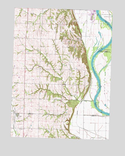
Julian, NE USGS Topographic Map
Click on map above to begin viewing in our Map Viewer.

This topographic map contains these locations and features:
Feature Name Type Latitude Longitude GNIS ID View Map
ArborLocaleN40.5964°W95.7892°1884189View Map
Barney (historical)LocaleN40.5378°W95.7842°1884226View Map
Buffalo City DamDamN40.5690°W95.8406°1770038View Map
Buffalo City ReservoirReservoirN40.5691°W95.8415°1770039View Map
Camp CreekStreamN40.5375°W95.7711°827889View Map
Camp Creek CemeteryCemeteryN40.5681°W95.8022°827893View Map
Camp Creek ChapelChurchN40.5681°W95.8022°2677861View Map
Camp Creek Post Office (historical)Post OfficeN40.5525°W95.8119°1884221View Map
Camp Creek School (historical)SchoolN40.5522°W95.8117°827895View Map
Duck CreekStreamN40.5006°W95.7531°828868View Map
Gress Farms Airport (historical)AirportN40.5917°W95.8733°837646View Map
Harmony SchoolSchoolN40.5522°W95.8719°829813View Map
Hazel Dell Public SchoolSchoolN40.5881°W95.8406°829899View Map
JulianPopulated PlaceN40.5228°W95.8678°830423View Map
JulianLocaleN40.5217°W95.8697°1883870View Map
Julian Ag Service ElevatorLocaleN40.5228°W95.8678°1883867View Map
Julian Post OfficePost OfficeN40.5228°W95.8678°1883869View Map
Julian Volunteer Fire DepartmentBuildingN40.5217°W95.8689°2553439View Map
MinersvillePopulated PlaceN40.5969°W95.7892°835382View Map
Minersville (historical)LocaleN40.5969°W95.7892°1884222View Map
Minersville Post Office (historical)Post OfficeN40.5969°W95.7892°1884223View Map
Nebraska City Municipal AirportAirportN40.6048°W95.8624°1884237View Map
North Branch Camp CreekStreamN40.5611°W95.8147°831659View Map
Northwest Missouri Planning DistrictCivilN40.5592°W95.7503°754100View Map
Olson (historical)LocaleN40.5639°W95.7753°1884225View Map
Otoe City Post Office (historical)Post OfficeN40.5972°W95.7892°1884224View Map
Otoe Election PrecinctCivilN40.5669°W95.8288°1929126View Map
Platte PurchaseAreaN40.5500°W95.7506°754111View Map
Pleasant Grove School (historical)SchoolN40.5961°W95.8150°832165View Map
Saint Bernards ChurchChurchN40.5075°W95.8594°832846View Map
Schemmel IslandIslandN40.6211°W95.7592°461462View Map
South Branch Camp CreekStreamN40.5369°W95.7922°833546View Map
Steamboat Trace TrailTrailN40.5750°W95.7808°1884232View Map
United Methodist ChurchChurchN40.5228°W95.8678°1883868View Map
Village of JulianCivilN40.5199°W95.8674°2398313View Map

Note: Coordinates in the location and feature list above are referenced to NAD83 datum.


Copyright (C) 2008-2024 Ryan Niemi / Sunset Dynamics ... All Rights Reserved