TopoQuest Logo
Do you find TopoQuest useful?
Help keep TopoQuest running and adding new maps/features by donating!
Bitcoin:  19c7KJd3qBynnjoSw5npx9KScwjBe4ifkT
Litecoin:  LXs6TkuXGGXo1vDsWCkWVdjQX94eUKd6ui
Home View Maps Find Maps Find Places Resources & Links


Clarence Cannon Dam, Missouri Topographic Map

USGS Map Title: Clarence Cannon Dam, MO
USGS Map MRC: 39091E6
DRG (GeoTIFF) Download: o39091e6.tif


Neighboring USGS Topographic Map Quads:


  Hunnewell, MO  
39091F7
 

  Monroe City, MO  
39091F6
 

  Rensselaer, MO  
39091F5
 

  Stoutsville, MO  
39091E7
 

  Clarence Cannon Dam, MO  
39091E6
 

  Center, MO  
39091E5
 

  Florida, MO  
39091D7
 

  Perry, MO  
39091D6
 

  Perry NE, MO  
39091D5


Map MRC Location:

N40°
W92°
N40°
W91°
H8 H7 H6 H5 H4 H3 H2 H1
G8 G7 G6 G5 G4 G3 G2 G1
F8 F7 F6 F5 F4 F3 F2 F1
E8 E7 E6 E5 E4 E3 E2 E1
D8 D7 D6 D5 D4 D3 D2 D1
C8 C7 C6 C5 C4 C3 C2 C1
B8 B7 B6 B5 B4 B3 B2 B1
A8 A7 A6 A5 A4 A3 A2 A1
N39°
W92°
N39°
W91°

Clarence Cannon Dam, MO USGS 1:24K Topographic Map Preview:
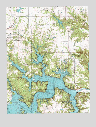
Clarence Cannon Dam, MO USGS Topographic Map
Click on map above to begin viewing in our Map Viewer.

This topographic map contains these locations and features:
Feature Name Type Latitude Longitude GNIS ID View Map
Bethlehem ChurchChurchN39.6070°W91.6735°729280View Map
Black HawkLocaleN39.5159°W91.7238°759448View Map
Blackjack MarinaLocaleN39.5112°W91.6524°759443View Map
Cedar RidgeRidgeN39.5234°W91.6582°759439View Map
Clarence Cannon DamDamN39.5281°W91.6399°766172View Map
Clear ViewLocaleN39.5348°W91.6515°759437View Map
County Line FordLocaleN39.5017°W91.7132°716384View Map
Deer RunLocaleN39.5087°W91.6649°759442View Map
DeMoss ChurchChurchN39.6045°W91.6874°729300View Map
Dry ForkStreamN39.5020°W91.6485°717111View Map
Eagle PointLocaleN39.5237°W91.7107°759445View Map
Ely BranchStreamN39.5028°W91.7071°717563View Map
Flint RidgeLocaleN39.5309°W91.6518°759438View Map
FoxLocaleN39.5189°W91.7115°759446View Map
Frank Russell Recreation AreaParkN39.5356°W91.6477°736212View Map
Gentry School (historical)SchoolN39.6231°W91.6593°718390View Map
Henderson LakeReservoirN39.5277°W91.7175°719375View Map
Hereford School (historical)SchoolN39.6203°W91.6965°719396View Map
Hickory Bluff TrailTrailN39.5231°W91.6654°759440View Map
Indian CreekStreamN39.5400°W91.6790°720123View Map
Indian Creek MarinaLocaleN39.5212°W91.7254°759450View Map
Indian Creek Recreation AreaParkN39.5392°W91.7332°736216View Map
JoannaPopulated PlaceN39.5409°W91.6693°740967View Map
John F Spalding Recreation AreaParkN39.5542°W91.6590°736213View Map
Lick Creek TrailTrailN39.5056°W91.6582°759444View Map
Little BluestemLocaleN39.5150°W91.6613°759441View Map
Little Indian CreekStreamN39.5398°W91.6938°721257View Map
M W Boudreaux Recreation AreaParkN39.5153°W91.6335°736211View Map
Madden BranchStreamN39.5745°W91.7040°721738View Map
Madden School (historical)SchoolN39.5823°W91.6896°721740View Map
Mark Twain Lake Management OfficeBuildingN39.5362°W91.6449°759436View Map
Monroe City DamDamN39.6067°W91.6618°761075View Map
Monroe City LakeReservoirN39.6067°W91.6618°761076View Map
Monroe City South Lake DamDamN39.6217°W91.7335°761069View Map
Monroe Lake BReservoirN39.6218°W91.7298°761070View Map
Mount Hope ChurchChurchN39.5137°W91.6757°729347View Map
Mount Pleasant School (historical)SchoolN39.5456°W91.6882°722873View Map
Mudd School (historical)SchoolN39.5289°W91.7260°729352View Map
Night HawkLocaleN39.5187°W91.7202°759447View Map
Nolen School (historical)SchoolN39.6134°W91.7354°723411View Map
Norton School (historical)SchoolN39.5131°W91.6757°743913View Map
Oakland ChurchChurchN39.5500°W91.6674°729361View Map
Pleasant Grove ChurchChurchN39.5062°W91.6288°729369View Map
Ray Behrens Recreation AreaParkN39.5159°W91.6632°736214View Map
Rocklick School (historical)SchoolN39.5778°W91.6488°729380View Map
Sandy CreekStreamN39.5084°W91.7210°726042View Map
Sentry RidgeLocaleN39.5189°W91.7227°759449View Map
Shaver FordPopulated PlaceN39.5217°W91.6896°755572View Map
Shepard FordLocaleN39.5337°W91.6257°755630View Map
Spillway Recreation AreaParkN39.5231°W91.6277°736210View Map
The LandingPopulated PlaceN39.5637°W91.6610°736249View Map
Thompson Lake DamDamN39.6217°W91.6452°765252View Map
Township of SalineCivilN39.6107°W91.6446°767252View Map
Utterback CemeteryCemeteryN39.5081°W91.6918°728092View Map
Yager School (historical)SchoolN39.5428°W91.6429°729182View Map

Note: Coordinates in the location and feature list above are referenced to NAD83 datum.


Copyright (C) 2008-2024 Ryan Niemi / Sunset Dynamics ... All Rights Reserved