TopoQuest Logo
Do you find TopoQuest useful?
Help keep TopoQuest running and adding new maps/features by donating!
Bitcoin:  19c7KJd3qBynnjoSw5npx9KScwjBe4ifkT
Litecoin:  LXs6TkuXGGXo1vDsWCkWVdjQX94eUKd6ui
Home View Maps Find Maps Find Places Resources & Links


Jenkins, Minnesota Topographic Map

USGS Map Title: Jenkins, MN
USGS Map MRC: 46094F3
DRG (GeoTIFF) Download: o46094f3.tif


Neighboring USGS Topographic Map Quads:


  Mildred, MN  
46094G4
 

  Lake Ada, MN  
46094G3
 

  Stewart Lake, MN  
46094G2
 

  Pine River, MN  
46094F4
 

  Jenkins, MN  
46094F3
 

  Lower Whitefish Lake, MN  
46094F2
 

  Pine River SW, MN  
46094E4
 

  Nisswa, MN  
46094E3
 

  Pelican Lake, MN  
46094E2


Map MRC Location:

N47°
W95°
N47°
W94°
H8 H7 H6 H5 H4 H3 H2 H1
G8 G7 G6 G5 G4 G3 G2 G1
F8 F7 F6 F5 F4 F3 F2 F1
E8 E7 E6 E5 E4 E3 E2 E1
D8 D7 D6 D5 D4 D3 D2 D1
C8 C7 C6 C5 C4 C3 C2 C1
B8 B7 B6 B5 B4 B3 B2 B1
A8 A7 A6 A5 A4 A3 A2 A1
N46°
W95°
N46°
W94°

Jenkins, MN USGS 1:24K Topographic Map Preview:
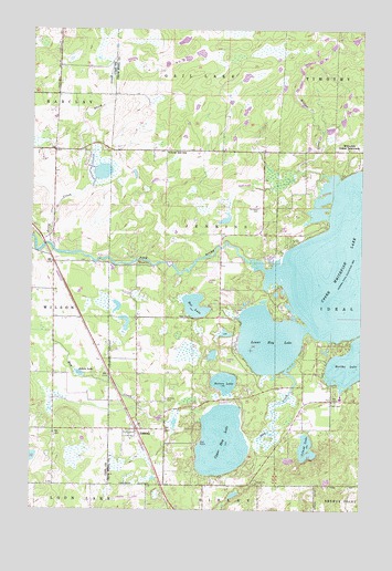
Jenkins, MN USGS Topographic Map
Click on map above to begin viewing in our Map Viewer.

This topographic map contains these locations and features:
Feature Name Type Latitude Longitude GNIS ID View Map
Arvig CreekStreamN46.6936°W94.3675°639461View Map
Bertha LakeLakeN46.6637°W94.2535°639981View Map
City of JenkinsCivilN46.6526°W94.3298°2395464View Map
Clover Hill SchoolSchoolN46.7183°W94.3244°641353View Map
Driftwood Gift Shop and MuseumBuildingN46.6783°W94.2806°2094124View Map
Driftwood Resort Golf CourseLocaleN46.6783°W94.2806°2094125View Map
Hay CreekStreamN46.6619°W94.2780°644766View Map
Irish Hills Golf CourseLocaleN46.6981°W94.2806°2094129View Map
Island LakeLakeN46.6411°W94.2705°645481View Map
JenkinsPopulated PlaceN46.6461°W94.3347°645619View Map
Jenkins (historical)LocaleN46.6472°W94.3361°2071756View Map
Jenkins CemeteryCemeteryN46.6541°W94.3239°645620View Map
Jenkins Church of GodChurchN46.6475°W94.3333°2071758View Map
Jenkins Post OfficePost OfficeN46.6461°W94.3344°2071757View Map
Jokela LakeLakeN46.6604°W94.3569°645724View Map
Lower Hay LakeLakeN46.6691°W94.2848°647252View Map
Myers FieldAirportN46.6275°W94.3394°660348View Map
Nelson LakeLakeN46.6582°W94.3017°648460View Map
Norwood CemeteryCemeteryN46.7036°W94.2894°648765View Map
Rat LakeLakeN46.6781°W94.3131°649841View Map
River View RV ParkLocaleN46.6944°W94.3667°2071110View Map
Township of JenkinsCivilN46.6816°W94.3090°664580View Map
Ultraflyte Incorporated AirportAirportN46.6650°W94.3433°660235View Map
Upper Hay LakeLakeN46.6428°W94.3026°653549View Map
Upper Whitefish LakeLakeN46.6928°W94.2539°653574View Map
Whitefish Gospel TabernacleChurchN46.7188°W94.2553°654100View Map
Willow CreekStreamN46.7111°W94.2630°654182View Map

Note: Coordinates in the location and feature list above are referenced to NAD83 datum.


Copyright (C) 2008-2024 Ryan Niemi / Sunset Dynamics ... All Rights Reserved