TopoQuest Logo
Do you find TopoQuest useful?
Help keep TopoQuest running and adding new maps/features by donating!
Bitcoin:  19c7KJd3qBynnjoSw5npx9KScwjBe4ifkT
Litecoin:  LXs6TkuXGGXo1vDsWCkWVdjQX94eUKd6ui
Home View Maps Find Maps Find Places Resources & Links


Jena East, Louisiana Topographic Map

USGS Map Title: Jena East, LA
USGS Map MRC: 31092F1
DRG (GeoTIFF) Download: o31092f1.tif


Neighboring USGS Topographic Map Quads:


  Summerville, LA  
31092G2
 

  Nickel, LA  
31092G1
 

  Aimwell, LA  
31091G8
 

  Jena West, LA  
31092F2
 

  Jena East, LA  
31092F1
 

  Manifest, LA  
31091F8
 

  Nebo, LA  
31092E2
 

  Bird Island Point, LA  
31092E1
 

  Walters, LA  
31091E8


Map MRC Location:

N32°
W93°
N32°
W92°
H8 H7 H6 H5 H4 H3 H2 H1
G8 G7 G6 G5 G4 G3 G2 G1
F8 F7 F6 F5 F4 F3 F2 F1
E8 E7 E6 E5 E4 E3 E2 E1
D8 D7 D6 D5 D4 D3 D2 D1
C8 C7 C6 C5 C4 C3 C2 C1
B8 B7 B6 B5 B4 B3 B2 B1
A8 A7 A6 A5 A4 A3 A2 A1
N31°
W93°
N31°
W92°

Jena East, LA USGS 1:24K Topographic Map Preview:
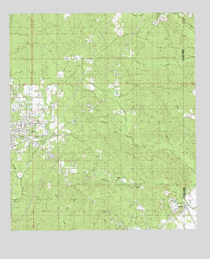
Jena East, LA USGS Topographic Map
Click on map above to begin viewing in our Map Viewer.

This topographic map contains these locations and features:
Feature Name Type Latitude Longitude GNIS ID View Map
Bellevue Baptist ChurchChurchN31.6732°W92.1246°553591View Map
BladePopulated PlaceN31.6543°W92.0529°553706View Map
Blade ChurchChurchN31.6632°W92.0654°533204View Map
CanePopulated PlaceN31.6441°W92.0196°545907View Map
Center School (historical)SchoolN31.6657°W92.0540°545909View Map
Dempsey CemeteryCemeteryN31.7066°W92.1123°534500View Map
Ezell BranchStreamN31.6377°W92.1249°534874View Map
Hair CemeteryCemeteryN31.6918°W92.0971°1952125View Map
Hair CreekStreamN31.6543°W92.1179°554642View Map
Jackson CemeteryCemeteryN31.6924°W92.0973°535986View Map
Jena CemeteryCemeteryN31.6679°W92.0965°536018View Map
Jena Elementary SchoolSchoolN31.6822°W92.1205°545928View Map
Jena Junior High SchoolSchoolN31.6954°W92.1234°545930View Map
Jena Seminary (historical)SchoolN31.6732°W92.1243°545931View Map
Jena Town ParkParkN31.6857°W92.1229°545932View Map
KJNA-AM (Jena)TowerN31.6771°W92.1174°1632529View Map
KJNA-FM (Jena)TowerN31.6977°W92.0954°1632452View Map
Moseley CemeteryCemeteryN31.6268°W92.0376°1952111View Map
Mount Vernon Baptist ChurchChurchN31.6827°W92.0065°546039View Map
Nolley CemeteryCemeteryN31.6813°W92.1246°545952View Map
Nolley Memorial United Methodist ChurchChurchN31.6821°W92.1249°545953View Map
Oak Grove Baptist ChurchChurchN31.6824°W92.0065°546043View Map
Oak Grove CemeteryCemeteryN31.6818°W92.0068°537773View Map
Oak Grove School (historical)SchoolN31.6824°W92.0065°546044View Map
Oak Ridge Baptist ChurchChurchN31.6566°W92.0899°555529View Map
Palmetto CreekStreamN31.6813°W92.0474°555588View Map
Parish Governing Authority District 4CivilN31.7385°W92.0778°1930019View Map
Parish Governing Authority District 5CivilN31.6981°W92.1229°1930084View Map
Penecost CemeteryCemeteryN31.6716°W92.1126°1952109View Map
Pine Grove Baptist ChurchChurchN31.6399°W92.0407°555655View Map
Pine Grove School (historical)SchoolN31.6399°W92.0404°545958View Map
Pleasant Hill Baptist ChurchChurchN31.7174°W92.0551°555683View Map
Pleasant Hill CemeteryCemeteryN31.7174°W92.0548°545960View Map
Pleasant Hill School (historical)SchoolN31.7168°W92.0554°545961View Map
Pritchard CemeteryCemeteryN31.6413°W92.0451°555728View Map
RhinehartPopulated PlaceN31.6377°W92.0068°555794View Map
Rhinehart Post OfficePost OfficeN31.6257°W92.0335°1630387View Map
RoutonPopulated PlaceN31.7021°W92.0526°1630389View Map
Sandy HollowValleyN31.6322°W92.0902°539165View Map
Tar Kiln BranchStreamN31.6702°W92.0165°539790View Map
Ward FiveCivilN31.6882°W92.1165°545107View Map
Ward FourCivilN31.6960°W92.0985°545106View Map
White Hall Volunteer Fire DepartmentBuildingN31.6265°W92.0461°2672818View Map

Note: Coordinates in the location and feature list above are referenced to NAD83 datum.


Copyright (C) 2008-2024 Ryan Niemi / Sunset Dynamics ... All Rights Reserved