TopoQuest Logo
Do you find TopoQuest useful?
Help keep TopoQuest running and adding new maps/features by donating!
Bitcoin:  19c7KJd3qBynnjoSw5npx9KScwjBe4ifkT
Litecoin:  LXs6TkuXGGXo1vDsWCkWVdjQX94eUKd6ui
Home View Maps Find Maps Find Places Resources & Links


Jacksonboro Bridge, Georgia Topographic Map

USGS Map Title: Jacksonboro Bridge, GA
USGS Map MRC: 32081G5
DRG (GeoTIFF) Download: o32081g5.tif


Neighboring USGS Topographic Map Quads:


  Hilltonia, GA  
32081H6
 

  Burtons Ferry Landing, GA  
32081H5
 

  Bull Pond, SC  
32081H4
 

  Sylvania North, GA  
32081G6
 

  Jacksonboro Bridge, GA  
32081G5
 

  Brier Creek Landing, GA  
32081G4
 

  Sylvania South, GA  
32081F6
 

  Hunters, GA  
32081F5
 

  Blue Springs Landing, GA  
32081F4


Map MRC Location:

N33°
W82°
N33°
W81°
H8 H7 H6 H5 H4 H3 H2 H1
G8 G7 G6 G5 G4 G3 G2 G1
F8 F7 F6 F5 F4 F3 F2 F1
E8 E7 E6 E5 E4 E3 E2 E1
D8 D7 D6 D5 D4 D3 D2 D1
C8 C7 C6 C5 C4 C3 C2 C1
B8 B7 B6 B5 B4 B3 B2 B1
A8 A7 A6 A5 A4 A3 A2 A1
N32°
W82°
N32°
W81°

Jacksonboro Bridge, GA USGS 1:24K Topographic Map Preview:
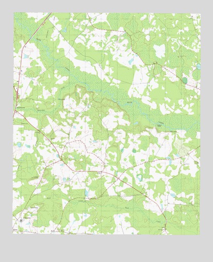
Jacksonboro Bridge, GA USGS Topographic Map
Click on map above to begin viewing in our Map Viewer.

This topographic map contains these locations and features:
Feature Name Type Latitude Longitude GNIS ID View Map
Beaverdam CreekStreamN32.8560°W81.6023°310999View Map
Beaverdam CreekStreamN32.8363°W81.5804°354514View Map
Blue SpringsSpringN32.8266°W81.5943°311560View Map
Boddiford PondReservoirN32.7726°W81.5177°341486View Map
Boddiford Pond DamDamN32.7718°W81.5165°341485View Map
Bryans Bridge (historical)BridgeN32.8488°W81.5954°334888View Map
Buck Creek CemeteryCemeteryN32.7535°W81.5240°350159View Map
Buck Creek ChurchChurchN32.7529°W81.5237°354897View Map
Camp Grove ChurchChurchN32.7521°W81.5926°312229View Map
Community Christian SchoolSchoolN32.7546°W81.6219°2453103View Map
Dixon PondReservoirN32.8502°W81.6165°341484View Map
Dixon Pond DamDamN32.8502°W81.6165°341483View Map
Elmwood School (historical)SchoolN32.7757°W81.5623°334891View Map
Friendship ChurchChurchN32.8035°W81.6001°355935View Map
Friendship Memorial CemeteryCemeteryN32.7821°W81.6065°314435View Map
Goodwill ChurchChurchN32.7671°W81.5043°314694View Map
Horseshoe Lead CreekStreamN32.8163°W81.5309°1227778View Map
Indian BranchStreamN32.8191°W81.6071°315887View Map
Jacksonboro (historical)Populated PlaceN32.8224°W81.6229°350176View Map
Jacksonboro BridgeBridgeN32.8210°W81.6232°316024View Map
Jacksonboro MonumentParkN32.8293°W81.6229°350177View Map
Jacobsons LandingLocaleN32.8124°W81.5282°332084View Map
Kittles LandingLocaleN32.8088°W81.5198°332156View Map
Lariscy LakeReservoirN32.7733°W81.5757°340341View Map
Lariscy Lake DamDamN32.7735°W81.5765°340340View Map
Lawton Grove ChurchChurchN32.8071°W81.6062°316703View Map
McBride United Methodist ChurchChurchN32.7849°W81.5659°2502272View Map
McBridge ChurchChurchN32.7849°W81.5654°317843View Map
New Bridge (historical)BridgeN32.8316°W81.5662°334905View Map
Oak Grove CemeteryCemeteryN32.8507°W81.5137°350184View Map
Oak Grove ChurchChurchN32.8510°W81.5132°319797View Map
Reddick CemeteryCemeteryN32.8118°W81.6171°321415View Map
Reddick CemeteryCemeteryN32.8118°W81.6176°321416View Map
ResourcePopulated PlaceN32.7514°W81.5833°2677693View Map
Saint Peter African Methodist Episcopal ChurchChurchN32.8033°W81.6006°2502169View Map
Saint Stephens ChurchChurchN32.7899°W81.5104°322313View Map
Screven CountyCivilN32.7506°W81.6119°350204View Map
Screven County Middle SchoolSchoolN32.7578°W81.6192°2453127View Map
South Prong Buck CreekStreamN32.7568°W81.5248°323271View Map
Sylvania Water Pollution Control PlantLocaleN32.7646°W81.6144°2502448View Map
Wesley Anna ChurchChurchN32.7702°W81.5721°325001View Map

Note: Coordinates in the location and feature list above are referenced to NAD83 datum.


Copyright (C) 2008-2024 Ryan Niemi / Sunset Dynamics ... All Rights Reserved