TopoQuest Logo
Do you find TopoQuest useful?
Help keep TopoQuest running and adding new maps/features by donating!
Bitcoin:  19c7KJd3qBynnjoSw5npx9KScwjBe4ifkT
Litecoin:  LXs6TkuXGGXo1vDsWCkWVdjQX94eUKd6ui
Home View Maps Find Maps Find Places Resources & Links


Jack Creek Ranch, Colorado Topographic Map

USGS Map Title: Jack Creek Ranch, CO
USGS Map MRC: 40106D1
DRG (GeoTIFF) Download: o40106d1.tif


Neighboring USGS Topographic Map Quads:


  Owl Ridge, CO  
40106E2
 

  Gould, CO  
40106E1
 

  Clark Peak, CO  
40105E8
 

  Rand, CO  
40106D2
 

  Jack Creek Ranch, CO  
40106D1
 

  Mount Richthofen, CO  
40105D8
 

  Parkview Mountain, CO  
40106C2
 

  Radial Mountain, CO  
40106C1
 

  Bowen Mountain, CO  
40105C8


Map MRC Location:

N41°
W107°
N41°
W106°
H8 H7 H6 H5 H4 H3 H2 H1
G8 G7 G6 G5 G4 G3 G2 G1
F8 F7 F6 F5 F4 F3 F2 F1
E8 E7 E6 E5 E4 E3 E2 E1
D8 D7 D6 D5 D4 D3 D2 D1
C8 C7 C6 C5 C4 C3 C2 C1
B8 B7 B6 B5 B4 B3 B2 B1
A8 A7 A6 A5 A4 A3 A2 A1
N40°
W107°
N40°
W106°

Jack Creek Ranch, CO USGS 1:24K Topographic Map Preview:
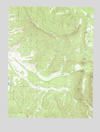
Jack Creek Ranch, CO USGS Topographic Map
Click on map above to begin viewing in our Map Viewer.

This topographic map contains these locations and features:
Feature Name Type Latitude Longitude GNIS ID View Map
Brocker PlaceLocaleN40.4705°W106.1247°202122View Map
Calamity PassGapN40.4416°W106.0111°172920View Map
Cattail Number 1 DamDamN40.3816°W106.1189°198472View Map
Cattail Pond DamDamN40.3766°W106.1139°199512View Map
Cattail ReservoirReservoirN40.3766°W106.1139°199513View Map
Cattail Reservoir Number 1ReservoirN40.3816°W106.1189°198473View Map
Donath LakeReservoirN40.4650°W106.0539°200841View Map
Donath Lake DamDamN40.4650°W106.0539°200840View Map
Elk CreekStreamN40.4214°W106.0636°172918View Map
Fairport DamDamN40.4850°W106.0689°200306View Map
Fairport ReservoirReservoirN40.4850°W106.0689°200307View Map
Flying Dutchman DitchCanalN40.4222°W106.1034°172914View Map
Garland DitchCanalN40.4500°W106.1142°202121View Map
Haney DrawValleyN40.4204°W106.1074°172910View Map
Horse CreekStreamN40.3947°W106.0139°172905View Map
Horse ParkFlatN40.4178°W106.0114°172906View Map
Horseshoe Number 2 DamDamN40.4416°W106.0472°200308View Map
Jack Creek RanchLocaleN40.4241°W106.0467°172916View Map
Jay DitchCanalN40.4361°W106.1095°202119View Map
La Fevre CreekStreamN40.4994°W106.0189°172687View Map
La Fevre RidgeRidgeN40.4080°W106.0214°172904View Map
Lake LovelandReservoirN40.4050°W106.0872°200315View Map
Lake Loveland DamDamN40.4050°W106.0872°200314View Map
Lake RoslynReservoirN40.4150°W106.1239°199981View Map
Lake Roslyn DamDamN40.4150°W106.1239°199980View Map
Lake RubyReservoirN40.4129°W106.1247°202117View Map
Lily LakeLakeN40.4531°W106.0143°172922View Map
Oldenburg DitchCanalN40.4250°W106.0881°172915View Map
Olive DitchCanalN40.4089°W106.0736°172913View Map
Owl MountainSummitN40.4683°W106.0417°202097View Map
Owl Mountain LookoutLocaleN40.4700°W106.0600°197381View Map
Park DitchCanalN40.4072°W106.0534°172907View Map
Parkview CampgroundLocaleN40.3816°W106.1047°172908View Map
Parkview CreekStreamN40.4058°W106.0761°172926View Map
Parkview DitchCanalN40.4075°W106.0839°172912View Map
Pines CampgroundLocaleN40.4916°W106.0084°172924View Map
Porcupine CreekStreamN40.4747°W106.0070°172928View Map
Riddle DrawValleyN40.4455°W106.1094°172921View Map
Rist-Benson DamDamN40.4083°W106.1172°198486View Map
Roslyn RanchLocaleN40.4116°W106.1236°172911View Map
Silver CreekStreamN40.4814°W106.0075°172927View Map
Snyder CreekStreamN40.4058°W106.0736°172925View Map
South Side ReservoirReservoirN40.4083°W106.1172°198487View Map
Taylor DrawValleyN40.4259°W106.0813°172919View Map
Teller City CampgroundLocaleN40.4333°W106.0034°172917View Map
Upper South Fork CampgroundLocaleN40.4719°W106.0100°172923View Map
Whiskey DrawValleyN40.4099°W106.0917°172909View Map

Note: Coordinates in the location and feature list above are referenced to NAD83 datum.


Copyright (C) 2008-2024 Ryan Niemi / Sunset Dynamics ... All Rights Reserved