TopoQuest Logo
Do you find TopoQuest useful?
Help keep TopoQuest running and adding new maps/features by donating!
Bitcoin:  19c7KJd3qBynnjoSw5npx9KScwjBe4ifkT
Litecoin:  LXs6TkuXGGXo1vDsWCkWVdjQX94eUKd6ui
Home View Maps Find Maps Find Places Resources & Links


Isanti, Minnesota Topographic Map

USGS Map Title: Isanti, MN
USGS Map MRC: 45093D2
DRG (GeoTIFF) Download: o45093d2.tif


Neighboring USGS Topographic Map Quads:


  Bradford, MN  
45093E3
 

  Cambridge, MN  
45093E2
 

  Stark, MN  
45093E1
 

  Saint Francis, MN  
45093D3
 

  Isanti, MN  
45093D2
 

  Typo Lake, MN  
45093D1
 

  Cedar, MN  
45093C3
 

  Coon Lake Beach, MN  
45093C2
 

  Linwood, MN  
45093C1


Map MRC Location:

N46°
W94°
N46°
W93°
H8 H7 H6 H5 H4 H3 H2 H1
G8 G7 G6 G5 G4 G3 G2 G1
F8 F7 F6 F5 F4 F3 F2 F1
E8 E7 E6 E5 E4 E3 E2 E1
D8 D7 D6 D5 D4 D3 D2 D1
C8 C7 C6 C5 C4 C3 C2 C1
B8 B7 B6 B5 B4 B3 B2 B1
A8 A7 A6 A5 A4 A3 A2 A1
N45°
W94°
N45°
W93°

Isanti, MN USGS 1:24K Topographic Map Preview:
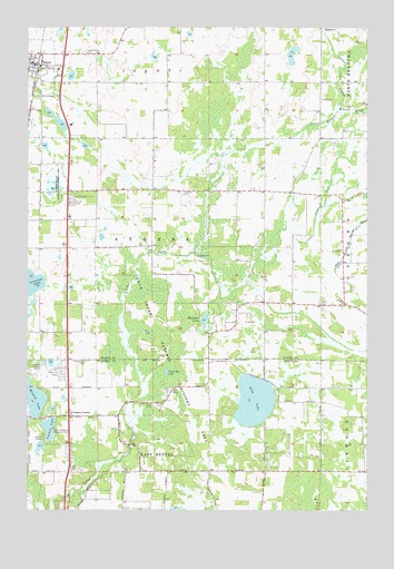
Isanti, MN USGS Topographic Map
Click on map above to begin viewing in our Map Viewer.

This topographic map contains these locations and features:
Feature Name Type Latitude Longitude GNIS ID View Map
Aetna CemeteryCemeteryN45.4283°W93.1426°639222View Map
Athens Lutheran CemeteryCemeteryN45.4570°W93.1933°639494View Map
Athens State Wildlife Management AreaParkN45.4591°W93.2408°639495View Map
Beckman LakeLakeN45.4239°W93.1850°639855View Map
Bible Baptist ChurchChurchN45.3847°W93.2361°2094582View Map
Castle Towers Mobile Home ParkPopulated PlaceN45.4111°W93.2383°2094584View Map
Cedar Bog LakeLakeN45.4105°W93.1991°640987View Map
Cedar Creek Natural History AreaParkN45.4164°W93.1958°659804View Map
City of IsantiCivilN45.4927°W93.2412°2395443View Map
Coopers CornerPopulated PlaceN45.3991°W93.2347°641485View Map
Coopers LakeLakeN45.3960°W93.2420°641486View Map
County Ditch Number ThirteenCanalN45.4333°W93.1316°641656View Map
County Ditch Number TwentyCanalN45.4466°W93.1444°641796View Map
Elim Baptist ChurchChurchN45.4911°W93.2444°2069314View Map
Faith Lutheran ChurchChurchN45.4914°W93.2494°2069313View Map
Fish LakeLakeN45.4032°W93.1666°643681View Map
Fish Lake CemeteryCemeteryN45.4097°W93.1736°2094138View Map
Fridsborg CemeteryCemeteryN45.4137°W93.1829°643956View Map
Gerdin CemeteryCemeteryN45.4561°W93.2344°644088View Map
Ice LakeLakeN45.4211°W93.2073°645326View Map
IsantiLocaleN45.4894°W93.2461°2069308View Map
IsantiPopulated PlaceN45.4902°W93.2477°645470View Map
Isanti City HallBuildingN45.4939°W93.2467°2069295View Map
Isanti EstatesPopulated PlaceN45.4547°W93.2333°2069317View Map
Isanti Fire District Station 1BuildingN45.4934°W93.2480°2069294View Map
Isanti Police DepartmentBuildingN45.4934°W93.2480°2069293View Map
Isanti Post OfficePost OfficeN45.4903°W93.2472°2069309View Map
Isanti Union CemeteryCemeteryN45.4934°W93.2301°645472View Map
John Anderson Memorial ParkParkN45.3944°W93.2399°645664View Map
Laurence Collin Township ParkParkN45.4508°W93.2494°2069305View Map
Minard LakeLakeN45.4039°W93.2479°647901View Map
Old Bethel CemeteryCemeteryN45.4134°W93.2291°648917View Map
Oxford ChurchChurchN45.4291°W93.1341°649104View Map
Saint Andrew Lutheran ChurchChurchN45.3994°W93.2339°2094583View Map
Saint Johns ChurchChurchN45.4800°W93.1258°650725View Map
Township of AthensCivilN45.4408°W93.2253°663470View Map
Unity ParkParkN45.4936°W93.2494°2069292View Map
Veterans of Foreign Wars ParkParkN45.4861°W93.2453°2069306View Map

Note: Coordinates in the location and feature list above are referenced to NAD83 datum.


Copyright (C) 2008-2024 Ryan Niemi / Sunset Dynamics ... All Rights Reserved