TopoQuest Logo
Do you find TopoQuest useful?
Help keep TopoQuest running and adding new maps/features by donating!
Bitcoin:  19c7KJd3qBynnjoSw5npx9KScwjBe4ifkT
Litecoin:  LXs6TkuXGGXo1vDsWCkWVdjQX94eUKd6ui
Home View Maps Find Maps Find Places Resources & Links


Iron Lake, Minnesota Topographic Map

USGS Map Title: Iron Lake, MN
USGS Map MRC: 48091B8
DRG (GeoTIFF) Download: o48091b8.tif


Neighboring USGS Topographic Map Quads:


  Coleman Island, MN  
48092C1


  Lake Agnes, MN  
48092B1
 

  Iron Lake, MN  
48091B8
 

  Friday Bay, MN  
48091B7
 

  Lapond Lake, MN  
48092A1
 

  Angleworm Lake, MN  
48091A8
 

  Fourtown Lake, MN  
48091A7


Map MRC Location:

N49°
W92°
N49°
W91°
H8 H7 H6 H5 H4 H3 H2 H1
G8 G7 G6 G5 G4 G3 G2 G1
F8 F7 F6 F5 F4 F3 F2 F1
E8 E7 E6 E5 E4 E3 E2 E1
D8 D7 D6 D5 D4 D3 D2 D1
C8 C7 C6 C5 C4 C3 C2 C1
B8 B7 B6 B5 B4 B3 B2 B1
A8 A7 A6 A5 A4 A3 A2 A1
N48°
W92°
N48°
W91°

Iron Lake, MN USGS 1:24K Topographic Map Preview:
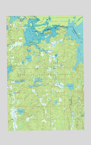
Iron Lake, MN USGS Topographic Map
Click on map above to begin viewing in our Map Viewer.

This topographic map contains these locations and features:
Feature Name Type Latitude Longitude GNIS ID View Map
Beartrap RiverStreamN48.2096°W91.9357°660752View Map
Bibon LakeLakeN48.1789°W91.9753°660785View Map
Bottle RiverStreamN48.2474°W91.9801°660856View Map
Contest LakeLakeN48.1666°W91.9882°661040View Map
Curtain FallsFallsN48.2366°W91.9062°661081View Map
Dark LakeLakeN48.2119°W91.9651°661093View Map
Fox LakeLakeN48.1995°W91.9743°661317View Map
Iron LakeLakeN48.2285°W91.9493°661554View Map
Jerry CreekStreamN48.1393°W91.9904°661583View Map
Nibin LakeLakeN48.1783°W91.9844°662046View Map
Parley LakeLakeN48.2066°W91.9197°662141View Map
Peterson BayBayN48.2163°W91.9507°662163View Map
Rush LakeLakeN48.2036°W91.9646°662312View Map
Spring CreekStreamN48.1435°W91.8943°662514View Map
Sterling CreekStreamN48.1746°W91.9193°662546View Map
Sterling LakeLakeN48.1741°W91.9531°662547View Map
Sunday LakeLakeN48.1726°W91.8973°662591View Map
Sundial LakeLakeN48.1556°W91.9213°662592View Map
Three IslandIslandN48.2327°W91.9324°662639View Map
White Feather LakeLakeN48.1463°W91.9792°662787View Map

Note: Coordinates in the location and feature list above are referenced to NAD83 datum.


Copyright (C) 2008-2024 Ryan Niemi / Sunset Dynamics ... All Rights Reserved