TopoQuest Logo
Do you find TopoQuest useful?
Help keep TopoQuest running and adding new maps/features by donating!
Bitcoin:  19c7KJd3qBynnjoSw5npx9KScwjBe4ifkT
Litecoin:  LXs6TkuXGGXo1vDsWCkWVdjQX94eUKd6ui
Home View Maps Find Maps Find Places Resources & Links


Hugo, Minnesota Topographic Map

USGS Map Title: Hugo, MN
USGS Map MRC: 45092B8
DRG (GeoTIFF) Download: o45092b8.tif


Neighboring USGS Topographic Map Quads:


  Linwood, MN  
45093C1
 

  Forest Lake, MN  
45092C8
 

  Scandia, MN  
45092C7
 

  Centerville, MN  
45093B1
 

  Hugo, MN  
45092B8
 

  Marine on St. Croix, MN  
45092B7
 

  White Bear Lake West, MN  
45093A1
 

  White Bear Lake East, MN  
45092A8
 

  Stillwater, MN  
45092A7


Map MRC Location:

N46°
W93°
N46°
W92°
H8 H7 H6 H5 H4 H3 H2 H1
G8 G7 G6 G5 G4 G3 G2 G1
F8 F7 F6 F5 F4 F3 F2 F1
E8 E7 E6 E5 E4 E3 E2 E1
D8 D7 D6 D5 D4 D3 D2 D1
C8 C7 C6 C5 C4 C3 C2 C1
B8 B7 B6 B5 B4 B3 B2 B1
A8 A7 A6 A5 A4 A3 A2 A1
N45°
W93°
N45°
W92°

Hugo, MN USGS 1:24K Topographic Map Preview:
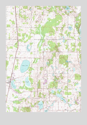
Hugo, MN USGS Topographic Map
Click on map above to begin viewing in our Map Viewer.

This topographic map contains these locations and features:
Feature Name Type Latitude Longitude GNIS ID View Map
Barker LakeLakeN45.1841°W92.8964°639629View Map
Campfire Girls CampLocaleN45.1869°W92.9255°659644View Map
City of HugoCivilN45.1671°W92.9588°2394440View Map
Egg LakeLakeN45.1576°W92.9888°643194View Map
Forest Lake AirportAirportN45.2478°W92.9944°660167View Map
Goggins LakeLakeN45.1330°W92.8934°644195View Map
Horseshoe LakeLakeN45.1997°W92.9630°645212View Map
Hosanna Lutheran ChurchChurchN45.1475°W92.9861°2097809View Map
HugoLocaleN45.1639°W92.9925°2097808View Map
HugoPopulated PlaceN45.1600°W92.9933°659709View Map
Hugo City HallBuildingN45.1619°W92.9939°2097811View Map
Hugo Elementary SchoolSchoolN45.1658°W92.9872°2097810View Map
Hugo Fire DepartmentBuildingN45.1521°W92.9983°2097812View Map
Hugo Post OfficePost OfficeN45.1663°W92.9922°2097817View Map
Jehovah's Witnesses CongregationChurchN45.2036°W92.9783°2097805View Map
Kelly Farms DamDamN45.1716°W92.8885°1777031View Map
Lake KeewahtinLakeN45.2484°W92.8983°644575View Map
Long LakeLakeN45.1333°W92.9243°647047View Map
Lynch LakeLakeN45.1481°W92.8763°647327View Map
Maple Marsh LakeReservoirN45.1748°W92.8870°1777032View Map
New Life Lutheran ChurchChurchN45.1647°W92.9856°2097813View Map
North School Section LakeLakeN45.1448°W92.9112°648689View Map
Oneka LakeLakeN45.1794°W92.9686°648972View Map
Oneka Ridge Golf CourseLocaleN45.1264°W92.9889°2097785View Map
Plaisted LakeLakeN45.1507°W92.9113°654548View Map
Rice LakeLakeN45.1609°W92.9642°649987View Map
Round LakeLakeN45.1258°W92.9334°650358View Map
Saint John the Baptist ChurchChurchN45.1578°W92.9931°2097815View Map
Saint John's CemeteryCemeteryN45.1641°W92.9960°650678View Map
School Section LakeLakeN45.1394°W92.9046°651774View Map
Sunset LakeLakeN45.1335°W92.9423°652852View Map
Tanners Brook Golf CourseLocaleN45.2222°W92.9889°2097836View Map
Twin Pine Mobile Home ParkPopulated PlaceN45.1681°W92.9889°2097816View Map
Veterans Rest CampLocaleN45.2091°W92.8766°659645View Map
WestonPopulated PlaceN45.1889°W92.9847°654035View Map
White Bear Lake ChurchChurchN45.1672°W92.9897°2097814View Map
White Rock LakeLakeN45.2233°W92.8925°654093View Map
Withrow CemeteryCemeteryN45.1269°W92.8919°654294View Map
Withrow Elementary SchoolSchoolN45.1282°W92.9017°654295View Map

Note: Coordinates in the location and feature list above are referenced to NAD83 datum.


Copyright (C) 2008-2024 Ryan Niemi / Sunset Dynamics ... All Rights Reserved