TopoQuest Logo
Do you find TopoQuest useful?
Help keep TopoQuest running and adding new maps/features by donating!
Bitcoin:  19c7KJd3qBynnjoSw5npx9KScwjBe4ifkT
Litecoin:  LXs6TkuXGGXo1vDsWCkWVdjQX94eUKd6ui
Home View Maps Find Maps Find Places Resources & Links


Hubbard Lake, Missouri Topographic Map

USGS Map Title: Hubbard Lake, MO
USGS Map MRC: 36089E4
DRG (GeoTIFF) Download: o36089e4.tif


Neighboring USGS Topographic Map Quads:


  Kewanee, MO  
36089F5
 

  Henderson Mound, MO  
36089F4
 

  Bayouville, MO  
36089F3
 

  New Madrid, MO  
36089E5
 

  Hubbard Lake, MO  
36089E4
 

  Bondurant, KY  
36089E3
 

  Point Pleasant, MO  
36089D5
 

  Tiptonville, TN  
36089D4
 

  Samburg, TN  
36089D3


Map MRC Location:

N37°
W90°
N37°
W89°
H8 H7 H6 H5 H4 H3 H2 H1
G8 G7 G6 G5 G4 G3 G2 G1
F8 F7 F6 F5 F4 F3 F2 F1
E8 E7 E6 E5 E4 E3 E2 E1
D8 D7 D6 D5 D4 D3 D2 D1
C8 C7 C6 C5 C4 C3 C2 C1
B8 B7 B6 B5 B4 B3 B2 B1
A8 A7 A6 A5 A4 A3 A2 A1
N36°
W90°
N36°
W89°

Hubbard Lake, MO USGS 1:24K Topographic Map Preview:
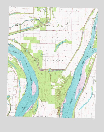
Hubbard Lake, MO USGS Topographic Map
Click on map above to begin viewing in our Map Viewer.

This topographic map contains these locations and features:
Feature Name Type Latitude Longitude GNIS ID View Map
Adams CemeteryCemeteryN36.5123°W89.4928°485756View Map
Ash LogPopulated PlaceN36.5600°W89.3794°2743886View Map
Bowman HoleLakeN36.5541°W89.4305°714589View Map
Chute of Island Number 8StreamN36.5762°W89.3831°517110View Map
Conran DikeLeveeN36.5459°W89.4379°716205View Map
Conran Dike HoleLakeN36.5538°W89.4407°716206View Map
Cutoff SloughGutN36.5167°W89.4495°716615View Map
Dawson HoleLakeN36.5751°W89.4736°716750View Map
Elbow SloughGutN36.5442°W89.3770°491612View Map
Fish LakeLakeN36.5715°W89.4531°717939View Map
Hancock HoleLakeN36.6094°W89.3888°737960View Map
Harris LightBuildingN36.5501°W89.3834°517048View Map
Henderson LandingLocaleN36.5876°W89.3859°741740View Map
Higgerson School (historical)SchoolN36.5878°W89.3981°746835View Map
Hotchkiss BendChannelN36.5501°W89.4629°737962View Map
Hotchkiss LandingLocaleN36.5034°W89.4740°741742View Map
Hubbard LakeLakeN36.5833°W89.4267°719940View Map
Island Number 9IslandN36.5256°W89.3904°517191View Map
Kentucky BendBendN36.5396°W89.4761°2743906View Map
Kentucky PointCapeN36.5698°W89.4979°495676View Map
Knotts BridgeBridgeN36.6112°W89.4631°730304View Map
La Forge LandingLocaleN36.5153°W89.4606°741741View Map
La Forge Revetment (historical)LeveeN36.5703°W89.4779°737975View Map
Lake Number 9LakeN36.5163°W89.3896°517203View Map
Madrid Bend ChurchChurchN36.5126°W89.4923°497445View Map
Morrison HoleLakeN36.5872°W89.4928°722658View Map
Morrison LandingLocaleN36.5812°W89.4923°736020View Map
Mud DitchCanalN36.6001°W89.4654°730161View Map
New Madrid Farrenburg LeveeLeveeN36.6217°W89.4629°723283View Map
Newsom LandingLocaleN36.5786°W89.3914°736178View Map
Ransburgh HoleLakeN36.6012°W89.4726°725105View Map
Riley LakeLakeN36.5125°W89.4574°725309View Map
Round HoleLakeN36.5653°W89.4576°725601View Map
Spies Landing (historical)LocaleN36.5687°W89.3956°746836View Map
Stonewall LakeLakeN36.5357°W89.4825°504489View Map
Stump HoleLakeN36.5889°W89.3954°727202View Map
T Louis BayouStreamN36.6042°W89.4151°727428View Map
Township of Saint JohnCivilN36.5950°W89.4164°767068View Map
Tressle HoleLakeN36.5539°W89.4514°727770View Map
Washpan LakeLakeN36.5225°W89.4987°506252View Map
Whitson CemeteryCemeteryN36.5047°W89.4911°506694View Map
Wilson BayouStreamN36.6053°W89.4270°728954View Map

Note: Coordinates in the location and feature list above are referenced to NAD83 datum.


Copyright (C) 2008-2024 Ryan Niemi / Sunset Dynamics ... All Rights Reserved