TopoQuest Logo
Do you find TopoQuest useful?
Help keep TopoQuest running and adding new maps/features by donating!
Bitcoin:  19c7KJd3qBynnjoSw5npx9KScwjBe4ifkT
Litecoin:  LXs6TkuXGGXo1vDsWCkWVdjQX94eUKd6ui
Home View Maps Find Maps Find Places Resources & Links


Bagley Lake, Mississippi Topographic Map

USGS Map Title: Bagley Lake, MS
USGS Map MRC: 34089D4
DRG (GeoTIFF) Download: o34089d4.tif


Neighboring USGS Topographic Map Quads:


  Laws Hill, MS  
34089E5
 

  Malone, MS  
34089E4
 

  Bethlehem, MS  
34089E3
 

  Oxford North, MS  
34089D5
 

  Bagley Lake, MS  
34089D4
 

  Puskus Lake, MS  
34089D3
 

  Oxford South, MS  
34089C5
 

  Yocona, MS  
34089C4
 

  Denmark, MS  
34089C3


Map MRC Location:

N35°
W90°
N35°
W89°
H8 H7 H6 H5 H4 H3 H2 H1
G8 G7 G6 G5 G4 G3 G2 G1
F8 F7 F6 F5 F4 F3 F2 F1
E8 E7 E6 E5 E4 E3 E2 E1
D8 D7 D6 D5 D4 D3 D2 D1
C8 C7 C6 C5 C4 C3 C2 C1
B8 B7 B6 B5 B4 B3 B2 B1
A8 A7 A6 A5 A4 A3 A2 A1
N34°
W90°
N34°
W89°

Bagley Lake, MS USGS 1:24K Topographic Map Preview:
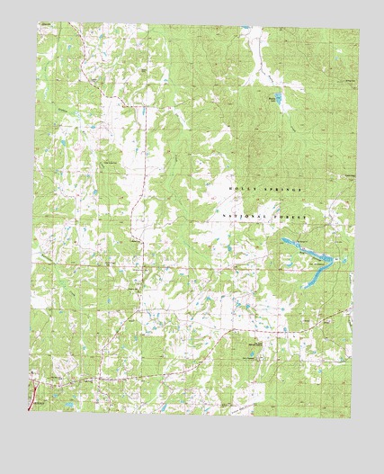
Bagley Lake, MS USGS Topographic Map
Click on map above to begin viewing in our Map Viewer.

This topographic map contains these locations and features:
Feature Name Type Latitude Longitude GNIS ID View Map
Adams Store (historical)LocaleN34.4376°W89.3848°704811View Map
Anderson Chapel (historical)ChurchN34.4740°W89.4445°704812View Map
Avent Lake DamDamN34.3784°W89.4817°695577View Map
Bagley LakeReservoirN34.4774°W89.4059°704814View Map
Bay Springs BranchStreamN34.4276°W89.3798°692477View Map
Bay Springs ChurchChurchN34.4309°W89.4004°692478View Map
Brazil Lake DamDamN34.4101°W89.4717°695584View Map
Cambridge SchoolSchoolN34.4512°W89.3795°692804View Map
Camp HopewellLocaleN34.3932°W89.4126°704822View Map
Cedar Grove CemeteryCemeteryN34.4557°W89.4717°704825View Map
Christ United ChurchChurchN34.3857°W89.4754°704827View Map
Corner Church (historical)ChurchN34.4373°W89.4362°704830View Map
Corner SchoolSchoolN34.4387°W89.4390°692977View Map
Cullen School (historical)SchoolN34.3843°W89.4970°704834View Map
First Free Will Baptist ChurchChurchN34.3857°W89.4873°704840View Map
Greenville ChurchChurchN34.4548°W89.4751°693363View Map
Greenville SchoolSchoolN34.4229°W89.4790°693364View Map
Gunter Lake DamDamN34.4618°W89.4867°682653View Map
Holder School (historical)SchoolN34.4429°W89.4098°704845View Map
Hopewell ChurchChurchN34.3937°W89.4115°704846View Map
Hopewell SchoolSchoolN34.3926°W89.4148°693529View Map
Jefferson ChapelChurchN34.4815°W89.4792°704849View Map
Jefferson SchoolSchoolN34.4818°W89.4804°693607View Map
Kingdom HallChurchN34.4145°W89.4584°704854View Map
Lafayette County Volunteer Fire Department Station 2BuildingN34.3868°W89.4534°2666022View Map
Little John Store (historical)LocaleN34.4257°W89.4079°704859View Map
LT 15-1 DamDamN34.4768°W89.4051°695588View Map
Martin CemeteryCemeteryN34.4304°W89.4620°704861View Map
Midway CemeteryCemeteryN34.4834°W89.3803°704863View Map
Midway ChurchChurchN34.4840°W89.3854°693961View Map
Mitchells School (historical)SchoolN34.4448°W89.4481°704865View Map
Oak Grove Memorial GardensCemeteryN34.3984°W89.4084°704870View Map
Owens CemeteryCemeteryN34.4848°W89.4598°704872View Map
Oxford Elementary SchoolSchoolN34.3876°W89.4987°706734View Map
Oxford Work CenterBuildingN34.3868°W89.4537°711521View Map
Philadelphia Missionary ChurchChurchN34.3784°W89.4254°704876View Map
Philadelphia SchoolSchoolN34.3782°W89.4270°694357View Map
Saint Peters ChurchChurchN34.4209°W89.4567°704887View Map
Smiths ChapelChurchN34.4229°W89.4717°704891View Map
Stuart Lake DamDamN34.4468°W89.4751°695587View Map
Tidwell School (historical)SchoolN34.4807°W89.4654°704899View Map
Violet Hill School (historical)SchoolN34.4634°W89.4165°704903View Map
Woodland Hills EstatesPopulated PlaceN34.4001°W89.4973°704905View Map

Note: Coordinates in the location and feature list above are referenced to NAD83 datum.


Copyright (C) 2008-2024 Ryan Niemi / Sunset Dynamics ... All Rights Reserved