TopoQuest Logo
Do you find TopoQuest useful?
Help keep TopoQuest running and adding new maps/features by donating!
Bitcoin:  19c7KJd3qBynnjoSw5npx9KScwjBe4ifkT
Litecoin:  LXs6TkuXGGXo1vDsWCkWVdjQX94eUKd6ui
Home View Maps Find Maps Find Places Resources & Links


Honey Island, Wisconsin Topographic Map

USGS Map Title: Honey Island, WI
USGS Map MRC: 44089F8
DRG (GeoTIFF) Download: o44089f8.tif


Neighboring USGS Topographic Map Quads:


  Stratford, WI  
44090G1
 

  Marathon SW, WI  
44089G8
 

  Halder, WI  
44089G7
 

  Hewitt, WI  
44090F1
 

  Honey Island, WI  
44089F8
 

  Big Eau Pleine Reservoir, WI  
44089F7
 

  Arpin, WI  
44090E1
 

  Sherry, WI  
44089E8
 

  Junction City, WI  
44089E7


Map MRC Location:

N45°
W90°
N45°
W89°
H8 H7 H6 H5 H4 H3 H2 H1
G8 G7 G6 G5 G4 G3 G2 G1
F8 F7 F6 F5 F4 F3 F2 F1
E8 E7 E6 E5 E4 E3 E2 E1
D8 D7 D6 D5 D4 D3 D2 D1
C8 C7 C6 C5 C4 C3 C2 C1
B8 B7 B6 B5 B4 B3 B2 B1
A8 A7 A6 A5 A4 A3 A2 A1
N44°
W90°
N44°
W89°

Honey Island, WI USGS 1:24K Topographic Map Preview:
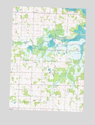
Honey Island, WI USGS Topographic Map
Click on map above to begin viewing in our Map Viewer.

This topographic map contains these locations and features:
Feature Name Type Latitude Longitude GNIS ID View Map
Bear CreekStreamN44.7075°W89.8751°1561360View Map
Beth Arthur Lane Pond Number 3LakeN44.6890°W89.9730°2770683View Map
Brandt FarmLocaleN44.7344°W89.9047°2723849View Map
Carey School (historical)SchoolN44.6869°W89.9265°1844067View Map
Fisher FlowageReservoirN44.7296°W89.8763°1565013View Map
Grace ChurchChurchN44.7427°W89.9071°1565693View Map
Honey IslandIslandN44.7008°W89.8907°1566655View Map
Honey Island FlowageReservoirN44.6997°W89.8813°1566656View Map
Little Bear CreekStreamN44.6672°W89.9060°1568189View Map
McKinley School (historical)SchoolN44.7286°W89.9840°1844191View Map
North Honey Island FlowageReservoirN44.7132°W89.8854°1570448View Map
North Rice LakeLakeN44.7149°W89.9341°1570488View Map
North Smoky Hill FlowageReservoirN44.7135°W89.9161°1570503View Map
Phillip School (historical)SchoolN44.7425°W89.9165°1845224View Map
RangelinePopulated PlaceN44.7436°W89.9640°1572074View Map
Rangeline FlowageReservoirN44.7000°W89.9680°1572075View Map
Sixteen PoolReservoirN44.6808°W89.8770°1571763View Map
Smoky HillSummitN44.7080°W89.9215°1574325View Map
Smoky Hill FlowageReservoirN44.7107°W89.9100°1574326View Map
Soapstone PitBasinN44.6480°W89.9004°1574357View Map
South Rice LakeLakeN44.7061°W89.9324°1574483View Map
Sunshine School (historical)SchoolN44.6564°W89.9635°1847122View Map
Teal FlowageReservoirN44.7227°W89.8805°1575289View Map
Ten PoolReservoirN44.6954°W89.9199°1571764View Map
Town of Green ValleyCivilN44.7282°W89.9046°1583320View Map
Town of MilladoreCivilN44.6426°W89.9061°1583716View Map
West Honey Island FlowageReservoirN44.7050°W89.9106°1576516View Map

Note: Coordinates in the location and feature list above are referenced to NAD83 datum.


Copyright (C) 2008-2024 Ryan Niemi / Sunset Dynamics ... All Rights Reserved