TopoQuest Logo
Do you find TopoQuest useful?
Help keep TopoQuest running and adding new maps/features by donating!
Bitcoin:  19c7KJd3qBynnjoSw5npx9KScwjBe4ifkT
Litecoin:  LXs6TkuXGGXo1vDsWCkWVdjQX94eUKd6ui
Home View Maps Find Maps Find Places Resources & Links


Homer, New York Topographic Map

USGS Map Title: Homer, NY
USGS Map MRC: 42076F2
DRG (GeoTIFF) Download: o42076f2.tif


Neighboring USGS Topographic Map Quads:


  Spafford, NY  
42076G3
 

  Otisco Valley, NY  
42076G2
 

  Tully, NY  
42076G1
 

  Sempronius, NY  
42076F3
 

  Homer, NY  
42076F2
 

  Truxton, NY  
42076F1
 

  Groton, NY  
42076E3
 

  Cortland, NY  
42076E2
 

  McGraw, NY  
42076E1


Map MRC Location:

N43°
W77°
N43°
W76°
H8 H7 H6 H5 H4 H3 H2 H1
G8 G7 G6 G5 G4 G3 G2 G1
F8 F7 F6 F5 F4 F3 F2 F1
E8 E7 E6 E5 E4 E3 E2 E1
D8 D7 D6 D5 D4 D3 D2 D1
C8 C7 C6 C5 C4 C3 C2 C1
B8 B7 B6 B5 B4 B3 B2 B1
A8 A7 A6 A5 A4 A3 A2 A1
N42°
W77°
N42°
W76°

Homer, NY USGS 1:24K Topographic Map Preview:
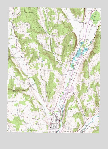
Homer, NY USGS Topographic Map
Click on map above to begin viewing in our Map Viewer.

This topographic map contains these locations and features:
Feature Name Type Latitude Longitude GNIS ID View Map
Atwater CemeteryCemeteryN42.6719°W76.2176°942682View Map
BaltimorePopulated PlaceN42.7353°W76.1258°942957View Map
Brake HillSummitN42.7001°W76.2074°944606View Map
Brook CemeteryCemeteryN42.7497°W76.2004°944828View Map
Callan CreekStreamN42.7251°W76.1966°945474View Map
Calvary Baptist ChurchChurchN42.7356°W76.1504°2615659View Map
Calvary Episcopal ChurchChurchN42.6361°W76.1797°2371814View Map
Cold BrookStreamN42.6820°W76.1646°947034View Map
Corl HillSummitN42.6692°W76.1438°947450View Map
Cortland County HomeBuildingN42.6272°W76.1464°2371576View Map
Cosmos HillSummitN42.6301°W76.2094°947507View Map
Dry CreekStreamN42.7492°W76.1319°977527View Map
East HillSummitN42.6487°W76.1655°949115View Map
East ScottPopulated PlaceN42.7220°W76.1944°972430View Map
Elizabeth Brewster HouseBuildingN42.6354°W76.1780°2614640View Map
Elmwood CemeteryCemeteryN42.7392°W76.1457°949592View Map
Factory BrookStreamN42.6420°W76.1749°949795View Map
Fairview Health Campus (historical)LocaleN42.6619°W76.1608°2108294View Map
First Baptist ChurchChurchN42.6342°W76.1794°2371816View Map
First Congregational ChurchChurchN42.6353°W76.1800°2371812View Map
First Methodist ChurchChurchN42.6350°W76.1800°2371811View Map
Forbes FarmsLocaleN42.6469°W76.1281°2706514View Map
Gillett CemeteryCemeteryN42.7202°W76.1940°951119View Map
Glenwood CemeteryCemeteryN42.6328°W76.1925°951241View Map
Goodale LakeLakeN42.7078°W76.1456°951320View Map
Green LakeLakeN42.7147°W76.1504°951698View Map
Greenbriar Home for AdultsBuildingN42.6322°W76.1832°2614659View Map
HomerPopulated PlaceN42.6370°W76.1788°953124View Map
Homer Academy And Union SchoolSchoolN42.6358°W76.1806°2371813View Map
Homer Drive-In (historical)LocaleN42.6658°W76.1625°2558430View Map
Homer Elementary SchoolSchoolN42.6300°W76.1911°2668862View Map
Homer Fire DepartmentBuildingN42.6350°W76.1783°2700921View Map
Homer GreenParkN42.6353°W76.1792°2371810View Map
Homer GulfValleyN42.6709°W76.2197°953126View Map
Homer Intermediate SchoolSchoolN42.6436°W76.1833°2669162View Map
Homer Junior High SchoolSchoolN42.6430°W76.1828°2669163View Map
Homer Post OfficePost OfficeN42.6367°W76.1789°2617969View Map
Homer Senior High SchoolSchoolN42.6305°W76.1908°2669220View Map
Homer Town HallBuildingN42.6389°W76.1781°2371815View Map
Houghton HillSummitN42.6856°W76.2385°953286View Map
J View FarmsLocaleN42.6281°W76.2397°2706518View Map
Little YorkPopulated PlaceN42.6959°W76.1644°955736View Map
Little York Post OfficePost OfficeN42.6967°W76.1639°2618004View Map
Loring CrossingPopulated PlaceN42.6259°W76.1455°955998View Map
Lower Little York LakeLakeN42.6920°W76.1632°956091View Map
Mount ToppinSummitN42.7195°W76.1635°974775View Map
New Hope View FarmLocaleN42.6933°W76.1544°2519075View Map
Parker ManorPopulated PlaceN42.7206°W76.2397°2514386View Map
Phillips Free LibraryBuildingN42.6356°W76.1783°2371809View Map
Pine Hill Mobile Home ParkPopulated PlaceN42.6578°W76.1700°2514385View Map
Pratt CornersPopulated PlaceN42.6876°W76.1688°961096View Map
PreblePopulated PlaceN42.7353°W76.1483°961107View Map
Preble Congregational ChurchChurchN42.7354°W76.1461°2616804View Map
Preble Fire DepartmentBuildingN42.7358°W76.1491°2701086View Map
Preble Hill FarmsLocaleN42.7453°W76.1731°2707060View Map
Preble Post OfficePost OfficeN42.7345°W76.1453°2618078View Map
Preble Rest AreaLocaleN42.7153°W76.1457°2615126View Map
Saint Margaret's Roman Catholic ChurchChurchN42.6292°W76.1822°2371817View Map
School Number 1 (historical)SchoolN42.7047°W76.1908°2108297View Map
School Number 10 (historical)SchoolN42.6253°W76.2453°2108316View Map
School Number 10 (historical)SchoolN42.6253°W76.2453°2108319View Map
School Number 10 (historical)SchoolN42.6731°W76.1625°2108322View Map
School Number 11 (historical)SchoolN42.6778°W76.1347°2108325View Map
School Number 2 (historical)SchoolN42.6825°W76.2231°2108300View Map
School Number 3 (historical)SchoolN42.6272°W76.1431°2108302View Map
School Number 3 (historical)SchoolN42.6867°W76.2033°2108305View Map
School Number 4 (historical)SchoolN42.6403°W76.2242°2108308View Map
School Number 4 (historical)SchoolN42.7189°W76.1350°2108311View Map
School Number 6 (historical)SchoolN42.7342°W76.1453°2108313View Map
School Number 8 (historical)SchoolN42.6608°W76.2042°2108314View Map
ScottPopulated PlaceN42.7295°W76.2433°964673View Map
Scott SchoolSchoolN42.7362°W76.2447°964683View Map
Scott Union CemeteryCemeteryN42.7209°W76.2431°964684View Map
Sessions Hill Neighborhood CemeteryCemeteryN42.6798°W76.1306°2541926View Map
Seven Day Baptist CemeteryCemeteryN42.7346°W76.2451°2541924View Map
Slab CityPopulated PlaceN42.7187°W76.1349°965377View Map
Town of HomerCivilN42.6660°W76.1699°979071View Map
Town of PrebleCivilN42.7430°W76.1320°979397View Map
Town of ScottCivilN42.7346°W76.2281°979477View Map
Upper Little York LakeLakeN42.7033°W76.1558°968283View Map
Valley View GardensLocaleN42.6500°W76.2356°2519069View Map
Village of HomerCivilN42.6371°W76.1849°2390902View Map
Vrooman GulfValleyN42.6995°W76.2399°968614View Map
West Side Hose Company (historical)BuildingN42.6389°W76.1900°2371818View Map
Westan FarmsLocaleN42.6597°W76.1833°2707061View Map
Wineland FarmLocaleN42.6289°W76.1378°2519072View Map

Note: Coordinates in the location and feature list above are referenced to NAD83 datum.


Copyright (C) 2008-2024 Ryan Niemi / Sunset Dynamics ... All Rights Reserved