TopoQuest Logo
Do you find TopoQuest useful?
Help keep TopoQuest running and adding new maps/features by donating!
Bitcoin:  19c7KJd3qBynnjoSw5npx9KScwjBe4ifkT
Litecoin:  LXs6TkuXGGXo1vDsWCkWVdjQX94eUKd6ui
Home View Maps Find Maps Find Places Resources & Links


Holmesville, Ohio Topographic Map

USGS Map Title: Holmesville, OH
USGS Map MRC: 40081F8
DRG (GeoTIFF) Download: o40081f8.tif


Neighboring USGS Topographic Map Quads:


  New Pittsburg, OH  
40082G1
 

  Wooster, OH  
40081G8
 

  Orrville, OH  
40081G7
 

  Shreve, OH  
40082F1
 

  Holmesville, OH  
40081F8
 

  Fredericksburg, OH  
40081F7
 

  Glenmont, OH  
40082E1
 

  Millersburg, OH  
40081E8
 

  Berlin, OH  
40081E7


Map MRC Location:

N41°
W82°
N41°
W81°
H8 H7 H6 H5 H4 H3 H2 H1
G8 G7 G6 G5 G4 G3 G2 G1
F8 F7 F6 F5 F4 F3 F2 F1
E8 E7 E6 E5 E4 E3 E2 E1
D8 D7 D6 D5 D4 D3 D2 D1
C8 C7 C6 C5 C4 C3 C2 C1
B8 B7 B6 B5 B4 B3 B2 B1
A8 A7 A6 A5 A4 A3 A2 A1
N40°
W82°
N40°
W81°

Holmesville, OH USGS 1:24K Topographic Map Preview:
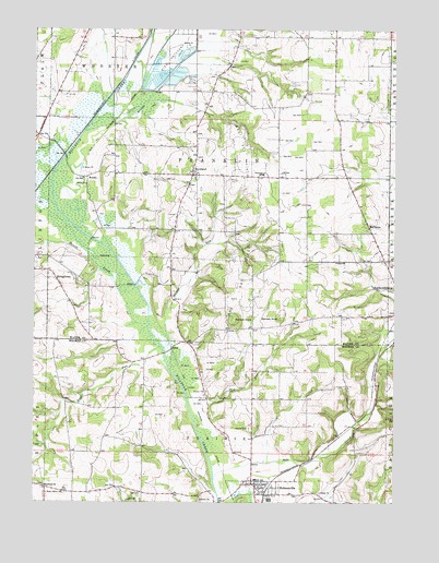
Holmesville, OH USGS Topographic Map
Click on map above to begin viewing in our Map Viewer.

This topographic map contains these locations and features:
Feature Name Type Latitude Longitude GNIS ID View Map
Big HollowValleyN40.6723°W81.9543°1069669View Map
Bottom Run FarmsLocaleN40.6908°W81.8842°2709725View Map
Dalroy FarmsLocaleN40.6539°W81.9708°2709756View Map
Davies Air FieldAirportN40.7369°W81.8752°1083138View Map
Dush PondReservoirN40.7384°W81.9749°1079522View Map
Dush Pond DamDamN40.7384°W81.9749°1079521View Map
Franklin Elementary SchoolSchoolN40.7117°W81.9213°1081326View Map
Franks CemeteryCemeteryN40.7106°W81.9057°1730957View Map
Gress Family FarmLocaleN40.7211°W81.9567°2709592View Map
HardPopulated PlaceN40.6656°W81.9524°1062803View Map
Hard Post Office (historical)Post OfficeN40.6653°W81.9526°2013569View Map
Hawk HavenLocaleN40.7422°W81.9689°2709623View Map
Hazeldell School (historical)SchoolN40.6776°W81.9882°1053765View Map
Hermans CemeteryCemeteryN40.7342°W81.9062°1730961View Map
HolmesvillePopulated PlaceN40.6295°W81.9243°1064852View Map
Holmesville Elementary SchoolSchoolN40.6312°W81.9229°1056052View Map
Holmesville Post OfficePost OfficeN40.6289°W81.9225°2013561View Map
Jennings DitchCanalN40.7403°W81.9510°1042083View Map
KaukePopulated PlaceN40.7109°W81.9824°1064919View Map
Killbuck Marsh State Wildlife AreaParkN40.6912°W81.9760°1054773View Map
Killbuck SwampSwampN40.7011°W81.9919°1065841View Map
McCancePopulated PlaceN40.6978°W81.8840°1048956View Map
Mill Brook Stock FarmLocaleN40.7267°W81.9929°1730998View Map
Moorhead ChurchChurchN40.6292°W81.9963°1043475View Map
Morehead CemeteryCemeteryN40.6298°W81.9960°1961603View Map
MorelandPopulated PlaceN40.7126°W81.9443°1065469View Map
Moreland CemeteryCemeteryN40.7120°W81.9435°1730968View Map
Moreland Fruit FarmLocaleN40.7086°W81.9672°2544530View Map
Munson FarmLocaleN40.6864°W81.9414°2709766View Map
Munson KnobSummitN40.6731°W81.9296°1066270View Map
Norway FarmsLocaleN40.6842°W81.9253°2709722View Map
Oak Grove School (historical)SchoolN40.6473°W81.9718°1053500View Map
Prairie CemeteryCemeteryN40.6445°W81.9251°1044741View Map
Prairie Township Volunteer Fire DepartmentBuildingN40.6305°W81.9221°2549953View Map
Rock Point School (historical)SchoolN40.6467°W81.8882°1053498View Map
Rush RunStreamN40.6659°W81.9560°1066178View Map
Salt CreekStreamN40.6309°W81.9376°1058004View Map
Savage RunStreamN40.6601°W81.9529°1045977View Map
Scheufler FarmLocaleN40.7286°W81.8844°2709504View Map
School Number 1 (historical)SchoolN40.7476°W81.8954°1053760View Map
School Number 2 (historical)SchoolN40.7476°W81.9296°1053763View Map
School Number 4 (historical)SchoolN40.7112°W81.9149°1053761View Map
School Number 5 (historical)SchoolN40.6826°W81.9149°1053762View Map
School Number 6 (historical)SchoolN40.6839°W81.9413°1053764View Map
Shreve CreekStreamN40.6720°W81.9604°1066200View Map
Sterrett KnobSummitN40.6739°W81.9151°1049210View Map
Stine FieldAirportN40.7335°W81.8952°1083137View Map
Stoney Meadow FarmLocaleN40.7381°W81.9086°2709593View Map
StringtownPopulated PlaceN40.6834°W81.9921°1049220View Map
Sunset MeadowsLocaleN40.6714°W81.9908°2709763View Map
Tea RunStreamN40.6523°W81.9471°1046976View Map
Tea Run School (historical)SchoolN40.6523°W81.9240°1053499View Map
Township of FranklinCivilN40.7119°W81.9287°1087155View Map
Township of PrairieCivilN40.6316°W81.9364°1086335View Map
Trinity English Lutheran CemeteryCemeteryN40.7331°W81.9060°1730978View Map
Village of HolmesvilleCivilN40.6290°W81.9233°2398530View Map
West Prairie CemeteryCemeteryN40.6277°W81.9891°1047795View Map
Will Del FarmLocaleN40.6914°W81.9508°2709768View Map
Wirth FarmLocaleN40.7458°W81.9239°2709579View Map

Note: Coordinates in the location and feature list above are referenced to NAD83 datum.


Copyright (C) 2008-2024 Ryan Niemi / Sunset Dynamics ... All Rights Reserved