TopoQuest Logo
Do you find TopoQuest useful?
Help keep TopoQuest running and adding new maps/features by donating!
Bitcoin:  19c7KJd3qBynnjoSw5npx9KScwjBe4ifkT
Litecoin:  LXs6TkuXGGXo1vDsWCkWVdjQX94eUKd6ui
Home View Maps Find Maps Find Places Resources & Links


Hillham, Indiana Topographic Map

USGS Map Title: Hillham, IN
USGS Map MRC: 38086E6
DRG (GeoTIFF) Download: o38086e6.tif


Neighboring USGS Topographic Map Quads:


  Shoals, IN  
38086F7
 

  Huron, IN  
38086F6
 

  Georgia, IN  
38086F5
 

  Rusk, IN  
38086E7
 

  Hillham, IN  
38086E6
 

  French Lick, IN  
38086E5
 

  Dubois, IN  
38086D7
 

  Cuzco, IN  
38086D6
 

  Greenbrier, IN  
38086D5


Map MRC Location:

N39°
W87°
N39°
W86°
H8 H7 H6 H5 H4 H3 H2 H1
G8 G7 G6 G5 G4 G3 G2 G1
F8 F7 F6 F5 F4 F3 F2 F1
E8 E7 E6 E5 E4 E3 E2 E1
D8 D7 D6 D5 D4 D3 D2 D1
C8 C7 C6 C5 C4 C3 C2 C1
B8 B7 B6 B5 B4 B3 B2 B1
A8 A7 A6 A5 A4 A3 A2 A1
N38°
W87°
N38°
W86°

Hillham, IN USGS 1:24K Topographic Map Preview:
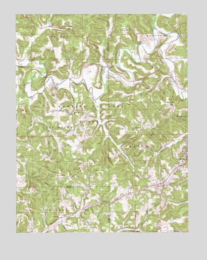
Hillham, IN USGS Topographic Map
Click on map above to begin viewing in our Map Viewer.

This topographic map contains these locations and features:
Feature Name Type Latitude Longitude GNIS ID View Map
Anderson CemeteryCemeteryN38.5698°W86.7222°430154View Map
Big CreekStreamN38.5956°W86.7458°450679View Map
Buck CreekStreamN38.5781°W86.7378°431713View Map
Burton CemeteryCemeteryN38.5059°W86.7080°431878View Map
Coal Mine RidgeRidgeN38.5245°W86.7297°432710View Map
Cornel CemeteryCemeteryN38.5550°W86.7397°432978View Map
Emmons RidgeRidgeN38.5339°W86.7064°434189View Map
Emmons Ridge CemeteryCemeteryN38.5398°W86.7014°434190View Map
French Lick Dam Number F-2DamN38.5173°W86.6267°447204View Map
French Lick Municipal AirportAirportN38.5034°W86.6399°449177View Map
Happy HollowValleyN38.5115°W86.7288°435707View Map
Hawkins CemeteryCemeteryN38.6042°W86.7244°435900View Map
Highland ChurchChurchN38.5823°W86.6517°436162View Map
HillhamPopulated PlaceN38.5139°W86.7005°436212View Map
Jones CemeteryCemeteryN38.5434°W86.7467°437079View Map
Mount AirieSummitN38.5737°W86.6364°430033View Map
Mount Lebanon CemeteryCemeteryN38.5267°W86.6528°439590View Map
Mount Lebanon ChurchChurchN38.5276°W86.6442°439593View Map
NarrowsRidgeN38.5898°W86.7278°439937View Map
NatchezPopulated PlaceN38.6173°W86.7108°439945View Map
New Antioch ChurchChurchN38.6162°W86.6697°440017View Map
Nicholson Valley ChurchChurchN38.5087°W86.7189°440166View Map
Powell Valley ChurchChurchN38.5687°W86.7083°441522View Map
Pythian CemeteryCemeteryN38.5270°W86.6511°441678View Map
Rattlesnake HollowValleyN38.5304°W86.7381°441788View Map
Red Quarry ChurchChurchN38.5587°W86.6625°441824View Map
Robinson CemeteryCemeteryN38.5073°W86.6903°442171View Map
RolandPopulated PlaceN38.5953°W86.6819°442258View Map
Sams CreekStreamN38.5948°W86.6844°451430View Map
Stillhouse HollowValleyN38.6111°W86.6312°451511View Map
Sulphur CreekStreamN38.6164°W86.6483°451523View Map
Wininger CemeteryCemeteryN38.5214°W86.7144°446184View Map

Note: Coordinates in the location and feature list above are referenced to NAD83 datum.


Copyright (C) 2008-2024 Ryan Niemi / Sunset Dynamics ... All Rights Reserved