TopoQuest Logo
Do you find TopoQuest useful?
Help keep TopoQuest running and adding new maps/features by donating!
Bitcoin:  19c7KJd3qBynnjoSw5npx9KScwjBe4ifkT
Litecoin:  LXs6TkuXGGXo1vDsWCkWVdjQX94eUKd6ui
Home View Maps Find Maps Find Places Resources & Links


Babson Park, Florida Topographic Map

USGS Map Title: Babson Park, FL
USGS Map MRC: 27081G5
DRG (GeoTIFF) Download: o27081g5.tif


Neighboring USGS Topographic Map Quads:


  Eloise, FL  
27081H6
 

  Lake Wales, FL  
27081H5
 

  Hesperides, FL  
27081H4
 

  Alturas, FL  
27081G6
 

  Babson Park, FL  
27081G5
 

  Lake Weohyakapka, FL  
27081G4
 

  Bereah, FL  
27081F6
 

  Frostproof, FL  
27081F5
 

  Lake Arbuckle, FL  
27081F4


Map MRC Location:

N28°
W82°
N28°
W81°
H8 H7 H6 H5 H4 H3 H2 H1
G8 G7 G6 G5 G4 G3 G2 G1
F8 F7 F6 F5 F4 F3 F2 F1
E8 E7 E6 E5 E4 E3 E2 E1
D8 D7 D6 D5 D4 D3 D2 D1
C8 C7 C6 C5 C4 C3 C2 C1
B8 B7 B6 B5 B4 B3 B2 B1
A8 A7 A6 A5 A4 A3 A2 A1
N27°
W82°
N27°
W81°

Babson Park, FL USGS 1:24K Topographic Map Preview:
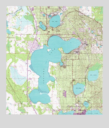
Babson Park, FL USGS Topographic Map
Click on map above to begin viewing in our Map Viewer.

This topographic map contains these locations and features:
Feature Name Type Latitude Longitude GNIS ID View Map
Babson ParkPopulated PlaceN27.8320°W81.5223°278019View Map
Babson Park Census Designated PlaceCensusN27.8342°W81.5281°2402658View Map
Babson Park Post OfficePost OfficeN27.8382°W81.5295°2768120View Map
Bethel ChurchChurchN27.7667°W81.5179°278530View Map
Blue LakeLakeN27.8520°W81.5782°279035View Map
Bobs Landing Mobile Home ParkPopulated PlaceN27.8087°W81.5577°2447684View Map
College Park Mobile Home ParkPopulated PlaceN27.8264°W81.5922°2449602View Map
Crooked LakeLakeN27.8155°W81.5669°293976View Map
Crooked Lake ParkPopulated PlaceN27.8292°W81.5840°281075View Map
Crooked Lake Park Census Designated PlaceCensusN27.8296°W81.5897°2402805View Map
Dale R Fair Babson Park Elementary SchoolSchoolN27.8329°W81.5269°299302View Map
Frostproof Middle Senior High SchoolSchoolN27.7605°W81.5339°299300View Map
Frostproof Mobile Home ParkPopulated PlaceN27.7590°W81.5401°2449103View Map
Goddard SeadromeAirportN27.7556°W81.5137°309447View Map
Highland ParkPopulated PlaceN27.8650°W81.5617°284008View Map
Hillcrest HeightsPopulated PlaceN27.8211°W81.5306°284030View Map
Lake AmoretLakeN27.8638°W81.5685°277839View Map
Lake Clinch AirparkAirportN27.7538°W81.5592°309446View Map
Lake Clinch Manor Mobile Home ParkPopulated PlaceN27.7553°W81.5375°2449104View Map
Lake EasyLakeN27.8579°W81.5620°282050View Map
Lake HelenLakeN27.8291°W81.5029°283866View Map
Lake IdaLakeN27.7623°W81.5212°284459View Map
Lake LeonoreLakeN27.7957°W81.5124°285465View Map
Lake LoralinLakeN27.8420°W81.5093°286096View Map
Lake MoodyLakeN27.7804°W81.5311°287087View Map
Lakeside Gardens Mobile Home ParkPopulated PlaceN27.8223°W81.5927°2449597View Map
Little Crooked LakeLakeN27.7703°W81.5811°2770882View Map
Pleasant View Mobile Home ParkPopulated PlaceN27.7581°W81.5749°2449106View Map
Polk County Fire Department Station 3 Babson ParkBuildingN27.8327°W81.5259°2131483View Map
Polk County Fire Department Station 6 Caloosa LakeBuildingN27.8347°W81.5897°2131468View Map
Polk County Sheriff's Office - Community Policing Unit Babson ParkBuildingN27.8327°W81.5258°2333772View Map
Polk County Sheriff's Office - Community Policing Unit Highland Park ManorBuildingN27.8724°W81.5522°2333776View Map
Reed Mobile Home ParkPopulated PlaceN27.8339°W81.5219°2447683View Map
Ridge LandingAirportN27.7540°W81.5979°2717012View Map
South Lake GordonLakeN27.8458°W81.6222°2764899View Map
Southern Pines Mobile Home ResortPopulated PlaceN27.7510°W81.5676°2449109View Map
Southern Pines Recreational Vehicle ParkPopulated PlaceN27.7510°W81.5674°2449099View Map
Sun Ray Shopping CenterLocaleN27.8336°W81.6248°296056View Map
Sunrise Trailer ParkPopulated PlaceN27.7536°W81.5213°2449110View Map
Town of Hillcrest HeightsCivilN27.8284°W81.5454°2405836View Map
Village of Highland ParkCivilN27.8613°W81.5618°2407476View Map
Webber CollegeSchoolN27.8356°W81.5281°299703View Map
Whidden Mobile Home ParkPopulated PlaceN27.7571°W81.5716°2449111View Map
Whidden Mobile Home Park Number 2Populated PlaceN27.7581°W81.5749°2449102View Map
WXPQ-AM (Babson Park)TowerN27.8367°W81.5304°308621View Map

Note: Coordinates in the location and feature list above are referenced to NAD83 datum.


Copyright (C) 2008-2024 Ryan Niemi / Sunset Dynamics ... All Rights Reserved