TopoQuest Logo
Do you find TopoQuest useful?
Help keep TopoQuest running and adding new maps/features by donating!
Bitcoin:  19c7KJd3qBynnjoSw5npx9KScwjBe4ifkT
Litecoin:  LXs6TkuXGGXo1vDsWCkWVdjQX94eUKd6ui
Home View Maps Find Maps Find Places Resources & Links


Hilda, Missouri Topographic Map

USGS Map Title: Hilda, MO
USGS Map MRC: 36092F8
DRG (GeoTIFF) Download: o36092f8.tif


Neighboring USGS Topographic Map Quads:


  Garrison, MO  
36093G1
 

  Bradleyville, MO  
36092G8
 

  Brownbranch, MO  
36092G7
 

  Forsyth, MO  
36093F1
 

  Hilda, MO  
36092F8
 

  Protem NE, MO  
36092F7
 

  Mincy, MO  
36093E1
 

  Protem SW, MO  
36092E8
 

  Protem, MO  
36092E7


Map MRC Location:

N37°
W93°
N37°
W92°
H8 H7 H6 H5 H4 H3 H2 H1
G8 G7 G6 G5 G4 G3 G2 G1
F8 F7 F6 F5 F4 F3 F2 F1
E8 E7 E6 E5 E4 E3 E2 E1
D8 D7 D6 D5 D4 D3 D2 D1
C8 C7 C6 C5 C4 C3 C2 C1
B8 B7 B6 B5 B4 B3 B2 B1
A8 A7 A6 A5 A4 A3 A2 A1
N36°
W93°
N36°
W92°

Hilda, MO USGS 1:24K Topographic Map Preview:
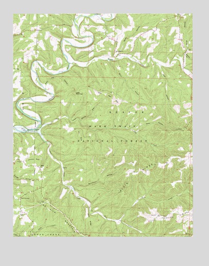
Hilda, MO USGS Topographic Map
Click on map above to begin viewing in our Map Viewer.

This topographic map contains these locations and features:
Feature Name Type Latitude Longitude GNIS ID View Map
Blair CemeteryCemeteryN36.6662°W92.8924°753952View Map
Blair RidgeRidgeN36.6615°W92.9138°748903View Map
Bray CemeteryCemeteryN36.7301°W92.8782°749002View Map
Brink HollowValleyN36.7278°W92.8805°749024View Map
Brown CemeteryCemeteryN36.6373°W92.9957°749038View Map
Brown School (historical)SchoolN36.6381°W92.9957°733636View Map
Brushy CreekStreamN36.7226°W92.9613°749062View Map
Bryant School (historical)SchoolN36.6373°W92.9230°733637View Map
Cane CreekStreamN36.6853°W92.9846°749189View Map
Central Taney County Fire Protection District Station 3BuildingN36.6525°W92.9817°2620630View Map
Chapel of the OzarksChurchN36.6467°W92.9957°749328View Map
Coy BaldSummitN36.6817°W92.9543°749505View Map
Devils DenValleyN36.6903°W92.9541°749640View Map
Edley CemeteryCemeteryN36.6370°W92.9007°749803View Map
Hercules Lookout TowerTowerN36.6848°W92.8827°755206View Map
Hercules-Glades WildernessReserveN36.6894°W92.9263°754402View Map
HildaPopulated PlaceN36.6637°W92.9821°750324View Map
Hilda Lookout TowerTowerN36.6440°W92.9791°755211View Map
Hoot Owl HollowValleyN36.7095°W92.9777°750385View Map
Ironside RidgeRidgeN36.6378°W92.8841°750465View Map
JodyLocaleN36.6701°W92.8855°740415View Map
Johnson BaldSummitN36.6681°W92.9827°750522View Map
Johnson CemeteryCemeteryN36.6670°W92.9943°750525View Map
Johnson School (historical)SchoolN36.6667°W92.9941°733635View Map
Lime Kiln MountainSummitN36.6440°W92.9791°750721View Map
Lone Pilgrim CemeteryCemeteryN36.7189°W92.9954°750830View Map
Long CreekStreamN36.6857°W92.9838°750844View Map
Lower Pilot KnobSummitN36.7056°W92.9577°750884View Map
Mopping BranchStreamN36.7278°W92.8813°751153View Map
Mores BranchStreamN36.7245°W92.9349°751155View Map
New Machion ChurchChurchN36.7289°W92.9285°751301View Map
North HollowValleyN36.7270°W92.9266°751347View Map
North Prong Cane CreekStreamN36.6345°W92.9274°751355View Map
Pees HollowValleyN36.7206°W92.8982°751535View Map
Persimmon HollowValleyN36.6537°W92.9602°751557View Map
Pole HollowValleyN36.6837°W92.9155°751687View Map
Roberts CemeteryCemeteryN36.6464°W92.9535°751912View Map
Sand RidgeRidgeN36.6340°W92.9482°752023View Map
Township of BeaverCivilN36.7115°W92.8787°767453View Map
Upper Pilot KnobSummitN36.7039°W92.9338°752678View Map

Note: Coordinates in the location and feature list above are referenced to NAD83 datum.


Copyright (C) 2008-2024 Ryan Niemi / Sunset Dynamics ... All Rights Reserved