TopoQuest Logo
Do you find TopoQuest useful?
Help keep TopoQuest running and adding new maps/features by donating!
Bitcoin:  19c7KJd3qBynnjoSw5npx9KScwjBe4ifkT
Litecoin:  LXs6TkuXGGXo1vDsWCkWVdjQX94eUKd6ui
Home View Maps Find Maps Find Places Resources & Links


Hetherton, Michigan Topographic Map

USGS Map Title: Hetherton, MI
USGS Map MRC: 45084A3
DRG (GeoTIFF) Download: o45084a3.tif


Neighboring USGS Topographic Map Quads:


  Hardwood Lake, MI  
45084B4
 

  Silver Lake, MI  
45084B3
 

  Lake Geneva, MI  
45084B2
 

  Saunders Creek, MI  
45084A4
 

  Hetherton, MI  
45084A3
 

  Atlanta, MI  
45084A2
 

  Johannesburg, MI  
44084H4
 

  Lewiston, MI  
44084H3
 

  Crooked Lake, MI  
44084H2


Map MRC Location:

N46°
W85°
N46°
W84°
H8 H7 H6 H5 H4 H3 H2 H1
G8 G7 G6 G5 G4 G3 G2 G1
F8 F7 F6 F5 F4 F3 F2 F1
E8 E7 E6 E5 E4 E3 E2 E1
D8 D7 D6 D5 D4 D3 D2 D1
C8 C7 C6 C5 C4 C3 C2 C1
B8 B7 B6 B5 B4 B3 B2 B1
A8 A7 A6 A5 A4 A3 A2 A1
N45°
W85°
N45°
W84°

Hetherton, MI USGS 1:24K Topographic Map Preview:
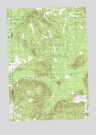
Hetherton, MI USGS Topographic Map
Click on map above to begin viewing in our Map Viewer.

This topographic map contains these locations and features:
Feature Name Type Latitude Longitude GNIS ID View Map
Gingell CemeteryCemeteryN45.0069°W84.3228°626845View Map
Gingell LakeLakeN45.0087°W84.3186°626846View Map
Green SwampSwampN45.0475°W84.2817°627338View Map
HethertonPopulated PlaceN45.0125°W84.3700°1617620View Map
Hetherton Post Office (historical)Post OfficeN45.0125°W84.3700°2438568View Map
Hodge CreekStreamN45.1050°W84.3672°628368View Map
Kissipee Post Office (historical)Post OfficeN45.0469°W84.3667°2438564View Map
Kissipee Station (historical)LocaleN45.0469°W84.3667°2438565View Map
Lake LaBargeLakeN45.1219°W84.2634°1625077View Map
Old Baldy HillSummitN45.0406°W84.2958°633985View Map
Rattlesnake CreekStreamN45.0675°W84.2853°635666View Map
Rattlesnake HillsSummitN45.0645°W84.2653°635667View Map
Shingle Mill BridgeBridgeN45.0706°W84.2845°1623626View Map
Town Corner LakeLakeN45.1142°W84.3649°1614993View Map
Town Corner Lake State Forest CampgroundLocaleN45.1147°W84.3622°2438409View Map
Town Line LakesLakeN45.1092°W84.3081°1615001View Map
Township of ViennaCivilN45.0277°W84.3096°1627202View Map
Tubbs CreekStreamN45.0925°W84.3714°1615143View Map
WAIR-FM (Atlanta)TowerN45.0167°W84.3528°1625343View Map
Walled LakeLakeN45.1222°W84.3624°1615719View Map
West Town Corner LakeLakeN45.1140°W84.2560°1616182View Map

Note: Coordinates in the location and feature list above are referenced to NAD83 datum.


Copyright (C) 2008-2024 Ryan Niemi / Sunset Dynamics ... All Rights Reserved