TopoQuest Logo
Do you find TopoQuest useful?
Help keep TopoQuest running and adding new maps/features by donating!
Bitcoin:  19c7KJd3qBynnjoSw5npx9KScwjBe4ifkT
Litecoin:  LXs6TkuXGGXo1vDsWCkWVdjQX94eUKd6ui
Home View Maps Find Maps Find Places Resources & Links


Heron, Montana Topographic Map

USGS Map Title: Heron, MT
USGS Map MRC: 48115A8
DRG (GeoTIFF) Download: o48115a8.tif


Neighboring USGS Topographic Map Quads:


  Scotchman Peak, ID  
48116B1
 

  Sawtooth Mountain, MT  
48115B8
 

  Ibex Peak, MT  
48115B7
 

  Cabinet, ID  
48116A1
 

  Heron, MT  
48115A8
 

  Smeads Bench, MT  
48115A7
 

  Jordan Creek, ID  
47116H1
 

  Gem Peak, MT  
47115H8
 

  Noxon, MT  
47115H7


Map MRC Location:

N49°
W116°
N49°
W115°
H8 H7 H6 H5 H4 H3 H2 H1
G8 G7 G6 G5 G4 G3 G2 G1
F8 F7 F6 F5 F4 F3 F2 F1
E8 E7 E6 E5 E4 E3 E2 E1
D8 D7 D6 D5 D4 D3 D2 D1
C8 C7 C6 C5 C4 C3 C2 C1
B8 B7 B6 B5 B4 B3 B2 B1
A8 A7 A6 A5 A4 A3 A2 A1
N48°
W116°
N48°
W115°

Heron, MT USGS 1:24K Topographic Map Preview:
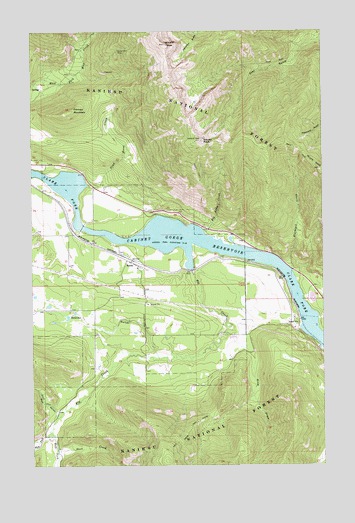
Heron, MT USGS Topographic Map
Click on map above to begin viewing in our Map Viewer.

This topographic map contains these locations and features:
Feature Name Type Latitude Longitude GNIS ID View Map
26N34W03CDBC01 WellWellN48.0397°W115.9677°825742View Map
27N34W28DCDA01 WellWellN48.0677°W115.9821°825966View Map
27N34W35DABA01 WellWellN48.0574°W115.9563°825880View Map
Beaver GulchValleyN48.0305°W115.9463°779621View Map
Big Eddy CreekStreamN48.0669°W115.9266°779802View Map
Billiard TableSummitN48.1213°W115.9429°779913View Map
Blacktail CreekStreamN48.0563°W115.8888°780058View Map
Blue Creek MineMineN48.1202°W115.9691°805125View Map
Broken Hill MineMineN48.1180°W115.9635°805115View Map
Brown Hill MineMineN48.1194°W115.9635°780444View Map
Cabinet Gorge ReservoirReservoirN48.0405°W115.8846°780748View Map
Caseys (historical)LocaleN48.0597°W115.9191°1780968View Map
Dead Horse CreekStreamN48.0808°W115.9766°782135View Map
Deer CreekStreamN48.0046°W115.9899°782245View Map
East Fork Elk CreekStreamN48.0096°W115.9932°782840View Map
Elk CreekStreamN48.0566°W115.9318°783059View Map
Fatman MountainSummitN48.1019°W115.9829°783314View Map
First Baptist Church of HeronChurchN48.0580°W115.9566°1780880View Map
Fredrick and Wind MineMineN48.0963°W115.9177°805116View Map
Gopher Hole MineMineN48.1124°W115.9643°805118View Map
HeronLocaleN48.0588°W115.9571°1780942View Map
HeronPopulated PlaceN48.0588°W115.9571°784801View Map
Heron CemeteryCemeteryN48.0614°W115.9625°1780934View Map
Heron Census Designated PlaceCensusN48.0638°W115.9802°2408378View Map
Heron Community ClinicHospitalN48.0588°W115.9571°1780892View Map
Heron Methodist Church (historical)ChurchN48.0588°W115.9571°1780832View Map
Heron Post OfficePost OfficeN48.0595°W115.9631°1780962View Map
Heron Rural Fire DistrictBuildingN48.0593°W115.9621°2546587View Map
Heron School (historical)SchoolN48.0569°W115.9552°1780833View Map
Knott (historical)LocaleN48.0772°W115.9899°1781024View Map
Laurie Hill LibraryBuildingN48.0588°W115.9571°1780894View Map
Lucky Star MineMineN48.1180°W115.9696°805126View Map
Pew GulchValleyN48.0141°W115.9902°788805View Map
Proctor (historical)LocaleN48.0583°W115.9079°1781001View Map
Red Fir/Amazon MineMineN48.0749°W115.9185°805122View Map
Rice DrawValleyN48.0394°W115.9157°789559View Map
Rice Draw TrailTrailN48.0102°W115.9332°789560View Map
Russelville (historical)LocaleN48.0555°W115.9316°1780995View Map
Star PeakSummitN48.0933°W115.9277°791394View Map
Star Peak Lookout StationLocaleN48.0933°W115.9279°794367View Map
West Fork Elk CreekStreamN48.0096°W115.9932°393093View Map

Note: Coordinates in the location and feature list above are referenced to NAD83 datum.


Copyright (C) 2008-2024 Ryan Niemi / Sunset Dynamics ... All Rights Reserved