TopoQuest Logo
Do you find TopoQuest useful?
Help keep TopoQuest running and adding new maps/features by donating!
Bitcoin:  19c7KJd3qBynnjoSw5npx9KScwjBe4ifkT
Litecoin:  LXs6TkuXGGXo1vDsWCkWVdjQX94eUKd6ui
Home View Maps Find Maps Find Places Resources & Links


Hermon, Maine Topographic Map

USGS Map Title: Hermon, ME
USGS Map MRC: 44068G8
DRG (GeoTIFF) Download: o44068g8.tif


Neighboring USGS Topographic Map Quads:


  West Corinth, ME  
44069H1
 

  Kenduskeag, ME  
44068H8
 

  Pushaw Lake, ME  
44068H7
 

  Carmel, ME  
44069G1
 

  Hermon, ME  
44068G8
 

  Bangor, ME  
44068G7
 

  East Dixmont, ME  
44069F1
 

  Snow Mountain, ME  
44068F8
 

  Hampden, ME  
44068F7


Map MRC Location:

N45°
W69°
N45°
W68°
H8 H7 H6 H5 H4 H3 H2 H1
G8 G7 G6 G5 G4 G3 G2 G1
F8 F7 F6 F5 F4 F3 F2 F1
E8 E7 E6 E5 E4 E3 E2 E1
D8 D7 D6 D5 D4 D3 D2 D1
C8 C7 C6 C5 C4 C3 C2 C1
B8 B7 B6 B5 B4 B3 B2 B1
A8 A7 A6 A5 A4 A3 A2 A1
N44°
W69°
N44°
W68°

Hermon, ME USGS 1:24K Topographic Map Preview:
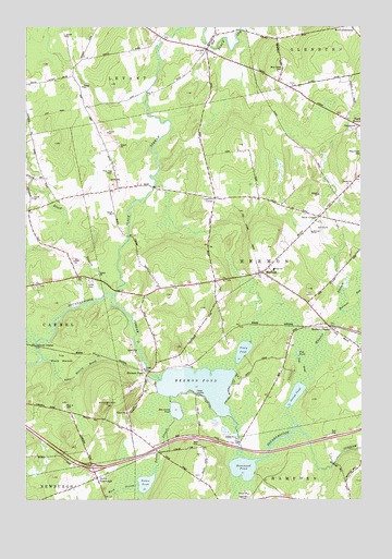
Hermon, ME USGS Topographic Map
Click on map above to begin viewing in our Map Viewer.

This topographic map contains these locations and features:
Feature Name Type Latitude Longitude GNIS ID View Map
Ben Annis PondLakeN44.7736°W68.9438°562035View Map
Birch Grove CemeteryCemeteryN44.8641°W68.9044°562286View Map
Black StreamStreamN44.8056°W68.9667°562513View Map
Dabscook CrossoverLocaleN44.7906°W68.9962°564726View Map
Fowler LandingPopulated PlaceN44.7781°W68.9370°579323View Map
George PondLakeN44.7780°W68.8994°566743View Map
Griffin FieldAirportN44.8680°W68.9772°2717196View Map
Hammond PondLakeN44.7584°W68.9190°567546View Map
HermonPopulated PlaceN44.8101°W68.9134°567953View Map
Hermon Baptist ChurchChurchN44.8090°W68.9092°1913584View Map
Hermon CenterPopulated PlaceN44.7965°W68.8878°567955View Map
Hermon Creative PlaygroundParkN44.8206°W68.8939°1913586View Map
Hermon Elementary SchoolSchoolN44.8203°W68.8936°567958View Map
Hermon Fire DepartmentBuildingN44.8255°W68.8887°2552817View Map
Hermon High SchoolSchoolN44.8097°W68.8992°1913587View Map
Hermon Meadows Golf ClubLocaleN44.8217°W68.8906°1913589View Map
Hermon Middle SchoolSchoolN44.8110°W68.9076°2738067View Map
Hermon PondPopulated PlaceN44.7828°W68.9550°579399View Map
Hermon PondLakeN44.7801°W68.9351°567957View Map
Hermon Pond CemeteryCemeteryN44.7852°W68.9569°2727064View Map
Hermon Volunteer Rescue AmbulanceBuildingN44.8226°W68.8941°2666810View Map
Hinkley HillSummitN44.7752°W68.9694°568105View Map
Interchange 43CrossingN44.7584°W68.9745°1913619View Map
Lakeview CemeteryCemeteryN44.7506°W68.9170°569329View Map
Leathers CornerPopulated PlaceN44.8298°W68.9309°579471View Map
LevantPopulated PlaceN44.8692°W68.9348°569489View Map
Levant Consolidated SchoolSchoolN44.8667°W68.9298°1913661View Map
Levant Heritage LibraryBuildingN44.8698°W68.9347°2738397View Map
Levant Post OfficePost OfficeN44.8668°W68.9296°1913640View Map
Levant Village Baptist ChurchChurchN44.8701°W68.9361°1913662View Map
Miller's FieldAirportN44.7506°W68.9828°2442715View Map
North HermonPopulated PlaceN44.8490°W68.8756°572347View Map
North NewburghPopulated PlaceN44.7556°W68.9731°572367View Map
North Star Christian SchoolSchoolN44.8049°W68.8944°2738194View Map
Patten PondLakeN44.7545°W68.9550°573068View Map
Patten StreamStreamN44.7773°W68.9467°573070View Map
Pine Tree CemeteryCemeteryN44.8367°W68.9672°573405View Map
Pleasant Hill CampgroundLocaleN44.8484°W68.8792°1913826View Map
Pug BrookStreamN44.7828°W68.8948°573860View Map
Pug PondLakeN44.7888°W68.8986°573870View Map
Rug le CemeteryCemeteryN44.7745°W68.9853°574567View Map
Slate Quarry BrookStreamN44.7876°W68.9934°575543View Map
Snow CornerPopulated PlaceN44.8248°W68.8909°575677View Map
Snows Corner CemeteryCemeteryN44.8223°W68.8835°2736938View Map
Suzanne Smith Elementary SchoolSchoolN44.8607°W68.9991°2737949View Map
The Black WoodsWoodsN44.7873°W68.9862°576759View Map
Town of HermonCivilN44.8141°W68.9086°582517View Map
Tracy PondLakeN44.7895°W68.9190°577260View Map
Ward StreamStreamN44.7542°W68.9575°577829View Map
West Branch Souadabscook StreamStreamN44.7565°W68.9198°578092View Map
Wheeler StreamStreamN44.7701°W68.9003°578314View Map
Wheeler Stream Camping AreaLocaleN44.7976°W68.8873°1913986View Map

Note: Coordinates in the location and feature list above are referenced to NAD83 datum.


Copyright (C) 2008-2024 Ryan Niemi / Sunset Dynamics ... All Rights Reserved