TopoQuest Logo
Do you find TopoQuest useful?
Help keep TopoQuest running and adding new maps/features by donating!
Bitcoin:  19c7KJd3qBynnjoSw5npx9KScwjBe4ifkT
Litecoin:  LXs6TkuXGGXo1vDsWCkWVdjQX94eUKd6ui
Home View Maps Find Maps Find Places Resources & Links


Hendricks Peak, New Mexico Topographic Map

USGS Map Title: Hendricks Peak, NM
USGS Map MRC: 32107H8
DRG (GeoTIFF) Download: o32107h8.tif


Neighboring USGS Topographic Map Quads:


  North Star Mesa, NM  
33108A1
 

  Hay Mesa, NM  
33107A8
 

  Victorio Park, NM  
33107A7
 

  Allie Canyon, NM  
32108H1
 

  Hendricks Peak, NM  
32107H8
 

  Hillsboro Peak, NM  
32107H7
 

  Santa Rita Mine, NM  
32108G1
 

  San Lorenzo, NM  
32107G8
 

  Maverick Mountain, NM  
32107G7


Map MRC Location:

N33°
W108°
N33°
W107°
H8 H7 H6 H5 H4 H3 H2 H1
G8 G7 G6 G5 G4 G3 G2 G1
F8 F7 F6 F5 F4 F3 F2 F1
E8 E7 E6 E5 E4 E3 E2 E1
D8 D7 D6 D5 D4 D3 D2 D1
C8 C7 C6 C5 C4 C3 C2 C1
B8 B7 B6 B5 B4 B3 B2 B1
A8 A7 A6 A5 A4 A3 A2 A1
N32°
W108°
N32°
W107°

Hendricks Peak, NM USGS 1:24K Topographic Map Preview:
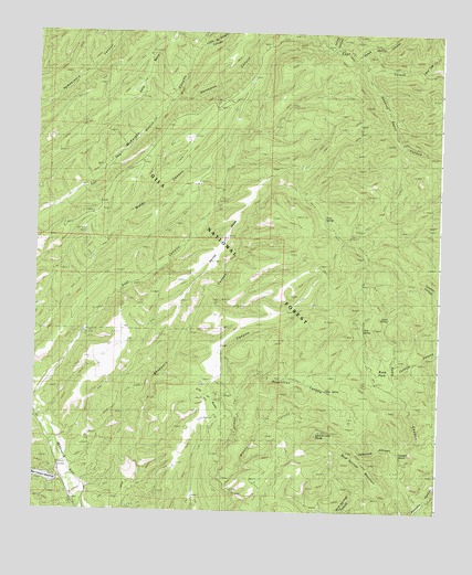
Hendricks Peak, NM USGS Topographic Map
Click on map above to begin viewing in our Map Viewer.

This topographic map contains these locations and features:
Feature Name Type Latitude Longitude GNIS ID View Map
Aspen SpringSpringN32.9724°W107.8879°898908View Map
Bear CanyonValleyN32.8829°W107.9906°903632View Map
Bear Canyon ReservoirReservoirN32.8834°W107.9964°898902View Map
Bear Canyon Reservoir DamDamN32.8829°W107.9923°924157View Map
Bear Trap CanyonValleyN32.9909°W107.8817°903686View Map
Brushy CanyonValleyN32.8823°W107.9409°904108View Map
Cabin SpringSpringN32.9070°W107.9109°2038390View Map
City of RocksLocaleN32.9048°W107.9464°2038405View Map
Cureton CanyonValleyN32.9176°W107.8759°905560View Map
Dale TankReservoirN32.9863°W107.9795°898903View Map
Davis TankReservoirN32.9827°W107.9871°898896View Map
Dutchman CanyonValleyN32.9826°W107.9573°905917View Map
Dutchman TankReservoirN32.9952°W107.9420°898905View Map
East CanyonValleyN32.9054°W107.9989°905955View Map
East TankReservoirN32.9702°W107.9654°2038451View Map
Gatlin TankReservoirN32.9410°W107.9177°898886View Map
Girty SpringSpringN32.9231°W107.8995°2038481View Map
Hendricks PeakSummitN32.8951°W107.9136°906928View Map
Horse TankReservoirN32.8756°W107.9114°2038506View Map
JT TankReservoirN32.9688°W107.9915°898898View Map
Juan Mesa TankReservoirN32.9602°W107.9505°898916View Map
Juan Mesa Tank Number TwoReservoirN32.9346°W107.9818°898900View Map
Juniper TankReservoirN32.9825°W107.9691°898904View Map
Kelly Mesa TankReservoirN32.9984°W107.9631°2038531View Map
Kelly Ridge TankReservoirN32.9739°W107.9993°898897View Map
Lake Superior TankReservoirN32.9269°W107.9272°898920View Map
Little McKnight CanyonValleyN32.9965°W107.9495°908034View Map
Lower WellWellN32.9340°W107.9695°898887View Map
McKnight WellWellN32.9650°W107.9792°898899View Map
Middle TankReservoirN32.9780°W107.9118°898907View Map
Mimbres DivisionCivilN32.9241°W107.9728°1937558View Map
Mud Springs MountainSummitN32.8906°W107.9042°908957View Map
Nicholi TankReservoirN32.9353°W107.9510°898888View Map
North Water TankReservoirN32.9866°W107.9344°898906View Map
Ott TankReservoirN32.9406°W107.9828°933103View Map
Pale TankReservoirN32.9465°W107.9900°2038605View Map
Pasture SpringSpringN32.9084°W107.8984°898911View Map
Pence TankReservoirN32.9820°W107.9433°898912View Map
Pit TankReservoirN32.9573°W107.9564°2038624View Map
Pit TankReservoirN32.9263°W107.9447°898889View Map
Pothole TankReservoirN32.9672°W107.9661°898915View Map
Quaking Asp CanyonValleyN32.9901°W107.8986°909912View Map
Rabb CanyonValleyN32.8773°W107.8817°909946View Map
Rabb ParkFlatN32.9111°W107.8931°909947View Map
Rabb SpringSpringN32.9259°W107.8914°2038640View Map
Race SpringSpringN32.9180°W107.8884°898910View Map
Rays TankReservoirN32.9716°W107.9532°898914View Map
Ridge Tank Number TwoReservoirN32.9520°W107.9109°898918View Map
Rosencran CanyonValleyN32.9054°W107.9367°910432View Map
Rosencrans TankReservoirN32.9159°W107.9370°2038656View Map
Skillet MesaRidgeN32.9476°W107.9411°911117View Map
Spring CanyonValleyN32.9959°W107.9098°911320View Map
Stitzel TankReservoirN32.9293°W107.9141°898909View Map
Trail Canyon TankReservoirN32.9187°W107.9195°2038720View Map
Trap SpringSpringN32.9520°W107.9109°898919View Map
Trap TankReservoirN32.9228°W107.9721°898901View Map
Turkey DamDamN32.9576°W107.8903°936724View Map
Upper WellWellN32.9590°W107.9429°898917View Map
Valentine CanyonValleyN32.8881°W107.8873°912025View Map
Valentine SpringSpringN32.8906°W107.8878°2038745View Map
Water Canyon TankReservoirN32.9799°W107.9395°898913View Map
Yates Spring CanyonValleyN32.9934°W107.9028°912519View Map

Note: Coordinates in the location and feature list above are referenced to NAD83 datum.


Copyright (C) 2008-2024 Ryan Niemi / Sunset Dynamics ... All Rights Reserved