TopoQuest Logo
Do you find TopoQuest useful?
Help keep TopoQuest running and adding new maps/features by donating!
Bitcoin:  19c7KJd3qBynnjoSw5npx9KScwjBe4ifkT
Litecoin:  LXs6TkuXGGXo1vDsWCkWVdjQX94eUKd6ui
Home View Maps Find Maps Find Places Resources & Links


Hellion Rapids, Oregon Topographic Map

USGS Map Title: Hellion Rapids, OR
USGS Map MRC: 44123D7
DRG (GeoTIFF) Download: o44123d7.tif


Neighboring USGS Topographic Map Quads:


  Toledo South, OR  
44123E8
 

  Elk City, OR  
44123E7
 

  Harlan, OR  
44123E6
 

  Tidewater, OR  
44123D8
 

  Hellion Rapids, OR  
44123D7
 

  Grass Mountain, OR  
44123D6
 

  Cannibal Mountain, OR  
44123C8
 

  Five Rivers, OR  
44123C7
 

  Digger Mountain, OR  
44123C6


Map MRC Location:

N45°
W124°
N45°
W123°
H8 H7 H6 H5 H4 H3 H2 H1
G8 G7 G6 G5 G4 G3 G2 G1
F8 F7 F6 F5 F4 F3 F2 F1
E8 E7 E6 E5 E4 E3 E2 E1
D8 D7 D6 D5 D4 D3 D2 D1
C8 C7 C6 C5 C4 C3 C2 C1
B8 B7 B6 B5 B4 B3 B2 B1
A8 A7 A6 A5 A4 A3 A2 A1
N44°
W124°
N44°
W123°

Hellion Rapids, OR USGS 1:24K Topographic Map Preview:
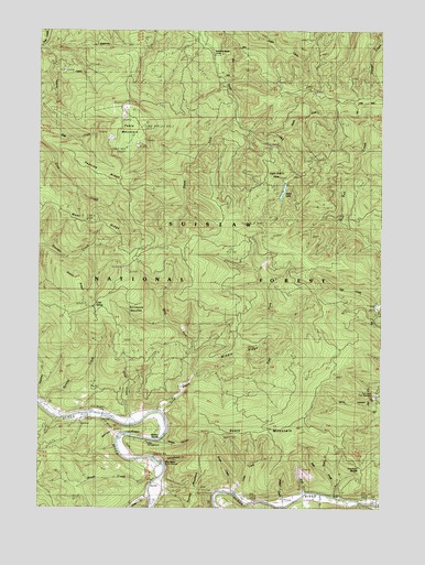
Hellion Rapids, OR USGS Topographic Map
Click on map above to begin viewing in our Map Viewer.

This topographic map contains these locations and features:
Feature Name Type Latitude Longitude GNIS ID View Map
Ayers LakeLakeN44.4570°W123.7874°1134487View Map
Barclay CreekStreamN44.4004°W123.8721°1137508View Map
Barkleys Boat LaunchLocaleN44.3988°W123.8638°2668271View Map
Bear CreekStreamN44.3779°W123.7676°1137658View Map
Bohannon RanchLocaleN44.4937°W123.8129°1138384View Map
Brush CreekStreamN44.3815°W123.8334°1138712View Map
Butler CreekStreamN44.3787°W123.8054°1139047View Map
Carns CanyonValleyN44.4023°W123.7537°1139385View Map
Cedar CreekStreamN44.3787°W123.8037°1139503View Map
Cold SpringSpringN44.4276°W123.8556°1139938View Map
Cow CreekStreamN44.3765°W123.7640°1140282View Map
Death RidgeRidgeN44.4312°W123.8604°1140770View Map
East Fork Scott CreekStreamN44.4093°W123.8184°1141601View Map
Grass CreekStreamN44.3810°W123.8748°1142953View Map
Hellion CanyonValleyN44.3921°W123.8298°1143462View Map
Hellion RapidsRapidsN44.3923°W123.8334°1143463View Map
Hellion Rapids Boat LaunchLocaleN44.3935°W123.8300°2668598View Map
Hellion RidgeRidgeN44.3948°W123.8498°1153571View Map
Klickitat ShelterLocaleN44.4423°W123.8387°1144668View Map
Klickitat SpringSpringN44.4421°W123.8401°1153561View Map
Meander Along CreekStreamN44.3990°W123.8707°1153575View Map
Middle RidgeRidgeN44.4176°W123.8004°1146179View Map
Mike Bauer Recreation SiteLocaleN44.3860°W123.8293°1146195View Map
Mike Bauer Wayside Boat RampLocaleN44.3871°W123.8320°2668590View Map
Minotti CreekStreamN44.3776°W123.7726°1146344View Map
North Fork Drift CreekStreamN44.4726°W123.7909°1134490View Map
Nye CreekStreamN44.4282°W123.7521°1147093View Map
Oregon Hatchery Research CenterLocaleN44.4043°W123.7532°1134491View Map
Peavine RidgeRidgeN44.4643°W123.8584°1147545View Map
Phillips CreekStreamN44.3754°W123.7862°1153563View Map
Riveredge Boat LaunchLocaleN44.3777°W123.8028°2668520View Map
Riveredge Recreation SiteLocaleN44.3768°W123.8009°1155940View Map
Rock CreekStreamN44.3851°W123.7729°1153574View Map
Schoolhouse CreekStreamN44.3860°W123.8296°1149137View Map
Scott CreekStreamN44.3996°W123.8318°1149169View Map
Scott MountainSummitN44.3940°W123.8012°1149171View Map
Slide Campground (historical)LocaleN44.3929°W123.8387°1153572View Map
Slide CreekStreamN44.3965°W123.8429°1149701View Map
Slide CreekStreamN44.4735°W123.8746°1149703View Map
Smallwood CreekStreamN44.3804°W123.8318°1153573View Map
South Fork Drift CreekStreamN44.4762°W123.8034°1134489View Map
Stoney MountainSummitN44.3773°W123.8179°1150450View Map
Surveyors BenchesBenchN44.4262°W123.8393°1150707View Map
Table MountainSummitN44.4690°W123.8437°1150814View Map
Table Mountain CreekStreamN44.4715°W123.8637°1153562View Map
Tenmile ShelterLocaleN44.4635°W123.8259°1150978View Map
Trenholm SaddleGapN44.3876°W123.7523°1151412View Map
Upper Drift Creek SlideSlopeN44.4623°W123.7901°1134488View Map
West Fork Scott CreekStreamN44.4093°W123.8182°1152111View Map
West RidgeRidgeN44.4548°W123.8718°1152141View Map
Wolf CreekStreamN44.3785°W123.7779°1152575View Map

Note: Coordinates in the location and feature list above are referenced to NAD83 datum.


Copyright (C) 2008-2024 Ryan Niemi / Sunset Dynamics ... All Rights Reserved